History
of The Cherry Tree and Feniscliffe Areas
By
Mike Sumner
This area lies to the north and north-east of the Witton
Township with the River Darwen forming the boundary from Feniscliffe Bridge
(see photo below), just beyond the point where the River Blakewater enters the
River Darwen on its journey from Blackburn. To the south and east lies Mill
Hill and Livesey districts and, beyond the area to the west, lies Feniscowles
beyond Feniscowles Viaduct (see photo below).
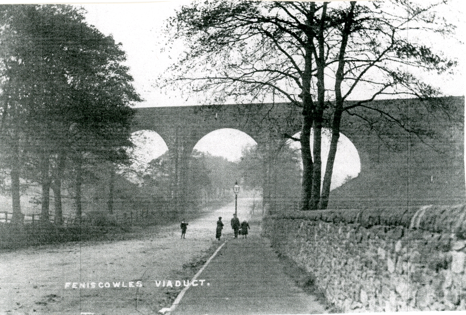
A
1900’s Picture of Feniscowles Railway Viaduct Viewed From Cherry Tree
to the
Feniscowles Area with Local Pedestrians.
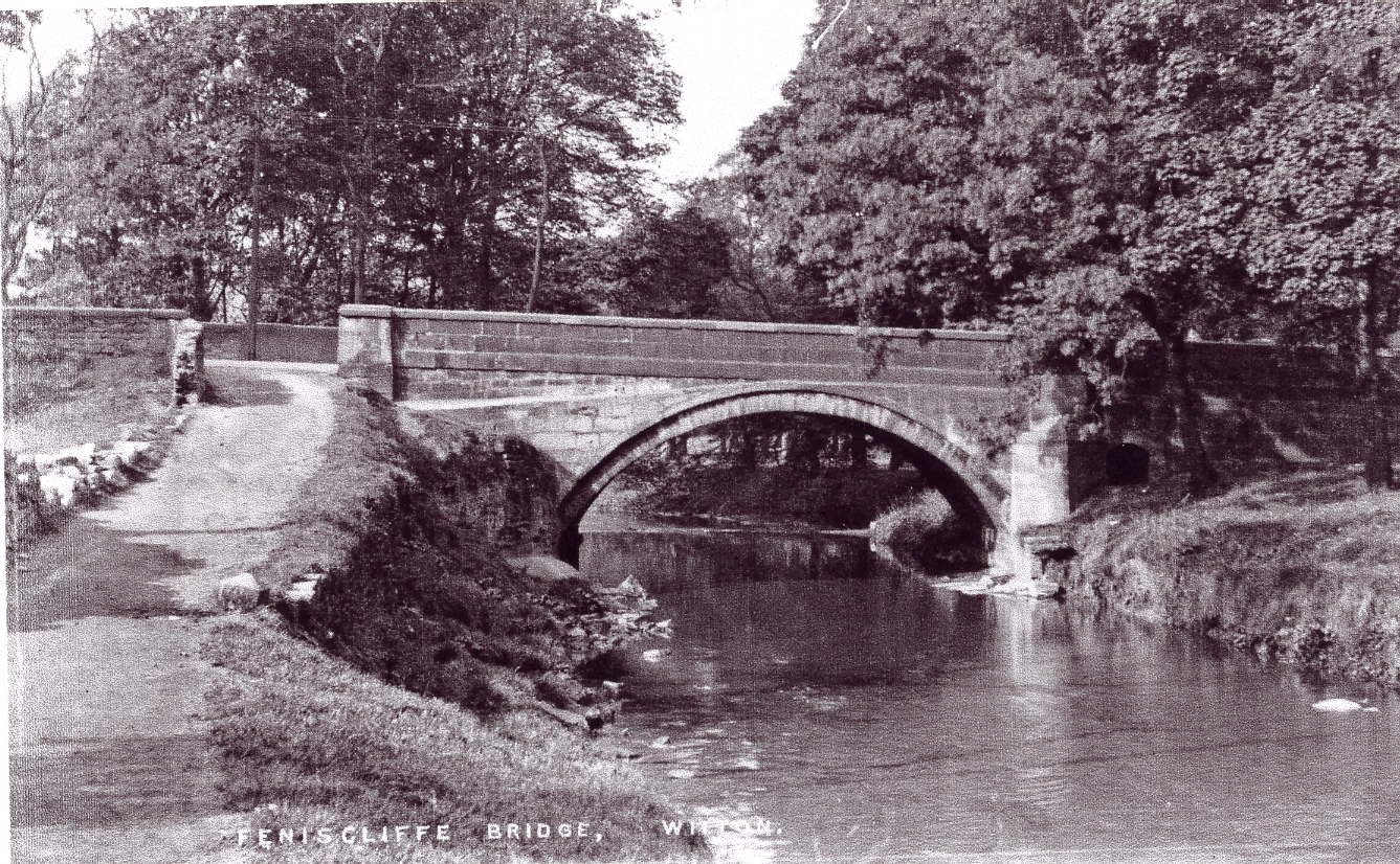
The River Darwen Passing Under Feniscliffe Bridge on its Journey From Mill Hill to the
Witton Area with Preston Old Road Passing Over it.
Cherry
Tree and Feniscliffe Areas in 1818
The earliest map of the area shown below is by Greenwoods
of London, dated 1818, which shows the area is beyond the Blackburn boundary. The
only named building was Livesey Hall with few other buildings mainly situated close
to the old Preston to Blackburn Turnpike road (Preston Old Road), other than
two isolated farms. Cherry Tree, by 1818, had not developed as a specific area although
the name was used in 1800, with the building of Cherry Tree House. Feniscliffe
can be traced back further, named Faniscliffe in 1522, when its land was
exchanged by John the son and heir of John Garstang of Stanworth for tenements
in Walton-le-Dale. It was then conveyed to Robert Harwood of Livesey in 1564
(James 1st era) by James Garstang, a gentleman. In 1666, the hearth
tax paid in the area was by Ralph Livesey and Richard Whitehalgh. By 1788, the
largest contributors for the land tax in the area were Edward Haworth and Mrs.
Wilson.
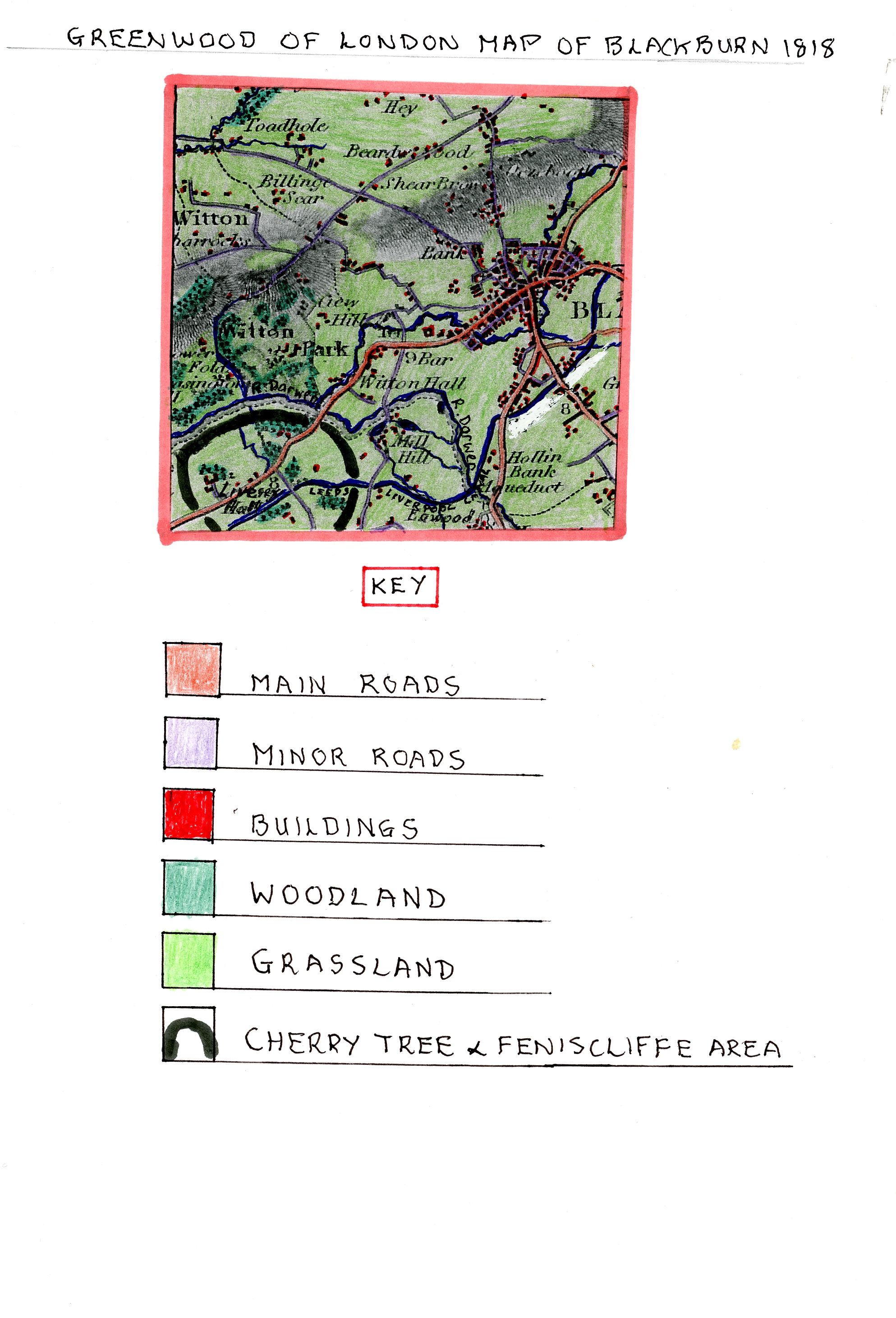
Greenwood
of London Map of Blackburn 1818.
It is clear that in the early days of the Cherry Tree and
Feniscliffe that these areas were dominated by the Livesey Family whose home
was Livesey Old Hall. The Livesey family controlled the Livesey Township or
Manor which covered a wide area to the south and west of Blackburn. The word
Livesey is derived from the old English words “Leofs Eye” which means the
island of Leof who was possibly an original Saxon landowner. This indicates
that in very early times this was a slightly elevated area surrounded by
marshland around the River Darwen. The family history before the 13th
Century is obscure with the first member of the family being Galfred de
Levesaye who gave his son Hugh some crofts in Tocholes in 1220. The family can
be traced without a break for 600 years to the 19th Century. In 1393,
it is recorded that John de Livesey, son and heir of his father John, was then
under age and in the custody of the Lord Duke to hold the manor of Livesey from
the Duke of Lancaster by Knights service. He was still shown as a junior in
1408, 1415 and 1422, but later, his son called Geoffrey (Galfred) appeared as a
witness to a deed of Henry VI in 1442.
James Livesey, a governor of Blackburn Grammar School,
who died in 1619, built the earliest parts of Livesey Old Hall on a low
sheltered site by the north-west border of the Livesey Township above the River
Darwen Valley close to the Preston to Blackburn Turnpike between Cherry Tree
and Feniscowles (near Feniscowles Railway Viaduct). It was built to a plan of
an E as were many houses at this time as a tribute to Queen Elizabeth and
situated with a picturesque background of trees.
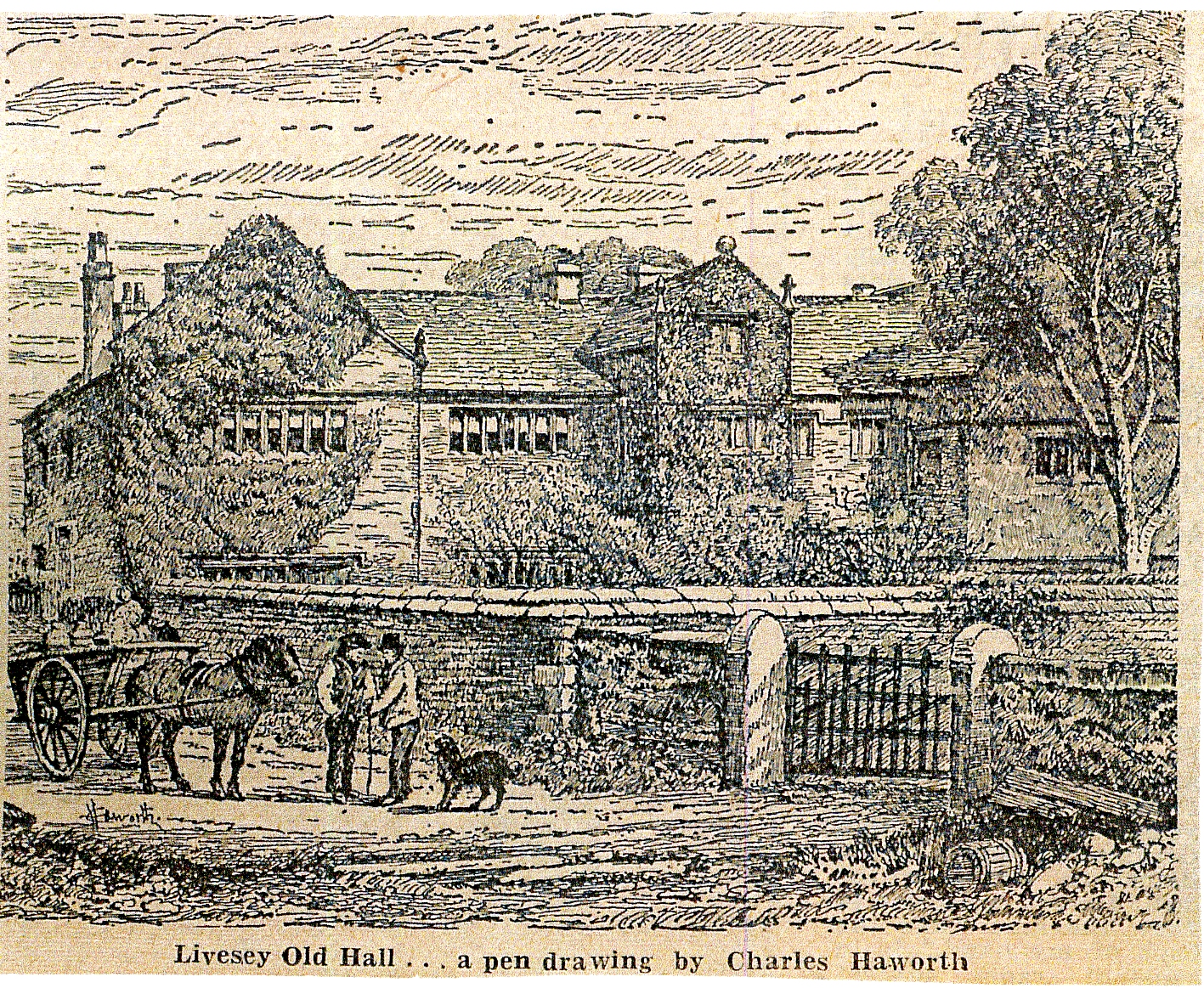
A
Sketch of Livesey Old Hall by Charles Haworth
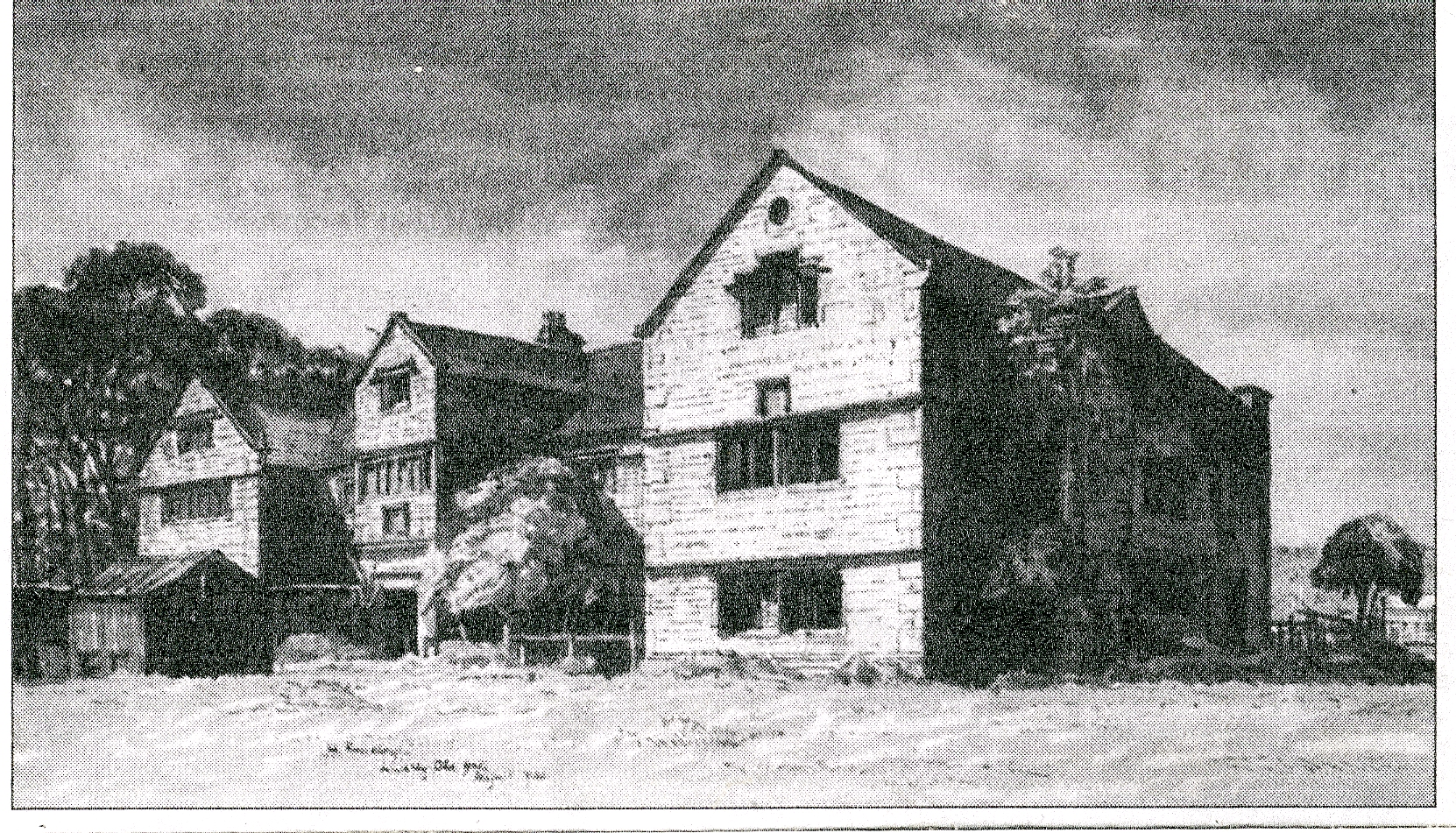
A
Photo of Livesey Old Hall Showing the “E” Shape
of This Fine Jacobean Manor House
The hall was a long building with three wings and, over
the central porch, was an engraved stone with the Livesey coat of arms and, on
another stone, the motto ‘Deo Soli Gloroa’ with the initials of JLAL in respect
of James Livesey and his wife Alice dated 1608, although the hall was probably first
built in the late 1500’s. On the north-east wing was a lettered stone with the
initials RLAL dated 1666 for Ralph Livesey who added the wing and his wife
Anne. On the opposite wing the most modern structure were the initials RA
&P for Ralph and Anne Livesey together with their son Porter dated 1689.
The hall was a two story stone building with attics in the gable and a large
central hall, original mullioned windows with moulded dripstones. Originally,
the hall had formal gardens and a detached subterranean structure with thick
walls, possibly an ice house or used to store arms. Inside the hall had a fine
Jacobean staircase built of oak and oak panelled rooms with a door opposite the
entrance porch clearly showing a medieval arrangement with a screen and
passage. Ralph had a daughter who died unmarried so the ancient manor passed to
the Bell family, and eventually, to Henry and William Feilden, in 1805, of
Witton and Feniscowles Halls. The
Feilden’s divided the building with an unsightly wall, with the west side
occupied by William Feilden and the east side eventually allowed to become a
ruin after sections were tenanted to farmers. Eventually, due to its condition,
it was demolished in the late 1960’s in order to make way for a modern estate
of semi-detached houses (Woodlands/The Crescent).
The 1818 map also shows the area had been crossed by the
newly built Leeds and Liverpool Canal on its way to Blackburn and would soon
become an important transport link for the developing cotton textile
revolution. Witton Hall sited close to Feniscliffe was built by William Fielden
in Witton Park. Witton Old Hall was built by a branch of the Astley family of
Stakes Hall (in nearby Mill Hill) who can be traced back to the early 1500’s
and who also owned land in Ewood. George Astley lived in Witton Old Hall after
it was built. Another ancient building shown on the map, close to the Preston
to Blackburn turnpike, at the top of Feniscliffe brow, is Feniscliffe Farm with
woodland on the river side. This would have been a pastoral farm with both
cattle and sheep sited above the Blackburn boundary but also close to the Witton
Township and south-west Blackburn where it could sell milk and farm produce. It
was an old stone building with outhouses and possibly a farm cottage as two
buildings are shown on the map. The farm was still present in 1933 (see bill
head below) close to, where later, an entrance road was developed (Tower Road)
on a former track/pathway to the newly developed Pleasington Playing Fields.
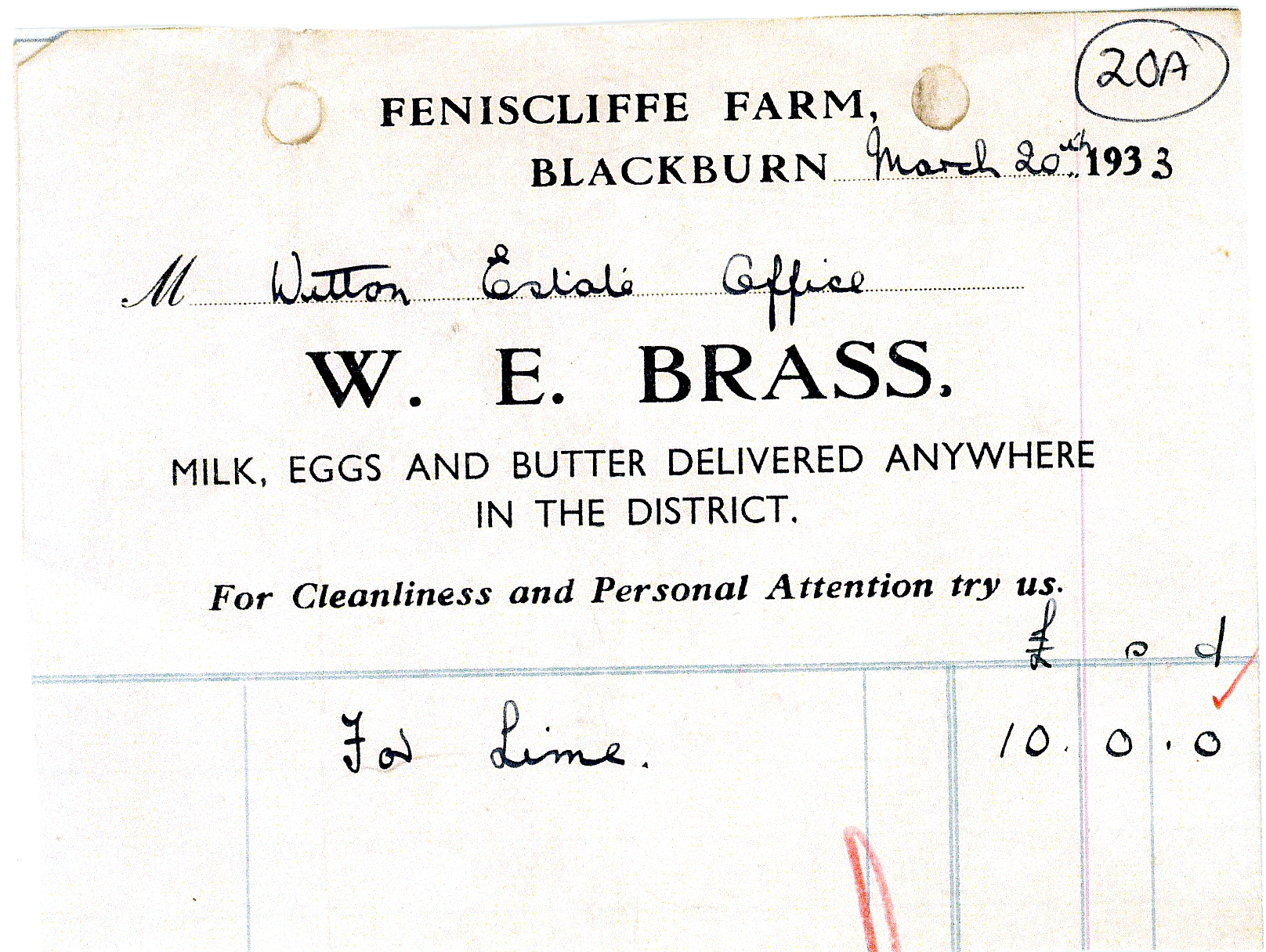
Bill
Head for Goods Sold to Witton Hall From Feniscliffe
Farm by its Owner W.E. Brass
The Boardman family of Livesey, Witton and Feniscliffe
have a close association with the origins of Cherry Tree. Robert Boardman of
Livesey was a yeoman and his brother Edward lived in Witton in the early
1700’s. Robert married Jane and had sons William and Edward. Later, William
Boardman had a son Robert who died in 1759 and, another son, William, who died
in 1761. William’s wife survived him and was shown as a widow living in
Feniscliffe with her son Robert shown as a gentleman living at Cherry Tree
House. It is presumed, therefore, that he built the house naming it after a
cherry tree that had grown on the site. This is the earliest use of the name
Cherry Tree which would soon develop into a specific area of its own. The house
had gardens, a shippon, a gig house and two parcels of land indicating some
kind of farming. Robert’s wife, Elizabeth, died in 1822 and she had sons called
James and Robert with Robert shown living at Cherry Tree House where he died in
1842. Cherry Tree House was said to be pleasantly situated and well adapted for
a respectable family one and a half miles from Blackburn Centre on the old
Preston Turnpike (see 1848 O.S.Map). The house is the 3rd building
on the right from Livesey Hall on the 1818 map. There must have been more than
one cherry tree growing in this specific area as a cherry tree once grew on the
railway station platform at Cherry Tree in the latter 1840’s which was later
removed for a Royal Visit in 1888 (see later).
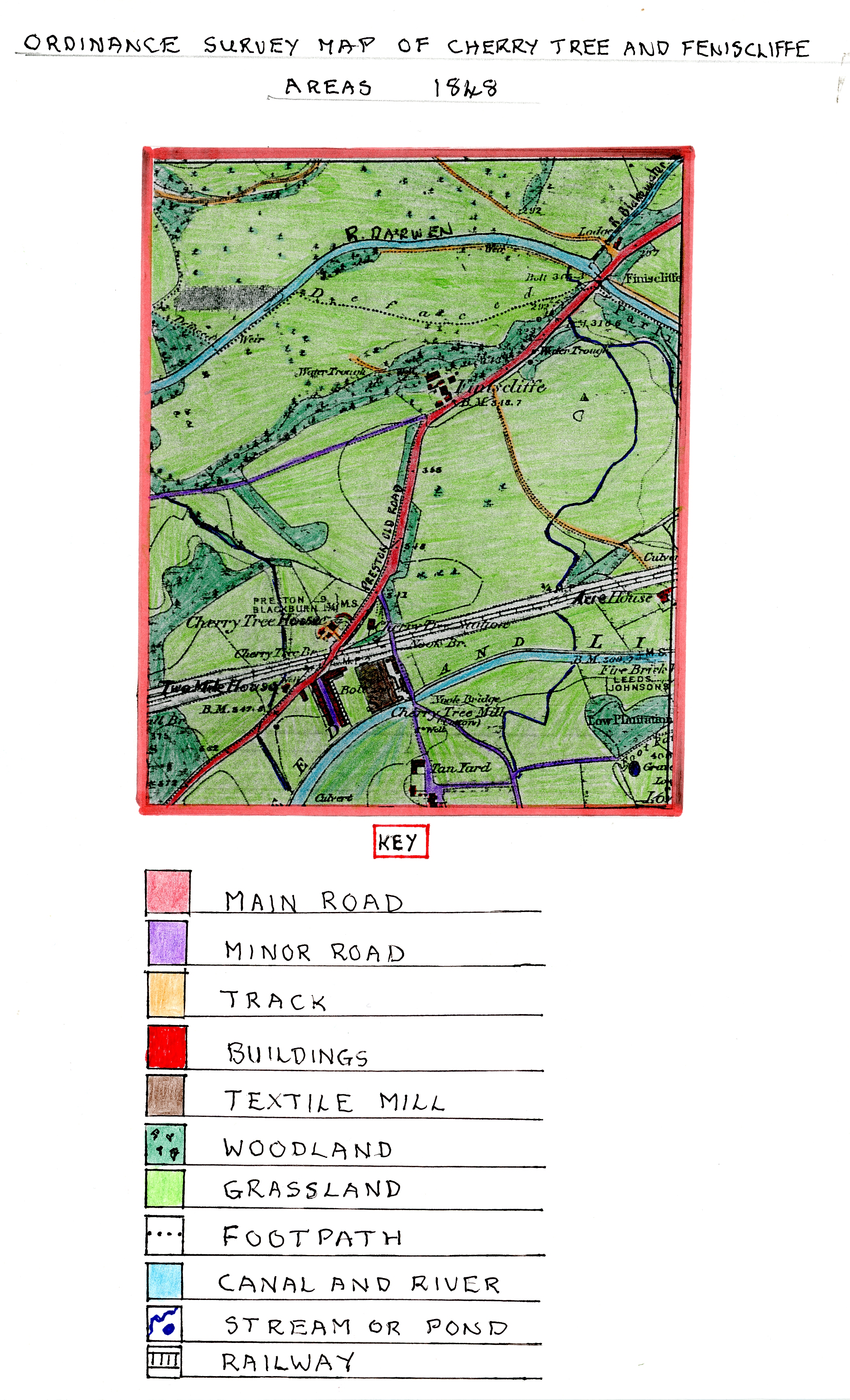
Location
Map Showing Historic Houses of Interest From
the Text on the 1848 Ordnance Survey Map
It was also known that coal mining took place at a
Livesey colliery in the 19th century which was situated beside
Preston Old Road in the Cherry Tree area and continued to the end of the
1800’s. This presumably, from the name, mayhave been owned by the Livesey
family and would have become more important when the Textile Industry developed
in the 1850’s as steam power became more widely used.
This map clearly shows that Finiscliffe (Feniscliffe)
Farm had grown since 1818 with a number of buildings and probably more farm
workers cottages on its flat site above the River Darwen valley. By now, just
outside this area in Witton can be seen a lodge and a long driveway to Witton House
owned by William Feilden in its huge grounds called Witton Park. The 1848
Slater’s Directory lists a Robert Kemp of Feniscliffe operating as a gardener
and seedsman in the area. Below Feniscliffe Farm, on the side of Preston old
Road, is a water trough that was well used by horses pulling carts up
Feniscliffe Brow when they stopped to use it.
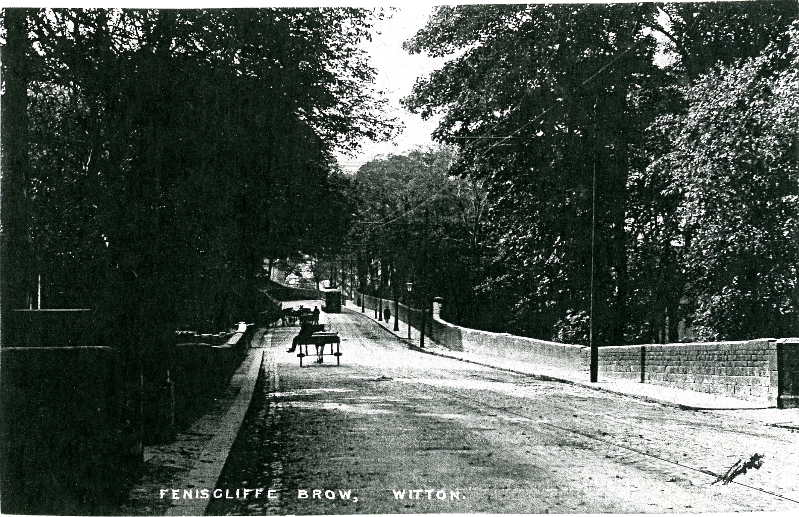
Early
1900’s Photograph of Feniscliffe Brow Looking up Preston Old Road
to the Feniscliffe Farm Area Where the Horses Have
Stopped to use the Water Trough.
Another new addition to the area is a minor road or track
running from Preston Old Road by Feniscliffe Farm down towards Pleasington with
the upper part later being called Tower Road. A further track had developed
from Feniscliffe across fields to Acre House in Livesey which was probably a
farm operating at this time. There were now minor roads leading from Preston
Old Road at Cherry Tree to serve the new Cherry Tree Cotton Mill and a tannery
close by with extensions into the Livesey area. By now, a major west to east
communication link had been built across the area passing through the centre of
Cherry Tree, namely the Preston to Blackburn Railway Line which was the first
railway to serve the Blackburn area and had a station at Cherry Tree. It
received Parliamentary approval in June 1844 and opened on the 1st
June 1846; operated by the East Lancashire Railway Company, then taken over by
Blackburn Railway Company, which however, did not have its own locomotives or
rolling stock and was worked by the Lancashire and Yorkshire railway, who, by
1859, owned the railway network serving Blackburn. By the 1870’s/80’s, the
railway was well known to be inefficient and in poor condition but when the
management changed, in the late 1890’s, was well run and cost effective. It now
carried an exceptionally high level of heavy freight traffic and had a dense
network of local and short distance passenger trains operating, for example a
branch line opened in 1869 from Cherry Tree to Chorley which used a railway
viaduct over Preston Old Road at its boundary with Feniscowles (see photo
below).
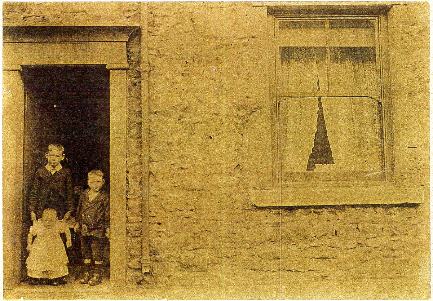
An Early Photograph of 25, Granville Street a Typical Stone Built
Terraced Cottage of This Period With Children in the Doorway.
Cherry Tree Railway Station can be seen on the 1848 map
together with railway sidings and an engine house. The 1849 Railway guide Map
shown below shows the route the railway took through the Blackburn area including
Cherry Tree.
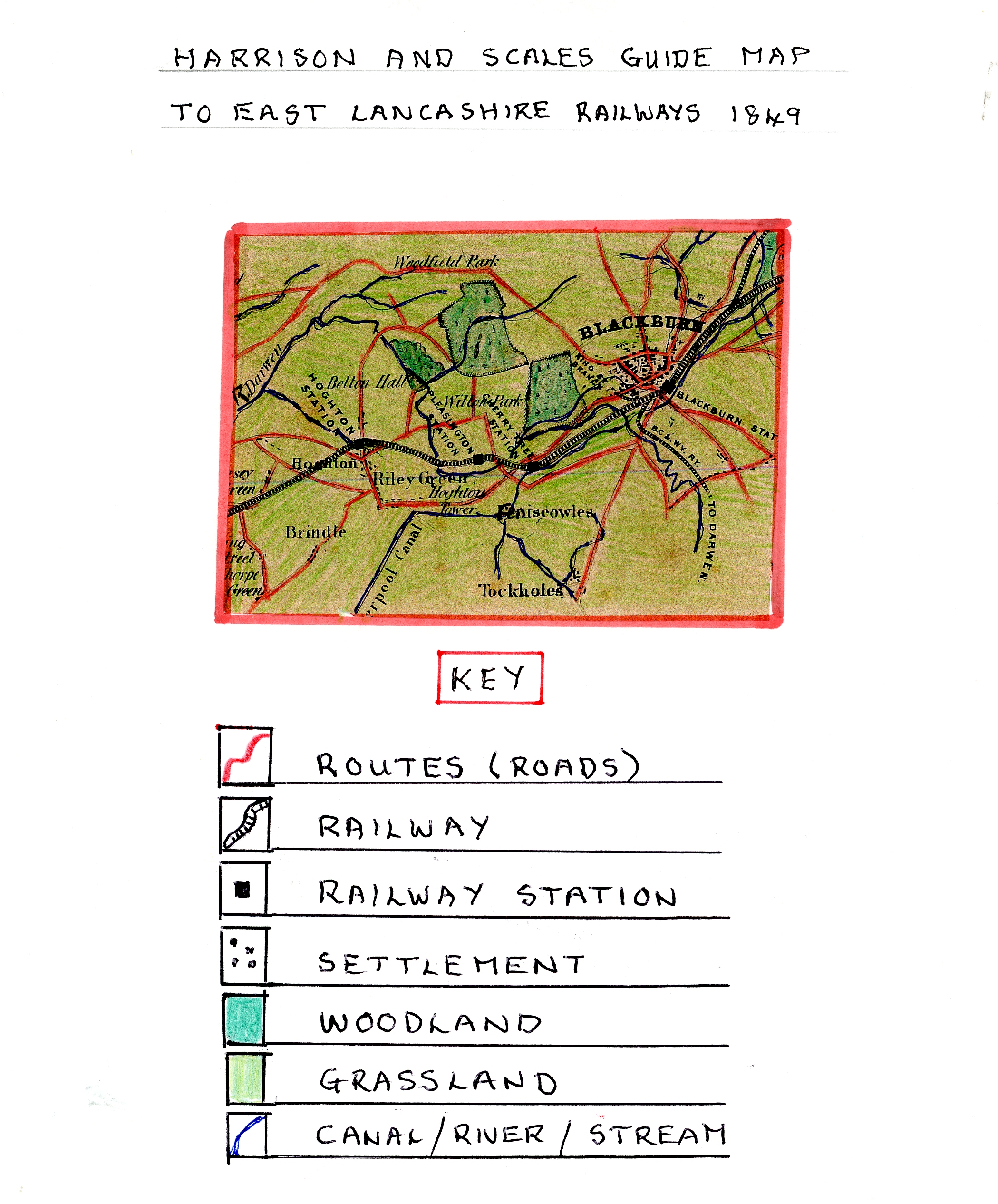
Harrison
and Scales Railway Guide Map of the Blackburn Area in 1849
The close proximity of the railway and the Leeds
Liverpool Canal led to the development of Cherry Tree as a settlement. The
railway and canal facilitated early industrial development, especially Textiles,
with power and transport requirements and dictated where industry sited its
mills and allied works. Canal transport provide a water supply for steam
powered machinery and a cheap transportation system for bulky goods, for
example, coal used for steam power, raw
cotton and chemicals required for textile processes and then the movement of
finished goods. Cherry Tree became a self-contained textile community,
relatively remote from Blackburn, and although the railway opened in 1846,
neither of the Mills in Cherry Tree used railway connections preferring the
canal till well into the 20th century. Cherry Tree became a company
village from 1869 when both its textile mills were first owned by the Cherry
Tree Mill Company, and then, by John Dugdale and Sons.
Cherry Tree Mill
As the map shows this was a large cotton textile mill
squeezed between the railway and canal which started as a cotton weaving shed
in 1845/46 owned by William Poulding and Brothers who by 1850 had added a
spinning block. This meant it now had 13,300 mule spinning spindles and 285
weaving looms powered by a 70hp. steam beam engine and employed 500 to 600
people many being young children. In 1858, John Dugdale and Sons run by John,
Edward and Joseph Dugdale purchased the mill and built further extensions which,
by 1878, meant it had increased plant to 29,444 spinning spindles and 415 weaving
looms. The weaving shed was a single story building nearer the railway
embankment with the spinning section in a larger building with more floors and
a stone built warehouse with a hipped roof on the canal side. The 1848 map
shows terraced mill housing built to the west of the mill on both sides of
Granville Street by the original owners to house their workers many of whom
would have migrated from the surrounding rural areas and farming employment to
work in the new cotton mill.
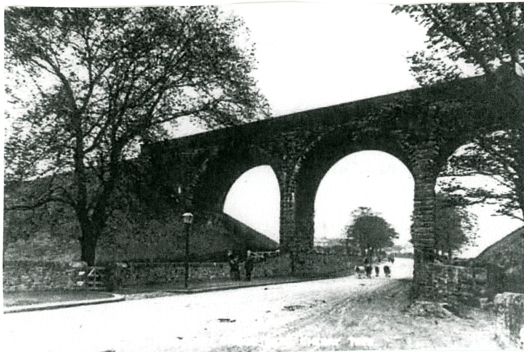
Photograph of the Railway Viaduct at Cherry Tree
Taken in the Early 1900’s With Little or no Road Transport to
be Seen Only People and Animals.
Bank Mill
This large cotton textile mill was built in Cherry Tree
to the west of Cherry Tree Mill between 1861 and 1865 on the tow path side of the
Leeds Liverpool canal by Thomas Alexander Mercer who was a Tanner and farmer of
the Cherry Tree area. His Tanning Yard and house (Nook House – see 1893 map) is
shown on the edge of Cherry Tree and Livesey. The Mercers were members of the
Abbottt family who at one time traded as Cherry Tree Mill Company. The building
of this mill was spread over four years as it was interrupted by the Cotton
Famine when supplies of raw cotton especially from the USA were badly hit which
caused widespread unemployment in the textile industry. The mill had a compound
horizontal steam beam engine built by W.& J. Yates which was installed in
1863/4 to power its machinery. By 1869, Cherry Tree Mill Company along with
A.E. Coddington (another textile magnate) had become major shareholders in the
mill after a fire in 1861 and, by 1877, John Dugdale and Sons had taken over
the running of the mill along with Cherry Tree Mill having enlarged the
spinning section at Bank Mill. The mill had 23,340 mule spindles in 1880 with
ring frames introduced later in the 1920’s together with 29,600 ring spindles
and a new rope drive horizontal engine which was introduced and probably built
by the local firm Yates and Thomas. The Dugdales ceased business at the mill in
1959. The mill itself was a four storey spinning mill with a yarn cellar under
part of it. To the east of the mill was an extension containing a cardroom
built of random stone and an integral blow house and cotton store on the west
gable. An engine house projected from the west wall and contained large round-headed
windows. There was a crenelated tower with a cast iron water tank on the south
wall of the mill with a two-storey office block at the main gate. To the
south-west of the spinning mill was a reduced circular chimney and boiler room.
In the early 1900’s weaving sheds were added to the mill offering more
diversity. Plans to demolish the mill and redevelop the site were submitted in
early 1975 and eventually led to a small sheltered housing estate being built.
At the same time, all the terraced houses built between the two mills were also
demolished leading to the development of Leo’s Carpet Warehouse. The Dugdales
built all the terraced housing between the mills for the operatives including
numbers 436-474 on Preston Old Road and the large Bank Villas house was
probably built for the mill manager.
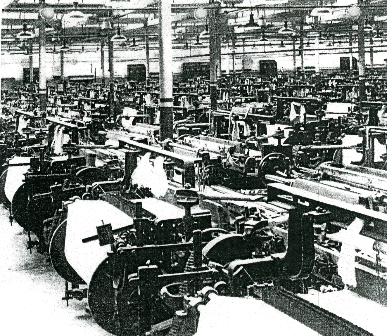
Photograph
of Bank Mill Loom Shed Where Each Weaver Operated 8 Looms
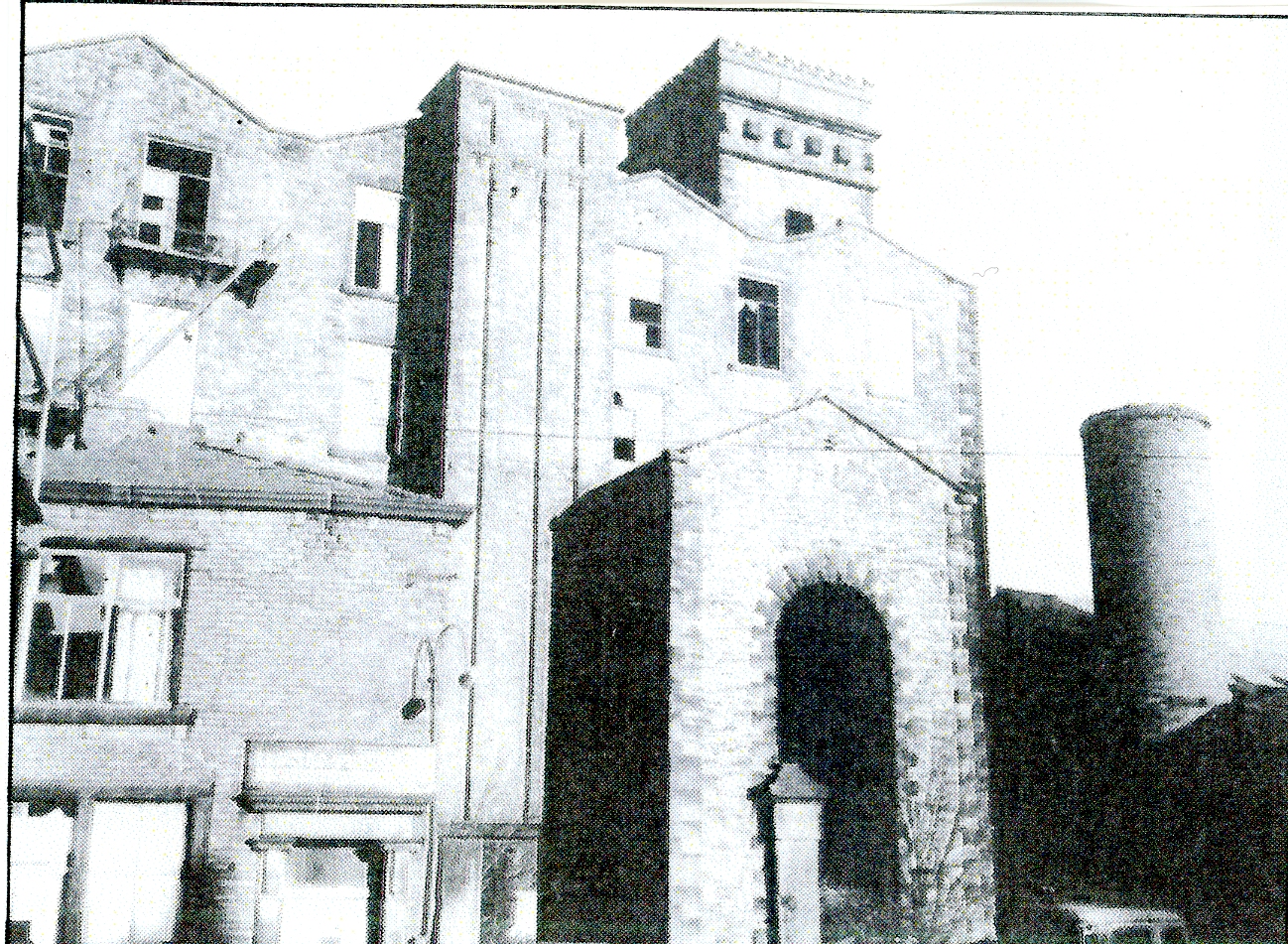
West
Gable of Bank Spinning Mill with the Engine House and Chimney Base
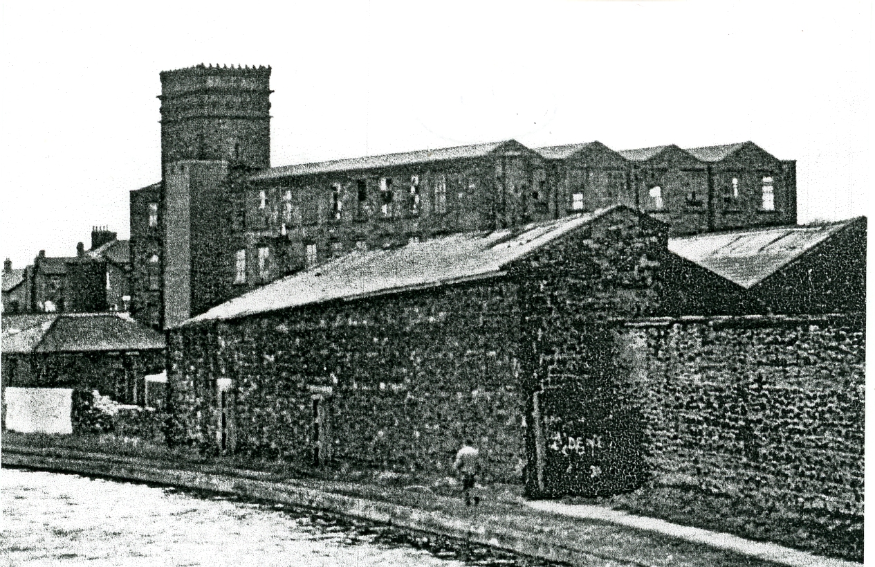
View
of Bank Mill Complex From the Leeds Liverpool Canal
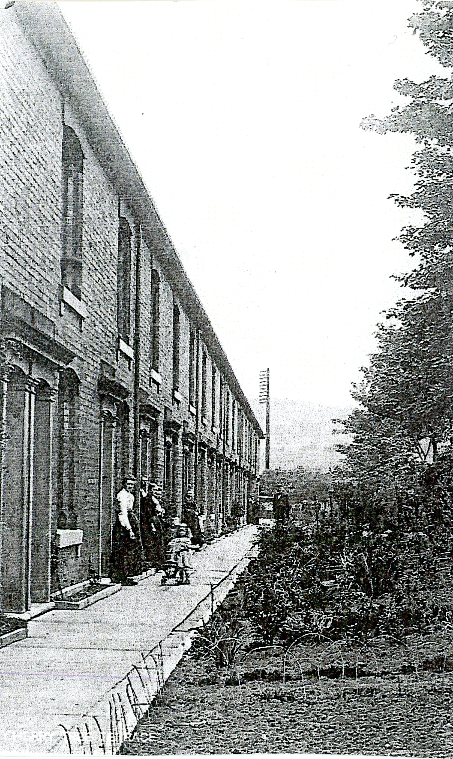
Early
1900’s Photograph of Cherry Tree Terrace Built for Bank Mill Operatives
Dugdale Family History
John Dugdale whose youngest son, Joseph, was born in 1839,
was an iron founder working at Bank Foundry, Eanam, then owned by Joseph
Harrison and Sons. In 1872, the Harrisons gave up the business and John Dugdale
bought up the patents, patterns and goodwill to continue the business at Soho
Foundry based at Salford/Eanam. This was an important link to the loom-making
trade as the foundary made textile machinery for the local area. John Dugdale
as head of the business lived with his wife Alice, near the foundry, at Eanam
house; he died in 1870 and the family firm continued as John Dugdale and Sons.
His son, Joseph Dugdale, became head of John Dugdale, Harrison and Willan
Textile Mills together with Dickinson’s Foundry at Bank Top. He had entered his
father’s business and showed a passion for detail that helped the firm’s future
development. Joseph married Ann, the daughter of William Birtwistle (another
textile magnate) which proved a very fruitful alliance.
Another Dugdale of note was Thomas Dugdale, a qualified
doctor, descended from ancestors in the Great Harwood area and, on retiring
from his medical role, acquired valuable estates in Witton and Livesey formerly
belonging to the Boardman family of Cherry Tree. He then went into the textile
business building cotton mills especially in the Mill Hill area where he lived
with his wife at Griffin Lodge.
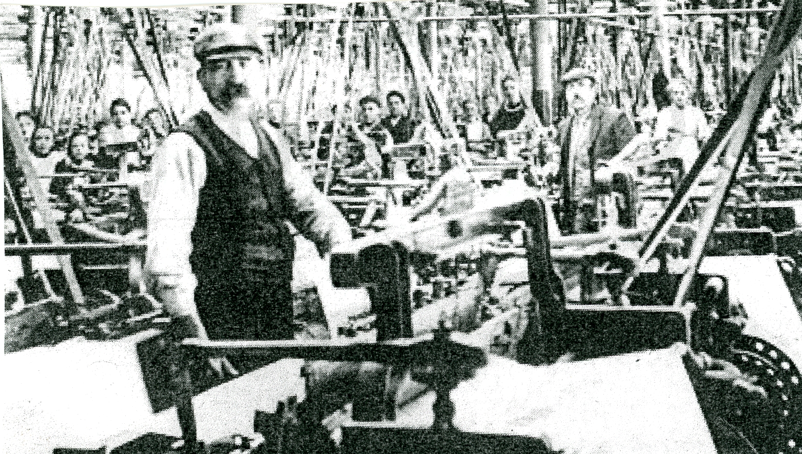
Early
1900’s View of a Typical Weaving Shed with
Operatives and Overlooker Present
George
Whiteley
In 1852 George Whiteley came to Blackburn from Halifax to
learn the textile trade as a partner of Joseph Eccles at his Mill Hill Mill and,
in 1856, he established his own large textile mill at Albion Cotton Works at
Ewood. However, the ever increasing pollution of the River Darwen in the Ewood
area led him to move house to a more rural spot in the 1860’s when he built a
new house next to the Preston-Blackburn Turnpike (Preston Old Road), close to
Livesey Hall, near the edge of Cherry Tree called Woodlands. He lived there
till his death in 1873; his widow and eldest son continued to live there. Later,
his brother James moved into the house but the Whitely Brothers then moved into
politics and left the area so Frank Longworth moved in who was also a cotton
magnate of the Walpole Street Mill in Blackburn and he lived in the house until
1932. During the 2nd World War the house became an army depot, and
later, was converted into four flats which were occupied till 1970 when the
building became empty and dilapidated; eventually, it was turned into a nursing
home. The building itself was a listed Grade 2 site having a hipped slate roof
with the front of the building having four applied Tuscan Pilasters and a stone
modillion eaves cornice. Its central doorway was made up of Tuscan Pilaster
with a fluted round arch and keystone and cornice. All the windows of the house
had stone frames with wings and sills as shown in the photograph below.
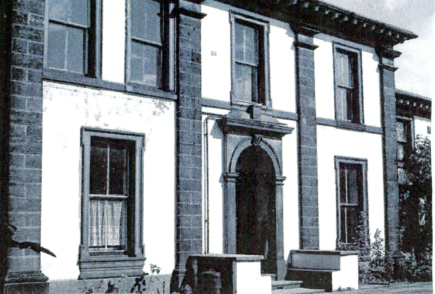
Woodlands
House Frontage in the Cherry Tree Area
Cherry Tree Machine Company
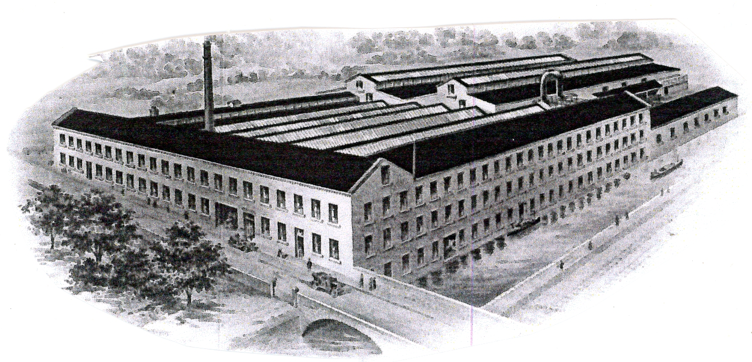
Sketch
Showing the Extensive Works of Cherry Tree Machine Company
in Early 1900
Another significant industrial development in the growing
Cherry Tree area was the Cherry Tree Machine Company built to the south of
Cherry Tree Cotton Mill, above the Tannery, on the banks of the Leeds Liverpool
Canal in 1870. By 1997, they were classified as one of the largest established
engineering companies in the north of England. The company specialised in the
manufacture of industrial laundry machines for countries around the world. In
the early days, their products were made for such places as Workhouses,
Prisons, Institutions, Hospitals and Municipal laundries. At this time, each
machine was largely constructed of timber and cast iron and was manually
operated. The Company remained on this site over its lifetime, although
extended several times, growing eventually to cover an area of 100,000 square
feet of manufacturing and office accommodation. Its site by the Leeds Liverpool
Canal was originally for a source of water for steam power and the need of
barge transport for heavy raw materials required by the Company, such as coal,
pig iron and timber, which could be unloaded directly into the works and to
take the finished products to Liverpool docks for onward journey. As the company
was also situated close to the Cherry Tree railway station, many laundry
machines could be transported to home markets or ports. The Company had a yard
adjoining the canal where quantities of pig iron could be stored with two
cupolas (furnaces) producing molten metal for the foundry.
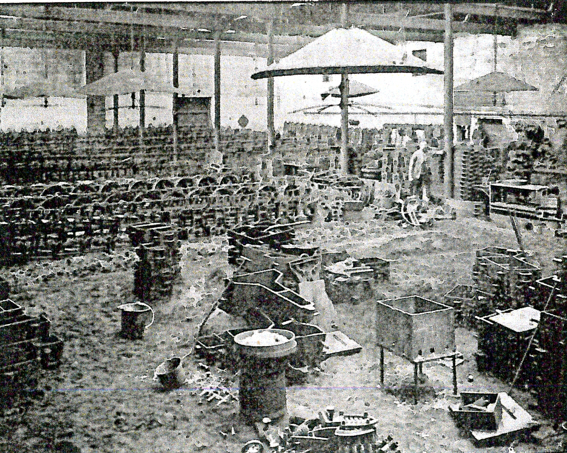
Internal
Photograph of the Company’s Foundry with Moulds on View
The moulding shop was 120 feet long and 80 feet wide
where various castings for its machines were made and, in the fettling shop
next door, the castings were cleaned, sorted and stored to be taken when
required to the erecting and fitting shops; there was also a smithy nearby
where large amounts of bar iron and steel were stored. In the smithy, springs
for wringing and mangling machines were produced, using cutting and punching
machines with steam hammers operated to form the ends of roller shafts. Timber
requirements included maple, pine, sycamore or spruce from America which was
cut into various lengths, bored, roughly turned and then stacked to allow
seasoning. Due to the large number of machines produced annually, 70,000 roller
blocks were required to meet the orders.
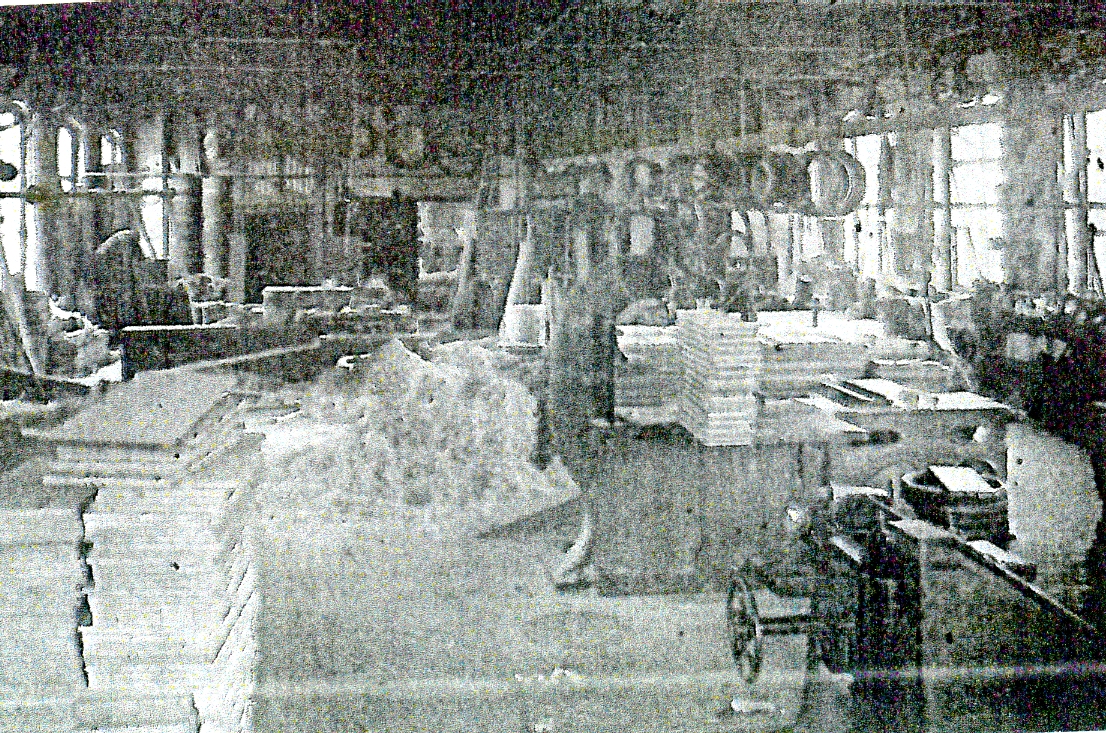
The
Wood Working Department at Cherry Tree Machine Company
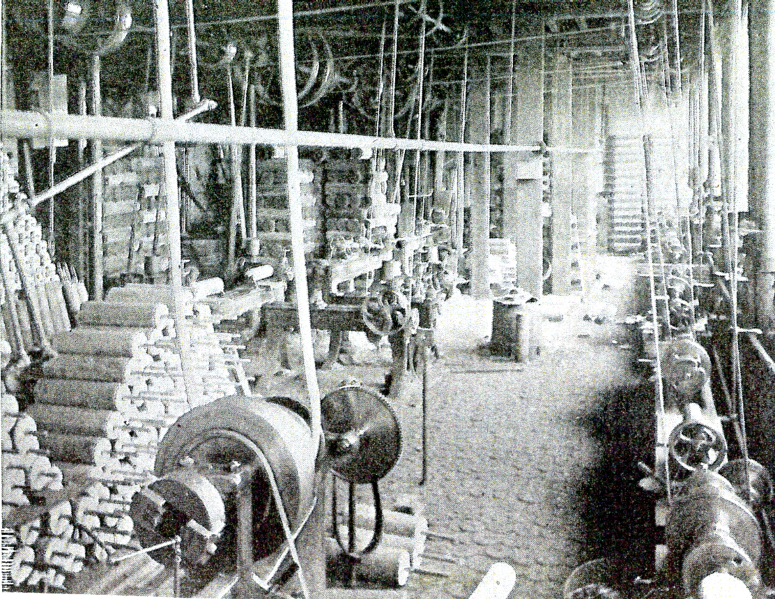
The
Wooden Roller Finishing Room at Cherry Tree Machine Company
Wood turning was important and carried out in a special
department with a variety of machines used to create tubs and rollers for
washing machines, dollies, mangling boards, water boards and handles together
with various domestic products including step-ladders and sack trucks.
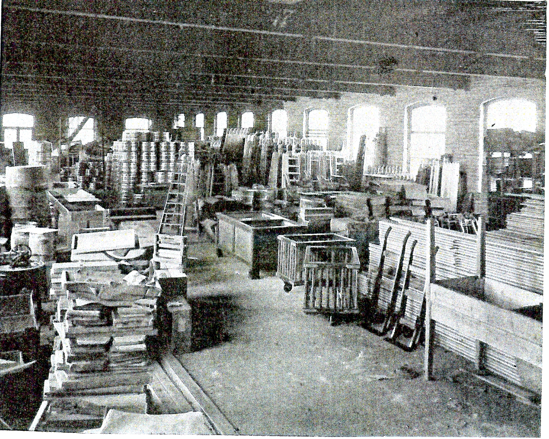
The
Store Room at Cherry Tree Machine Company
for Finished Woodwork Products
All the machinery in the factory was made using a large
horizontal beam engine with another horizontal beam engine and boiler used for
the cupolas. A large machine and erecting shop was the place where the machines
were assembled, painted and finished prior to being delivered to customers.
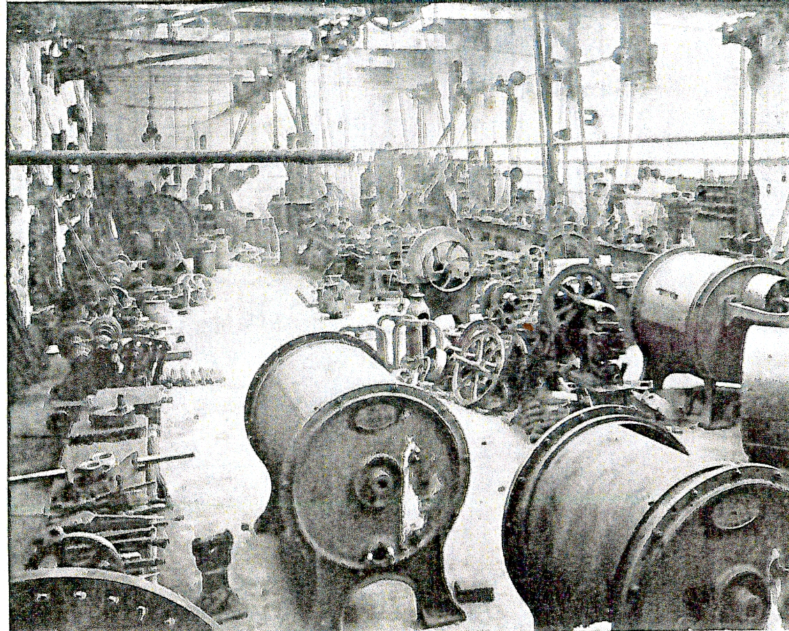
Photograph
of the Machine and Erecting Shop
At one time the company had over 2000 customers all
requiring their own name on the machinery they bought. Originally, the main
products manufactured were the patented Queen, Model and Cherry Tree Washing
machines (as used by the Royal Laundry) with a large variety of styles of
mangling and wringing machines.
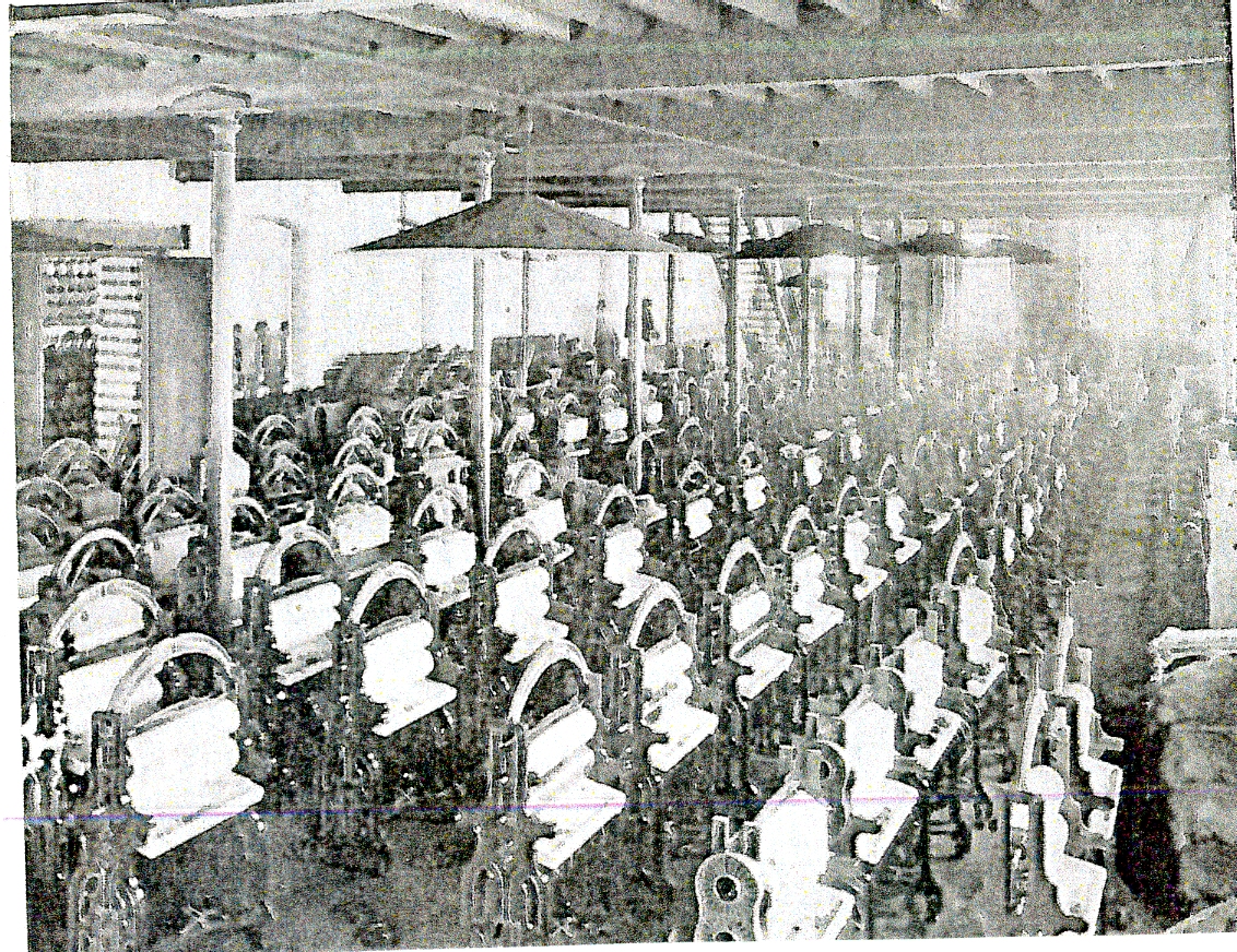
Photograph
of the Fitting Room for Mangles
The original directors of Cherry Tree Machine Company were
Mr. T. Mercer and Mr. T. Woodfall. As laundry products advanced the company set
up new departments for products such as ironing machines and supplied
workhouses, hospitals, infirmaries and hotels together with the new public
baths. One of Cherry Tree Machine Company’s great strengths was that their
machines were built entirely by their own skilled workforce so raw materials
entered the factory and finished goods left. Over the years, the Company’s
market place and customer base changed dramatically and the complexity of their
machines had to grow accordingly to meet the needs of textile and denim
factories and schools. In more recent times, over 50 types of heavy duty
washers, extractors and commercial spin drying machines were produced, some
weighing up to 50 tons.
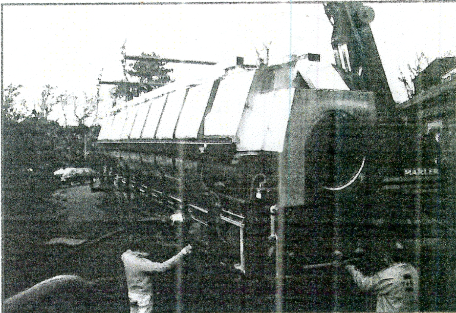
Photograph in 1994 of a Continuous Batch Washer Machine
being Exported to Italy
As a consequence of changing markets, the company had a
research and development department with a team of mechanical and electrical
engineers to travel all over the world as markets expanded into Africa and
Asia. In more recent times, as markets reduced, the company was forced to close
its Cherry Tree works which remained unused until the site was demolished for a
new housing estate. The company then moved to a much smaller modern unit in the
Greenbank area of Blackburn where they now carry out servicing of existing
laundry equipment.
Image
Cherry
Tree and Feniscliffe Areas From 1893
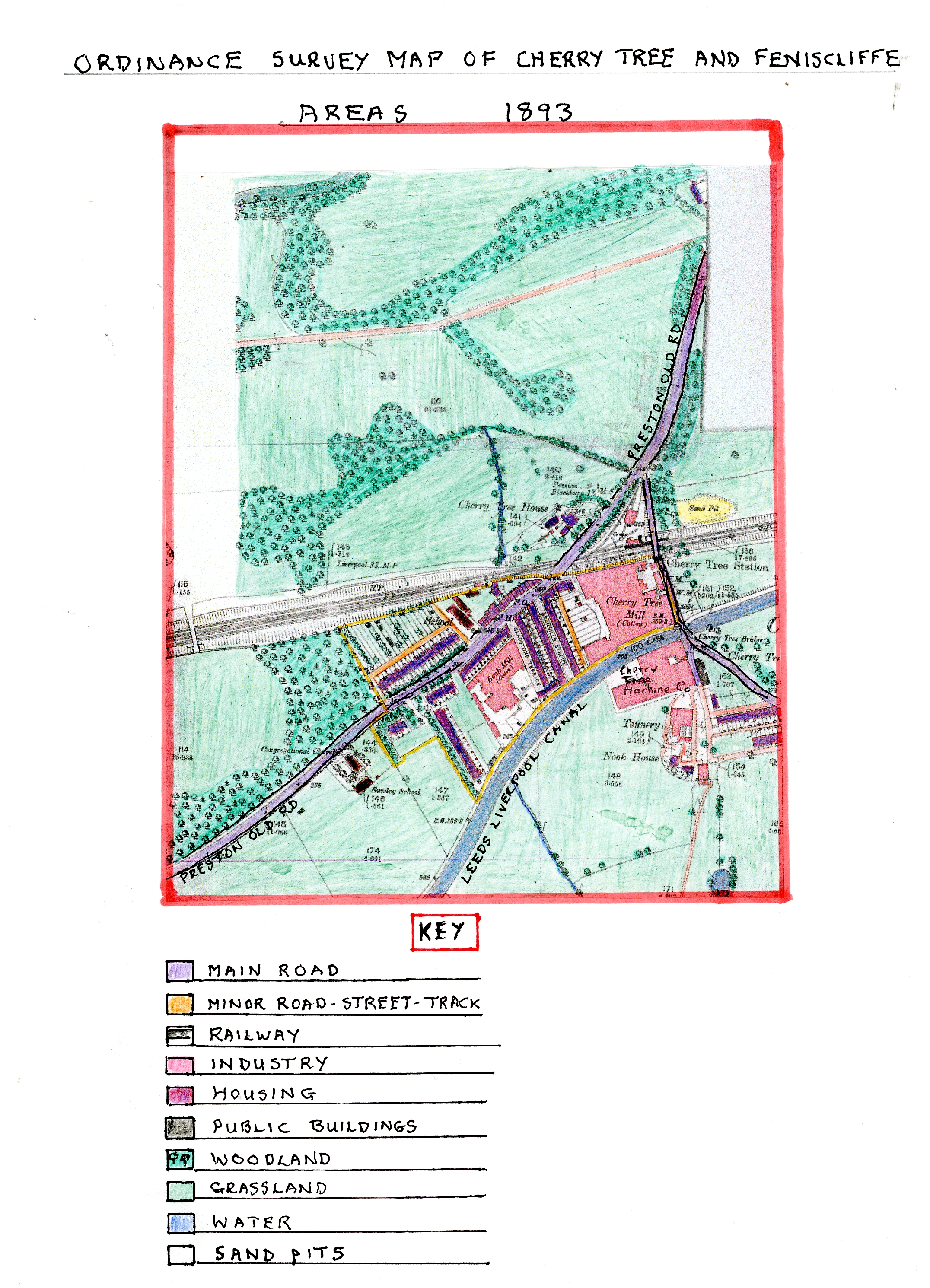
Ordnance
Survey Map of Cherry Tree and Feniscliffe
Areas in 1893
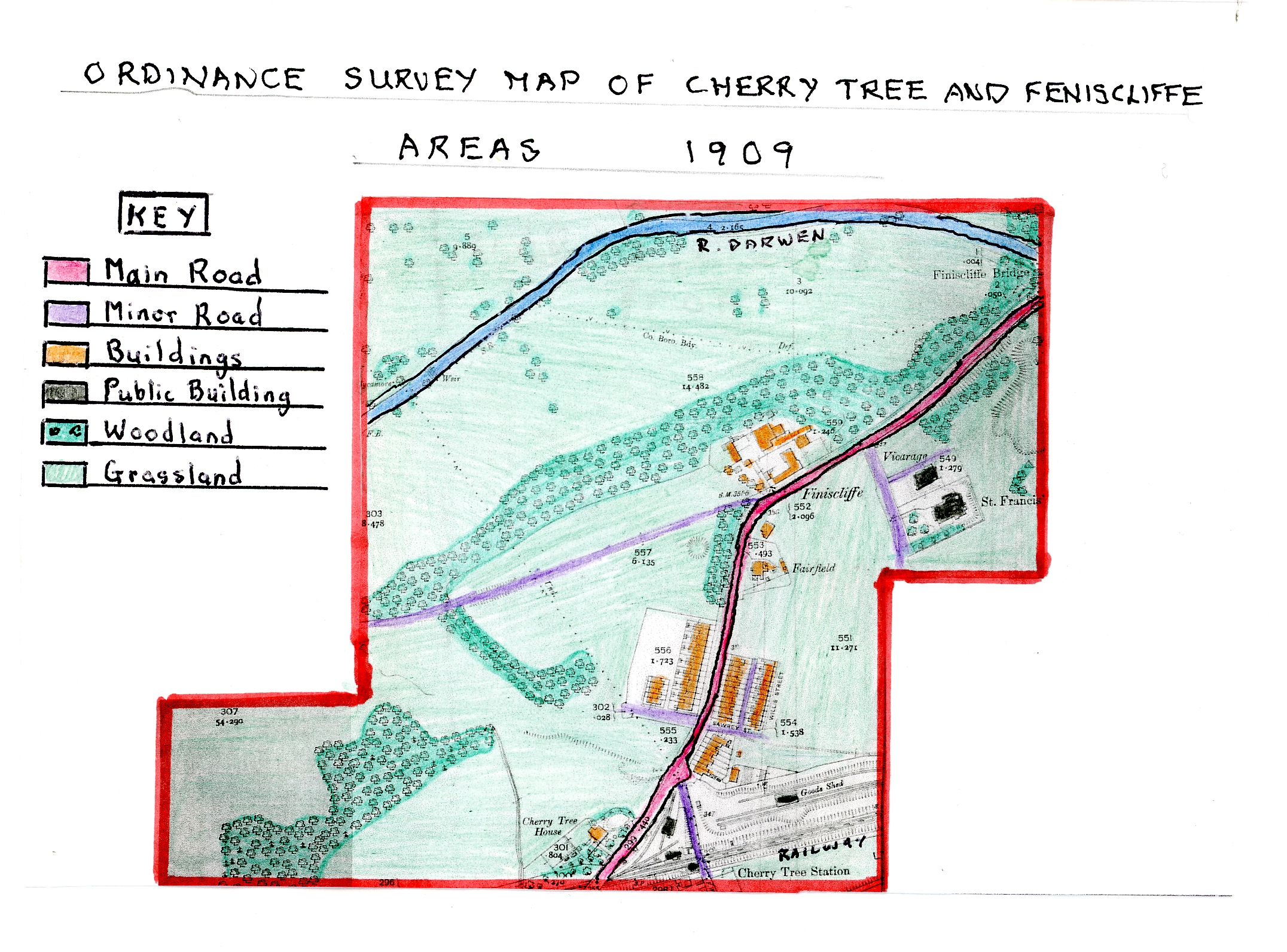
Ordnance
Survey Map of Cherry Tree and Feniscliffe
Areas in 1909
Both these maps show there has been little development in
the Feniscliffe area since 1848 (a period of 45 years) but major changes to the
central Cherry Tree Area. Cherry Tree Textile Mill has now grown larger, Bank
Textile Mill has been built on a former green field site, close to Cherry Tree
Mill, along with new mill terraced housing (see details earlier). The new
terraced housing alongside Preston Old Road, built in the 1880s, is depicted
with allotment strips up to the edge of the railway as gardening and growing
vegetables had now become popular. Alongside the main road on the opposite side
to Bank Mill a row of shops had developed with an odd house and the public
house called “The Bee Hive” with a further public house built near the bridge
over the railway called “The Station Inn”. These public houses indicate how the
growing population in the area created a market for their service needs.
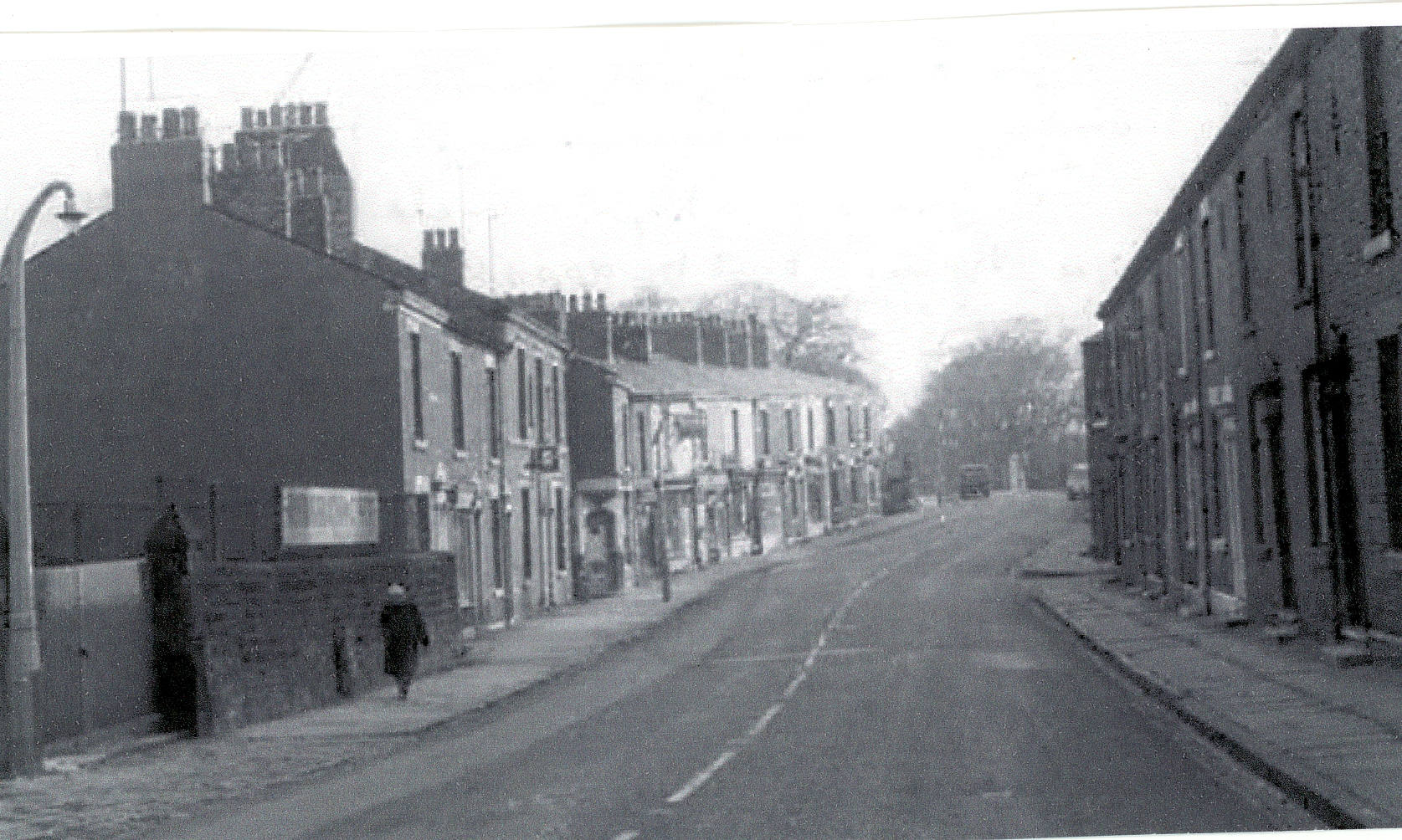
Photograph
Showing the New Terrace Shops Including
The Bee Hive Inn with the Terraced Houses of Bank Mill Opposite
and the Stone Wall of Cherry Tree Congregational School Yard.
Another significant development was the building of
Cherry Tree Machine Company on another green field site on the south side of
the Leeds Liverpool Canal opposite Cherry Tree Textile Mill (see details
earlier), close to the existing Tannery which had also grown larger. By the
side of the Tannery was an existing, older, large detached house called Nook
House, probably the residence of the Tannery owner. Cherry Tree Railway Station
and its platform are now fully developed as are the small goods yard and engine
house; the railway was now used more regularly by the nearby residents and
industrial concerns especially as steam powered engines and railway stock had
greatly advanced. The railways extensive cuttings both east and west of the
station, shown on the map, indicate how the railway builders had to cut down
into the land here to maintain a relative flat route to Blackburn and Preston.
By 1893, the population had greatly increased in the
Cherry Tree area leading to improved communication links by the railway and the
local roads. Road surfaces were improved to accommodate the increased horse and
cart traffic with cobbled sets popular for new street developments. As Cherry
Tree and Feniscliffe were outside Blackburn Borough, which had also expanded,
there was a growing need for locals to commute to Blackburn market and shops
together with work opportunities. As a result, a tram system expanded, firstly,
to nearby Witton Stocks in 1899, and then, further extended to Cherry Tree
centre in 1903 when it was electrified to meet an expanding middle-class suburban
area where a new lower middle-class had now settled. This in turn led to an
increase in the suburban ribbon type housing along Preston Old Road tram route.
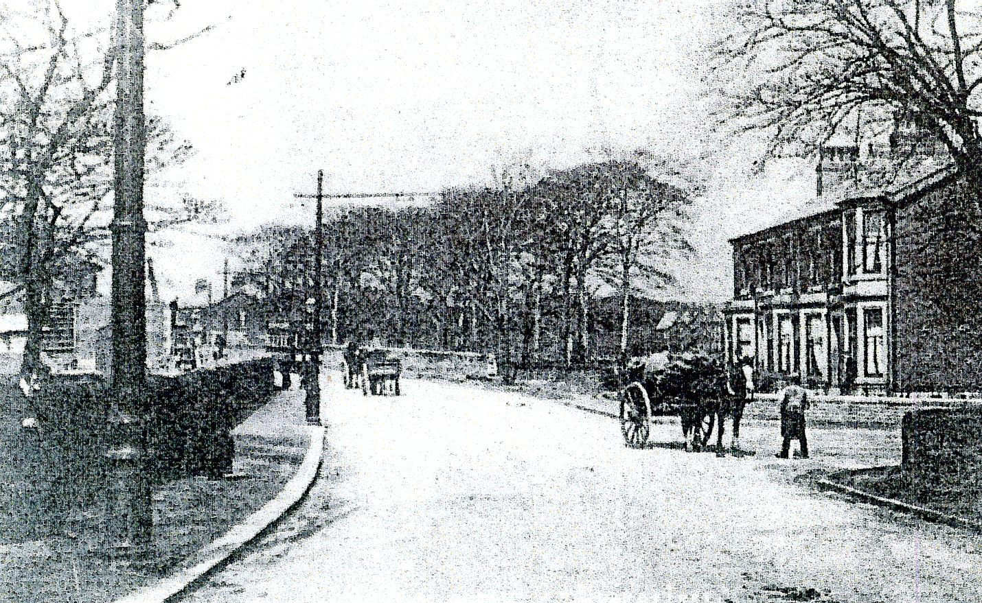
An Early
View Looking Back to Cherry Tree Tram Terminus with a Small Row of Terraced
Houses by the Junction with Green Lane Which was Later Extended. The Line of
Trees Past the Junction were Removed at a Later Date for Terraced Housing and
Shops.
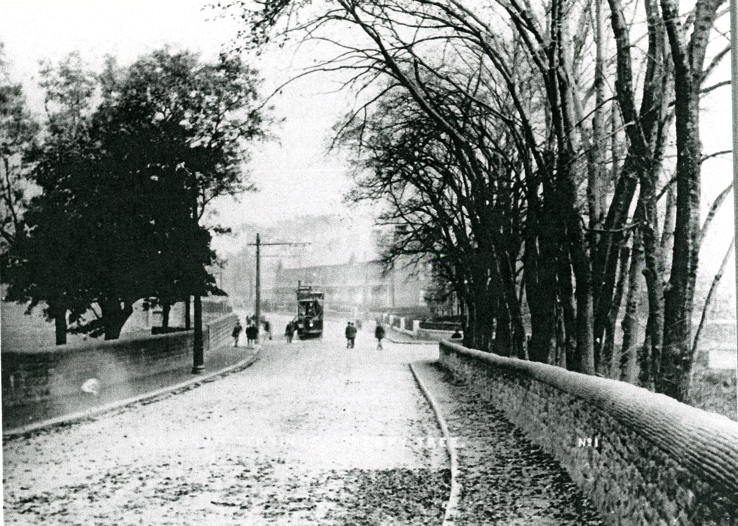
An Early
1900’s View of The Area Looking Down to the Tram Terminus Where a Tram has
Stopped. To the Left Behind the Tree was Cherry Tree House and to the Right
Behind the Trees was Land Leading to Cherry Tree Railway Station Goods Yard.
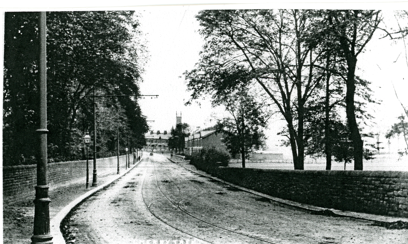
An Early
1900’s View of the Tram-Way Leaving Feniscliffe for the Witton Area
As the tram service became very popular, the tram fare in
1909, from Blackburn Station to Cherry Tree was 1 and1/2d for a distance of
3608 yards. In 1888, there was a royal visit to Witton House in Witton Park
just outside Feniscliffe by the Prince and Princess of Wales who later became
King Edward V11 and Queen Alexandria. They stayed with the Lord of the Manor of
Blackburn Lieutenant General Feilden for an hour after first arriving at Cherry
Tree Station where the platform had been specially raised to stop them having
to step down a couple of feet.
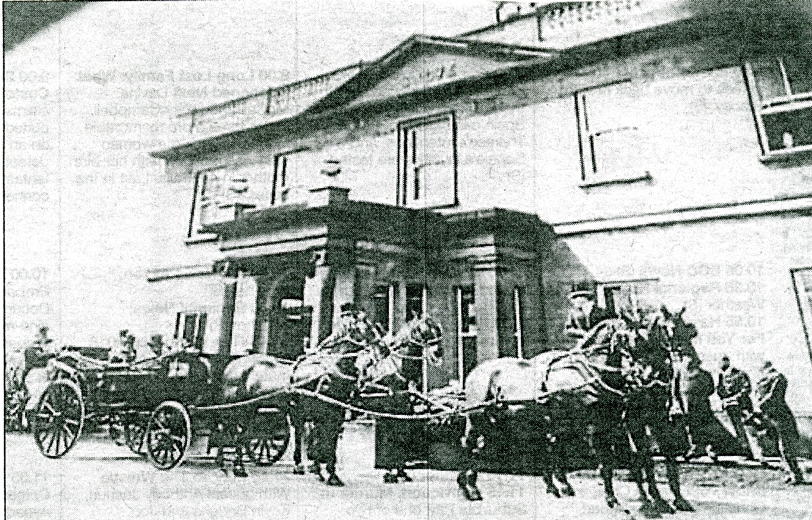
The
Royal Carriage Outside Witton House with Staff Attending
On leaving, the Royal couple were presented with a pair
of clogs fixed on an ebony stand as a gift from the children of Witton School.
The Royal entourage then visited Blackburn in order to lay the foundation stone
of the town’s new Technical College.
The sand pit shown on the 1893 map in Feniscliffe was
owned in 1900 by Enoch Parkington, a sand merchant and general carter who
resided in nearby Witton.
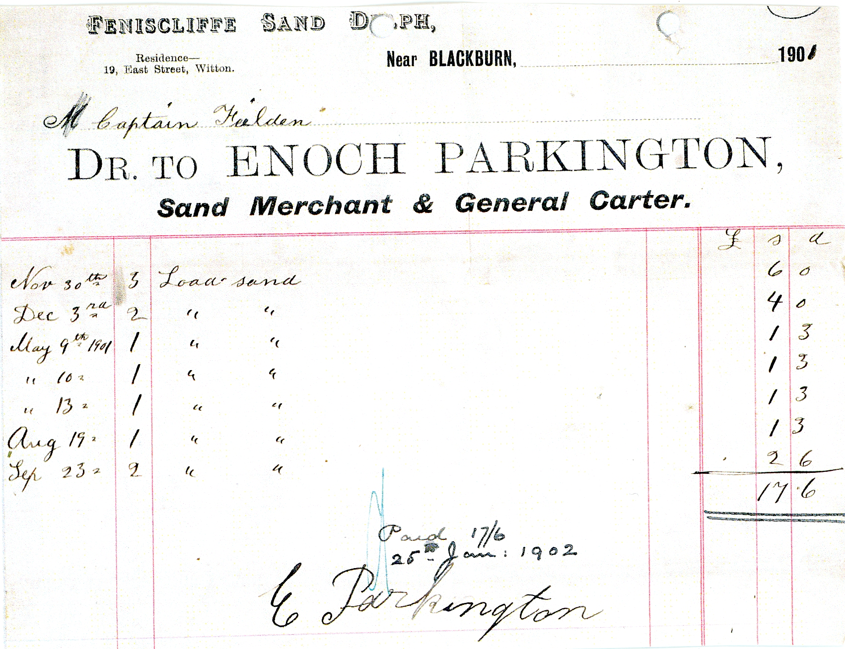
Copy of a Bill Sent to Captain Feilden at Witton House for Sand
Bought from Enoch Parkington of Feniscliffe Sand Delf
Between November 1900 and September 1901
During the same period The Cherry Tree Jam Co. Ltd was formed, operating just outside the area from works near Feniscowles Railway Station where they manufactured high class jams, marmalade, lemon cheese, pickles and sauces
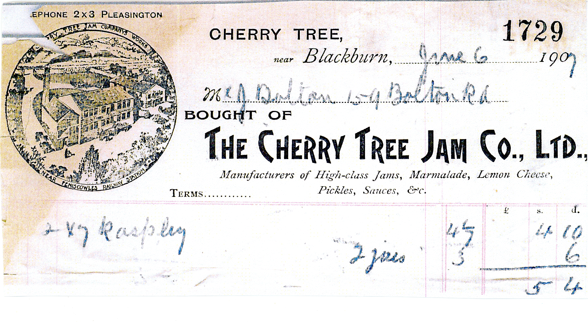
Copy Bill from Cherry Tree Jam Co Ltd to Mr. Dalton of Bolton Road
Just off the 1893 map, to the east of Preston Old Road and north east of Cherry Tree in the Feniscliffe area, St. Francis Church had been built, opening on July 25th 1892 with perpendicular architecture. The foundation stone was laid by Lieutenant General Feilden in 1890, and, when completed, it had a nave, north and south aisles, chancel, chapel, choir and clerics vestries and a church porch. It was built of Brighouse stone with dressings from Cheshire. The nave was illuminated by four windows donated by Lt. Feilden who was also the main contributor to the cost of building the church which was £7000. The church had 500 sittings of which 300 were free and also had a vicarage which cost £2000. Later, a church hall was built next to the church which also acted as a Sunday school venue. The building of the church at this time was to meet the religious needs of the growing population in the area which was now approximately 5,000. Previous to the church being built, St. Francis Iron School had been built in 1889 in nearby Henry Whalley Street, Mill Hill, at a cost of £500 for 350 pupils, operating as a church building at week-ends. In 1896, St. Francis Mission Church opened in Norfolk Street, in nearby Mill Hill, at a cost of £1,200. It was designed by Stones and Gradwell and made up of a chancel and a main room with two classrooms. It was built of brick with terra cotta dressings and part of a larger scheme where it would ultimately be used as a day school to accommodate 250 pupils. A Congregational Chapel was also built by Preston Old Road on the edge of Cherry Tree, opening in October 1887, built in the Gothic style of stone which could accommodate 400 people. The building cost £2,000 and was a gift of the textile magnate Joseph Dugdale. Later, a stone Sunday School and Church Hall was built alongside (see 1893 map). By 1893, it had a school built in the centre of Cherry Tree, also built of stone, for local children, which was also probably provided by Joseph Dugdale. It had a school yard and outbuildings sited just beyond the row of shops in Cherry Tree centre.
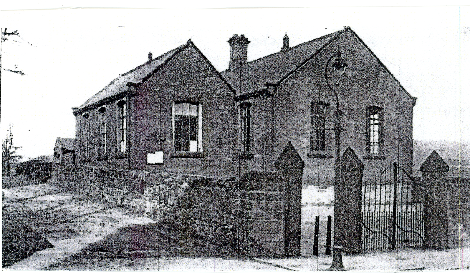
Immanuel/Cherry Tree school built in 1865 to cater for both villages.
Lady Feilden of Feniscowles Hall laid the foundation stone in April 1865
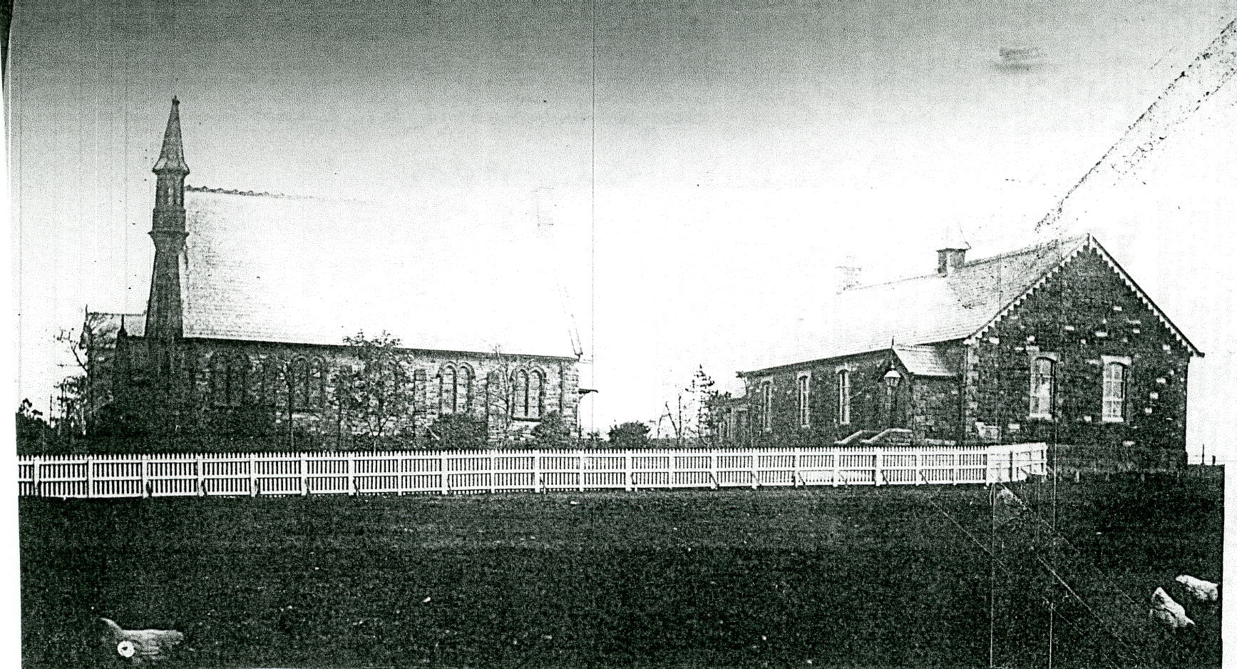
Early photograph of Cherry Tree Congregational Church and Sunday School
The rest of the 1893 map's rural landscape had little changed since 1848 with extensive area of woodland still present.
The 1909 map extract of the northern section of the area, especially Feniscliffe, shows clearly that in the 16 years, since 1893, there had been significant growth from the railway station northwards, with new terraced housing stretching along both sides of Preston Old Road to meet the needs of local workers and commuters with the growth of the lower middle classes. At Finiscliffe itself (Feniscliffe) a large detached house called Fairfield together with another detached property had been built. Feniscliffe Farm had by now grown much larger with extensive outbuildings including a barn for cattle and farm machinery which was by now more extensively used, mostly steam powered, with cottages for farm workers. The extract also shows St. Francis Church and vicarage. Looking towards Cherry Tree Station can be seen a more extensive goods yard on the strip of land alongside the railway line indicating the growing needs of local industrial sites. These new developments required the removal of extensive areas of woodland and a sand pit.
Cherry
Tree And Feniscliffe Areas From 1932
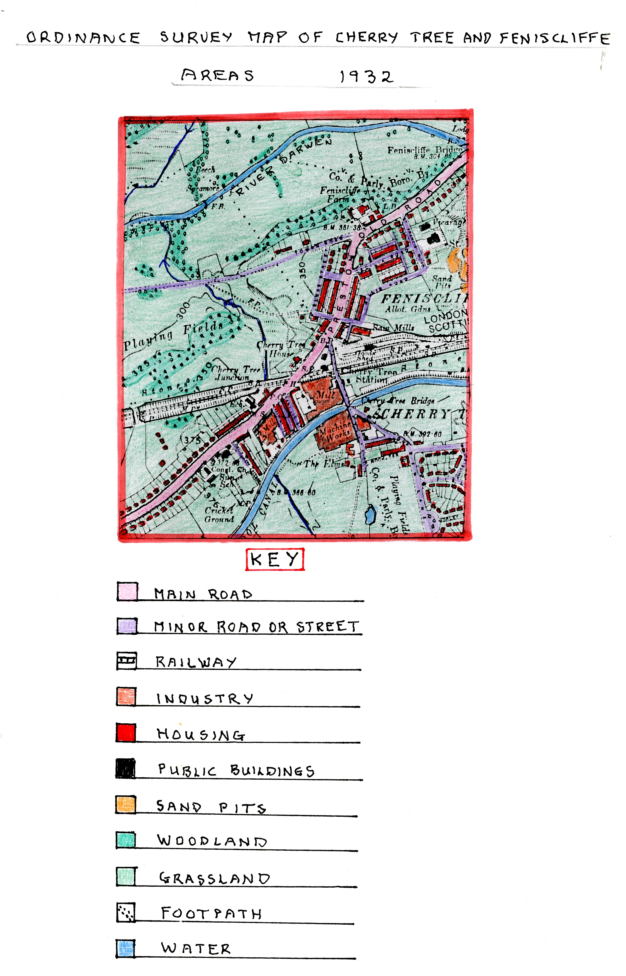
Ordnance
Survey Map of Cherry Tree and Feniscliffe Areas
in 1932
During the last 23 years, including the 1st
World War period (1914-1918), the map indicates that many significant changes
had occurred, with growth in all parts of the area due to a variety of new
developments. The largest change is the growth of new housing especially in the
Feniscliffe area where there was more room, leading to rows of new terraced
housing built in the earlier 1910-1915 period alongside Cecilia Road, Willis Road
and beyond the tram terminus northwards of the tram terminus.
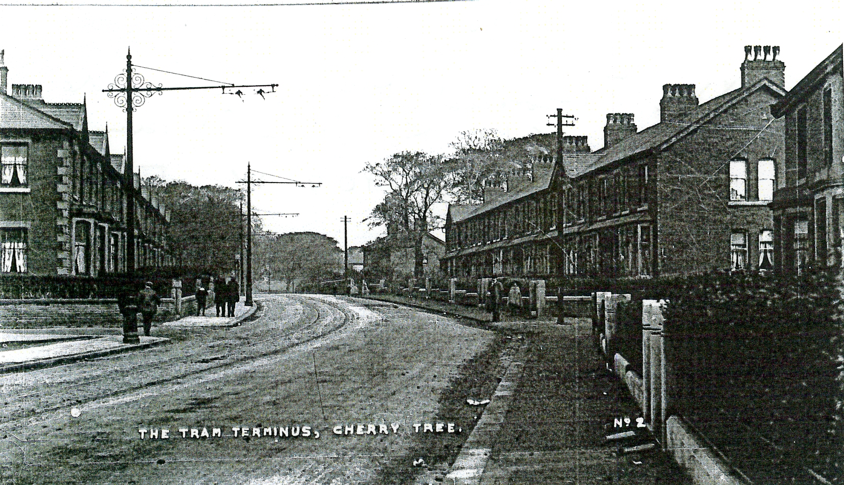
Early
Photograph of New Terraced Housing Built Alongside
Preston Old Road Beyond the Tram Terminus
Additionally, new
rows of semi-detached houses were built in the late 1920’s to early 1930’s
along St. Francis Road, Preston Old Road and Banes Street with others started
along the top end of Tower Road which had been upgraded from a former track
leading down to Pleasington Fields and beyond. On the other southern side of
Cherry Tree, new, mostly semi-detached and odd detached houses had been built, stretching
out in a linear fashion along both sides of Preston Old Road leading towards
nearby Feniscowles. All these semi-detached properties had front and rear
gardens providing new opportunities for gardeners
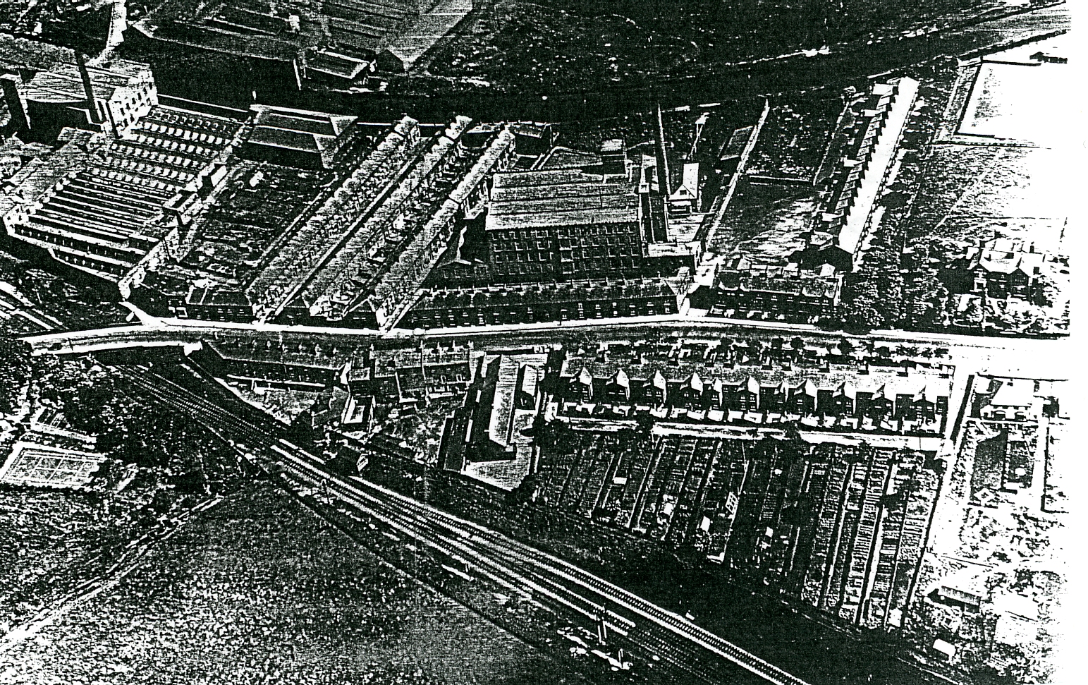
1930’s
Arial Photograph of Preston Old Road Passing Through Cherry Tree with Bank Mill
in the Centre and Cherry Tree Mill to its Left and the Railway Running Along
the Bottom of the Image. The Terraced Houses are Packed Close Bye with Those Sited
Next to Cherry Tree School Having Long Strips of Allotments Running Down to the
Railway.
Another new development was the building of a council
estate in the south-east section of the area with its boundary with Mill Hill
and Livesey. This was the first time the council entered the housing market in
order to develop out of town sites to re-house people from former slum terraced
housing areas demolished in Blackburn. Here, they were offered semi-detached
houses with gardens on non-industrial sites which were a huge improvement and
allowed them to rent more up-market housing. By now, Nook House, in this same
area had been renamed “The Elms” probably because the original tannery had now
closed although its name lives on with the terraced property along Nook Terrace.
Existing large scale textile and laundry machinery production continued to
develop on existing sites (see photographs below).
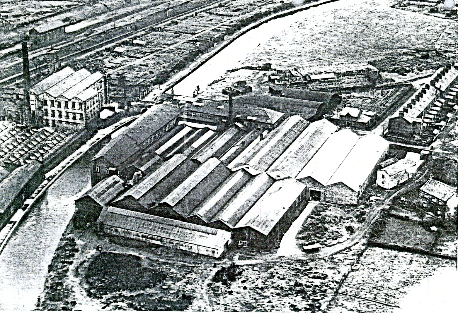
Photograph
of Cherry Tree Textile Mill to the Left of the Canal and Cherry Tree Machine
Co. to the Right with the Railway Line and Sidings in the Top Left and Nook
Terrace on the Right Opposite Cherry Tree Machine Co.
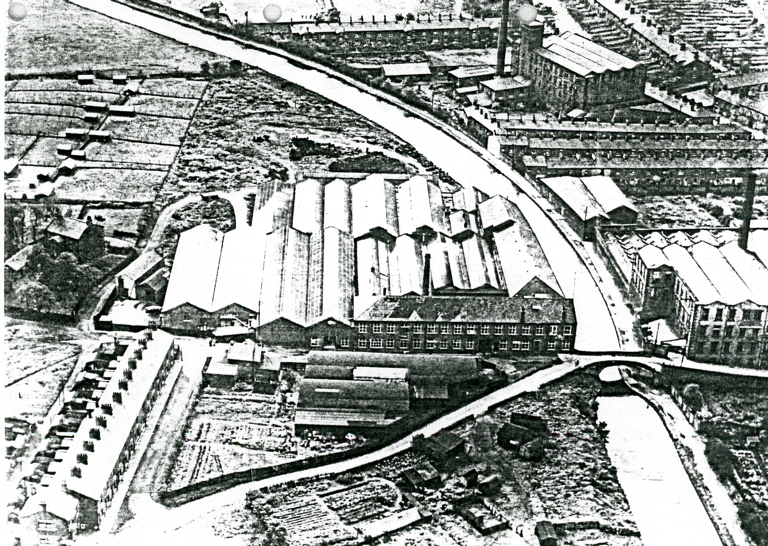
Photograph
Showing the Two Mills with Bank Mill at the Top of the Image with the Canal Bridge
Taking the Road to Livesey- Mill Hill Passing Nook Terrace.
A new industrial development in Feniscliffe was the
development of a saw mill close to the railway sidings being an indication of
the growing need for timber products for local house building in the area as
was the development of the sand pits shown on the map.
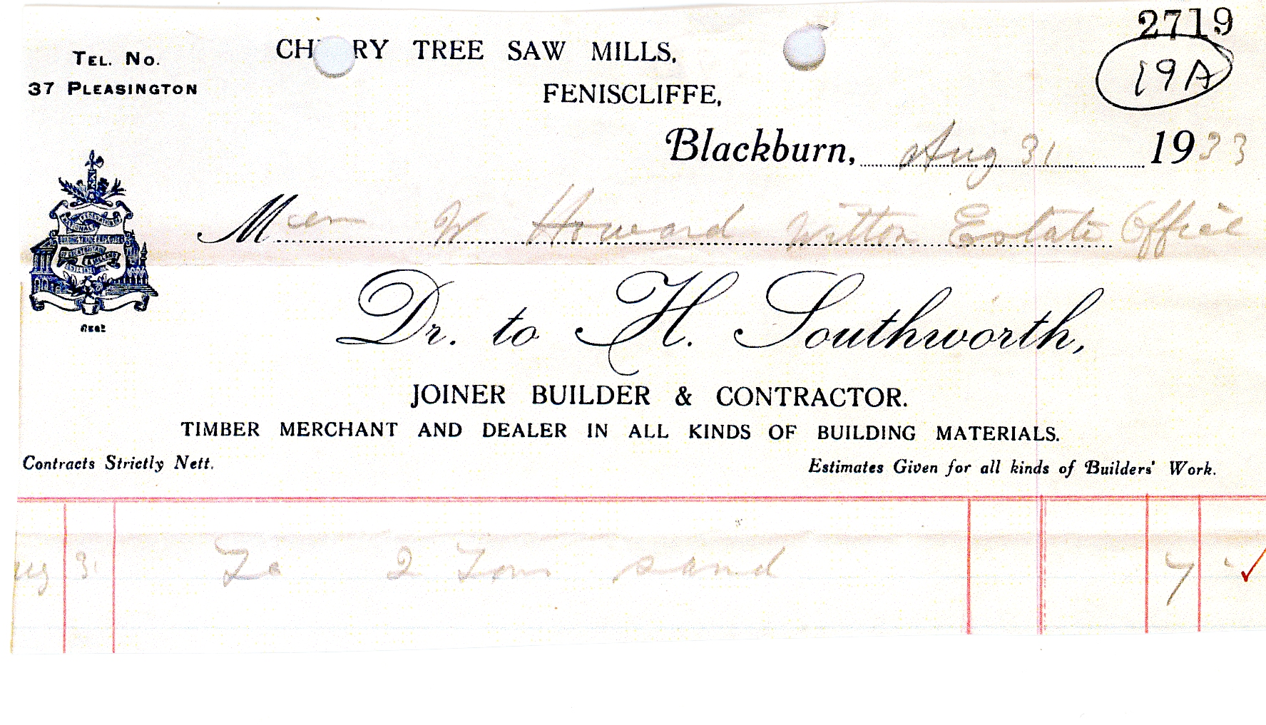
Bill
Head from Cherry Tree Saw Mills and its Owner H. Southworth
Sent to the Witton Estate in 1933.
By now Cherry Tree House had fewer outbuildings probably
because it was no longer a working farm but a private house as it now had a
tennis court.
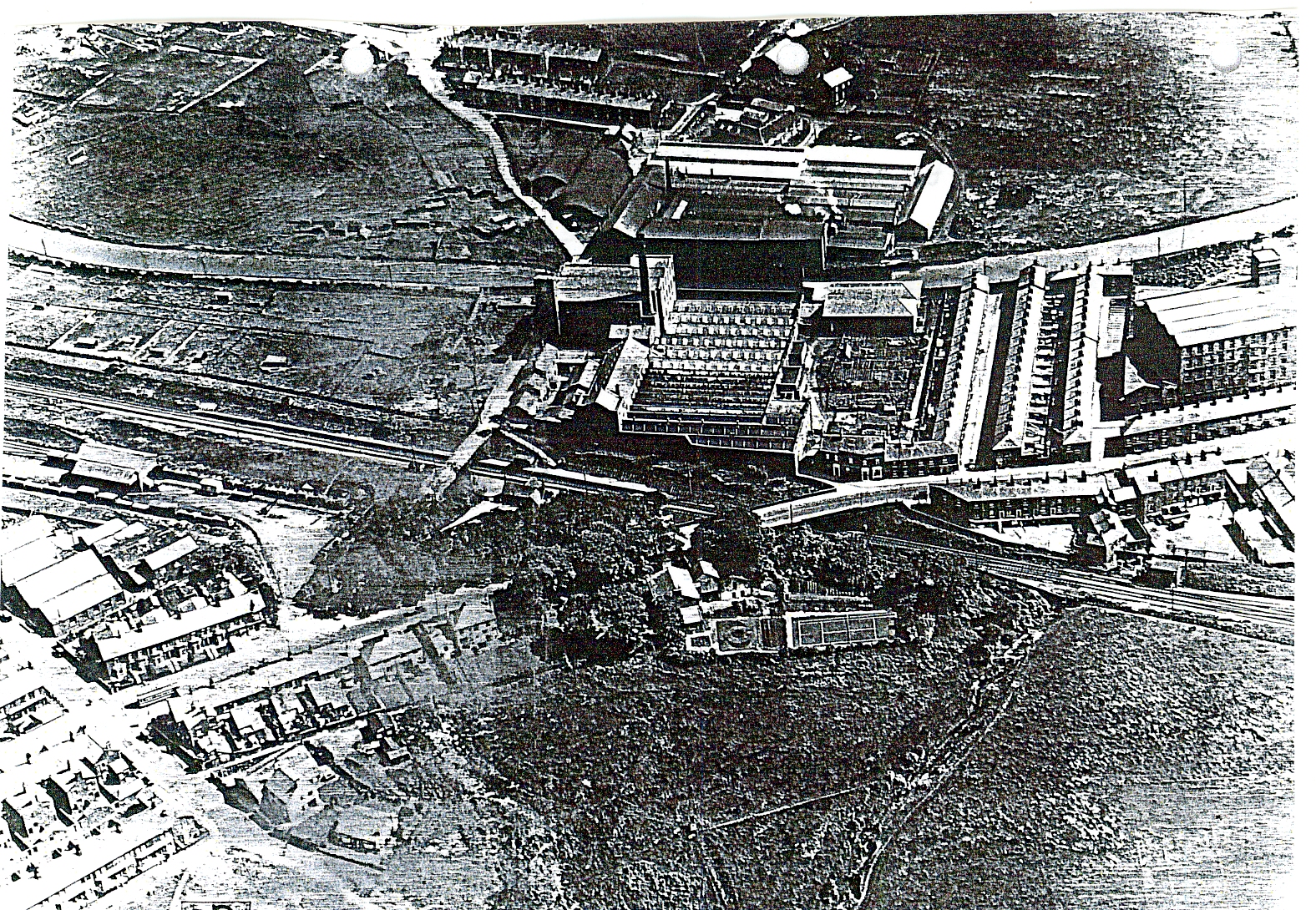
A
1930’s Photograph Which Shows Cherry Tree House in the Foreground and its Tennis
Court. To the Left of this Next to the Railway Sidings are the Saw Mills at the
Entrance to Feniscliffe Drive. At the Top of the Image is the Open Site Where Council
Housing was Built Later.
By now, alongside the tram terminus site, a row of shops
had been built in the 1920’s to provide services for the ever growing
population in the area and tram users.
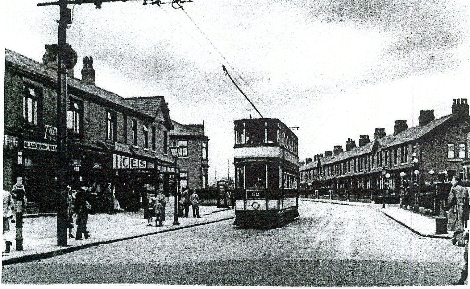
Photograph
of the New Shops Built Alongside the
Tram Terminus at Cherry Tree.
Further evidence of changing local facilities developed
to meet the needs of the increasing population whose working lives had improved,
due to a reduction in hours and more leisure time, was the development of
Council Playing Fields. The playing fields were created next to the newly
developed council estate and the extensive development of Pleasington Playing
Fields with Tower Road providing easy access from Preston Old Road at
Feniscliffe.
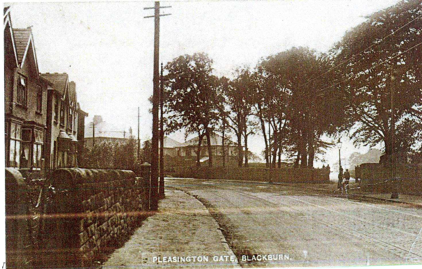
Photograph
Showing Pleasington Gate at the Access Point to Tower Road and
Pleasington
Playing Fields From Preston Old Road and
New Semi-Detached Homes Along Both Sides of the Main Road.
Both playing fields offered extensive facilities for
football and cricket with both also having changing room facilities. Another new
development shown on the map, created on former fields north of the railway
sidings in order to meet the needs of locals living in terraced property
without gardens was the Council owned allotment facility where people could
rent strips of land to grow their own vegetables and flowers. Another sand pit
development had been developed close by as increased building required more
sand. Further evidence of developing local leisure facilities is the
development of Cherry Tree Cricket Club and Crown Green Bowling Club; both shown
on the map, and, developed around Cherry Tree Congregational Church to which
they would have a close connection. Both facilities were developed on previous
open land between Preston Old Road and the Leeds Liverpool Canal. The bowling
green was opened on the 19th June, 1920 by Mr. W. Kay J.P. in the
presence of a large local attendance; Mr Kay bowled the first set of woods. Mr.
Joseph Dugdale J.P. of Cherry Tree donated the land to create the Bowling Club
and he was the first President; the club gifted him an inscribed jack as their
patron. Unfortunately, he could not attend the opening ceremony due to the
recent bereavement of his son. It was declared at the opening ceremony that it
was hoped that before long that ladies would be given an opportunity of
becoming members of the club. Councillor W. Jenkins who had been responsible
for excavating the land to form the green promised to donate a cup valued at
£10. 10s. for a competition as did Mr.Kay. Attached to the green was a pavilion
erected by the members following a subscription of approximately 60 members, at
a cost of £200, which included the purchase of bowling woods. The origin of the
bowling club dates back to the previous year when the secretary Mr. W.
Wordsworth was approached by a number of gentlemen in the village as to whether
it was possible to form a bowling club where men could meet, exchange views and
enjoy bowling. After initial problems securing a site Mr.Dugdale was approached
and he both gifted the land and paid for the green.
Cherry
Tree and Feniscliffe Areas From 1956
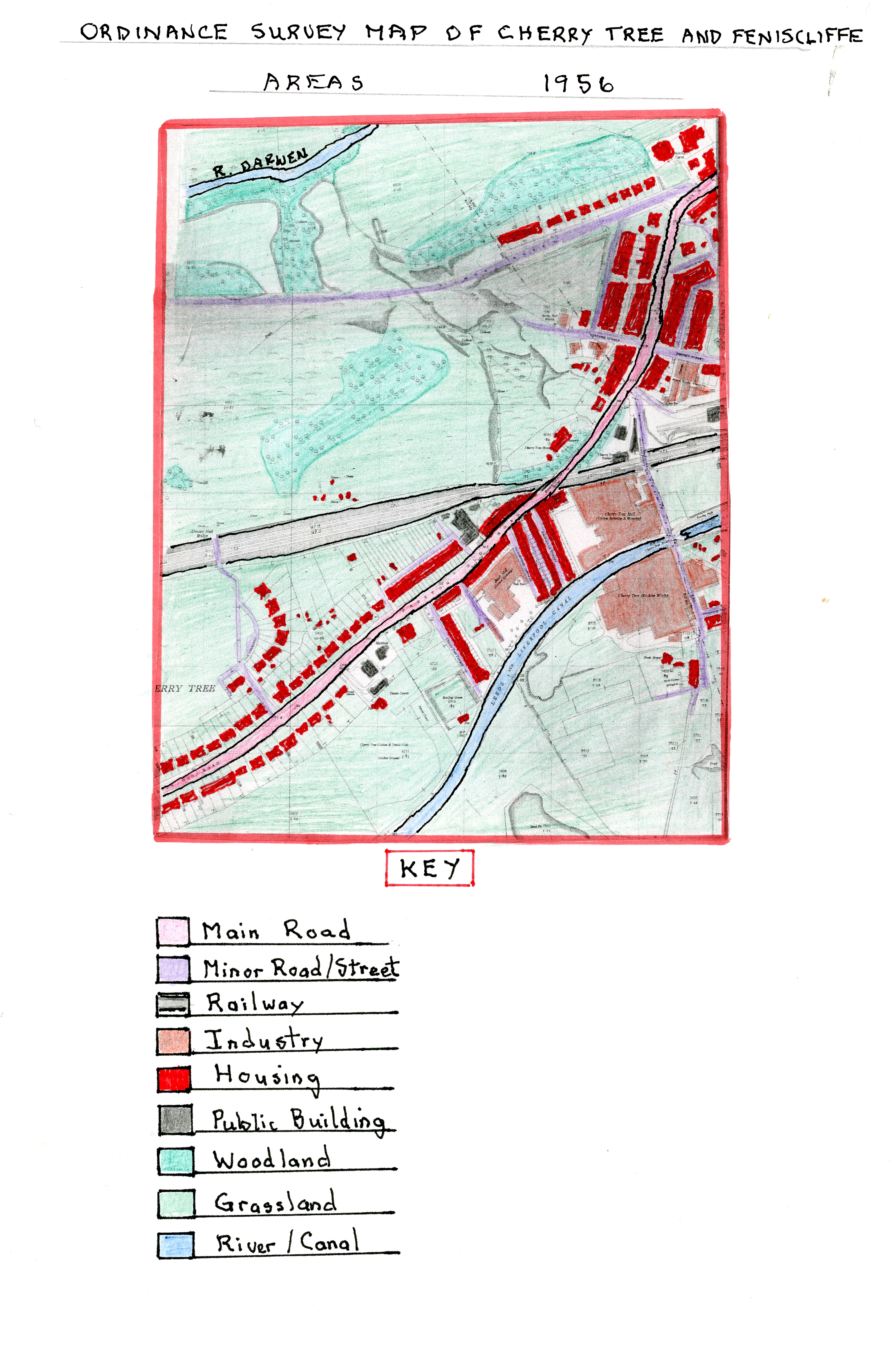
Ordnance
Survey Map of Cherry Tree and Feniscliffe Areas in 1956
This larger scale Ordnance Survey Map shows, in the 24
years since 1932, through the 2nd World War Period (1939-1935), the
new developments in both areas which were not as large as in previous periods.
In Feniscliffe, further semi-detached properties had been built along Tower
Road and new industrial units created off Preston Old Road behind the bus
terminus shops, and also, by the existing saw mill including a garage with motor
vehicles and waggons (now more prevalent), and trams replaced by buses. Public
ownership of cars had by now increased significantly allowing local people to
commute further to work places.
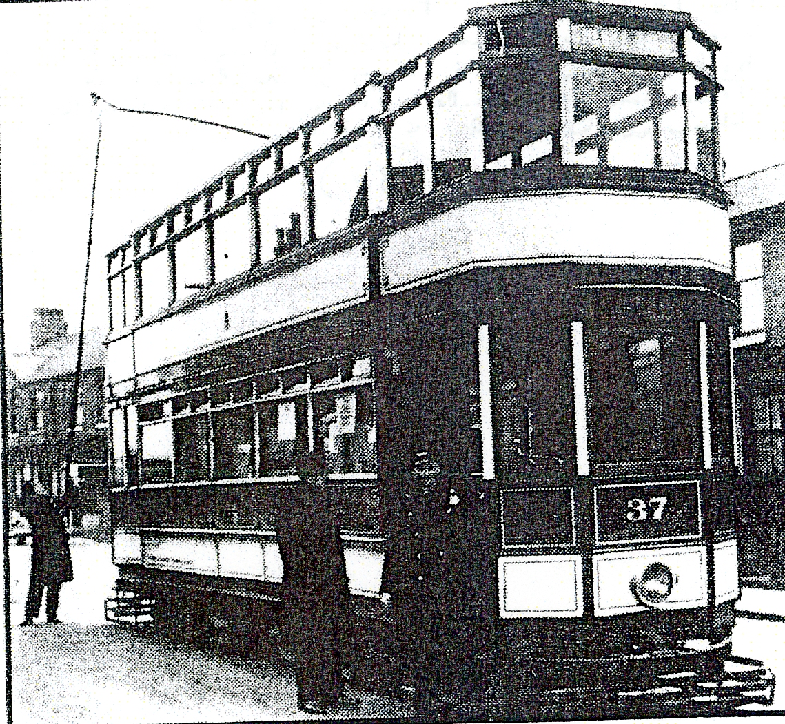
Photograph
of the last Tram Leaving Cherry Tree at 11.25pm Carrying
Members of the Transport Committee and Driven by the
Committee Chairman Councillor C.R. Davies
By now, the railway goods yard had been further developed
and the railway station now had a platform on both sides of the railway and
extra buildings sited by the engine house. Feniscliffe Drive, alongside the
railway sidings, had now been extended round to meet St. Francis Road thereby increasing
semi-detached property in the area and developing the land used for allotments
earlier. On the far side of Cherry Tree, close to the Congregational church, a
start had been made on a post war housing estate off Preston Old Road with The
Crescent. The Council Estate, near Livesey,
had grown much larger, extending to Livesey Branch Road and Shorrock Lane. The
outward development of private mostly semi-detached along with Council Housing
followed a trend in areas outside the Borough boundary in suburban areas like
Feniscliffe and Cherry Tree. This showed the population movement out of
Blackburn centre reversing the migration patterns of the rural to urban movement
in the 19th century as small estates were created in more attractive
areas with better quality housing. The Cherry Tree Cricket Club grounds are now
more clearly defined along with a pavilion and the Bowling Club green now had a
covered side for spectator protection. The cricket ground now had new tennis
courts. Preston Old Road now had a much improved tarmac surface and well
developed footpaths as road transport increased and pedestrian safety became
more of an issue.
In 1955, Cherry Tree Congregation Church’s minister was
the Reverend E. M. Williams who lived close by at the Manse, 336 Preston Old
Road. At this time, the Church Men’s Group organised social events which were
well attended; Fellowship Meeting attendances were also increasing with film
shows and the use of visiting speakers.
Cherry Tree and Feniscliffe Areas up to 2018
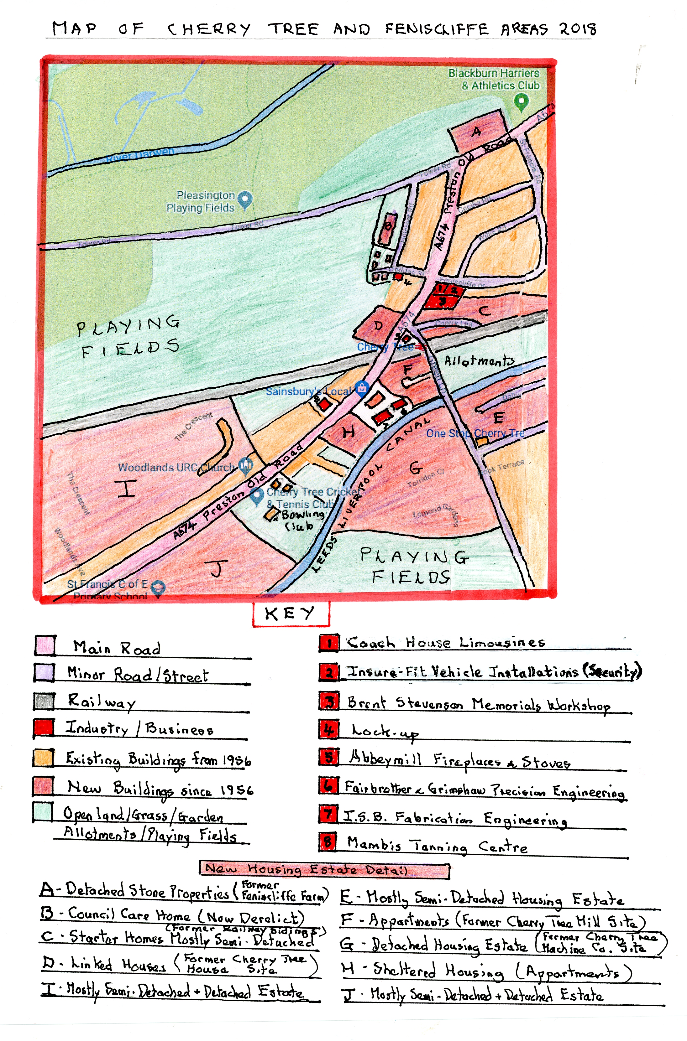
Map of Cherry Tree and Feniscliffe Areas in 2018
Over the sixty two years, since 1956, there have been
huge changes in the area; probably the largest during the historical periods
covered to date. The largest change has been the huge increase in housing and
the comparable huge decrease in large industrial works. I have highlighted the
new housing areas on the 2018 map which includes the Billinge House development
on the old Feniscliffe Farm site with a large detached stone house using
original materials and a new brick built apartment block developed since 2000.
The original railway sidings close to Feniscliffe Drive have been removed and a
small estate of modern starter houses developed and similarly where Cherry Tree
House was sited there are now modern linked properties. Additionally, at the
points where the three large industrial sites once stood there are now modern
housing estates, all built since 2000. The largest of these is on the old site
of Cherry Tree Machine Co. which is almost exclusively made up of various
crescents of modern detached houses linked from Nook Lane. A similar but
smaller estate has been built on the site of Cherry Tree Mill which contains
apartment blocks and two detached houses. The site of Bank Mill now contains
Hunters Lodge, a development of sheltered accommodation for the elderly in
apartment blocks, and, on land between the Leeds Liverpool Canal and Brothers
Street, another estate of semi-detached houses was built in the 1980’s around
Dalby Crescent. Finally, large estates were developed behind the linear
semi-detached housing on both sides of Preston Old Road towards Feniscowles
mostly developed in the 1960/70s containing mostly semi-detached properties but
with some detached and bungalow types. As part of these developments a church,
library and a new St. Francis School were built to provide services for these
new properties in contrast to the more modern estates built since 2000.
On the industrial side the two large textile mills lay
dormant for many years after the decline of textiles in the 1950/60’s and more
recently Cherry Tree Machine Company. On part of the site of the former Bank
Mill two new units were built, one was taken up by Leo’s Carpets which has
since been re-developed into a Sainsbury Local Store and an Air Ambulance
Charity Shop and the other by ISA Engineering Ltd who complete fabrication
work. To the rear of this Fairbrother and Grimshaw Engineering Ltd occupy an
older stone building, a remnant of Cherry Tree Mill where they conduct a
precision engineering business. When Cherry Tree Mill closed the factory was
eventually re-used by Q.S. who acted as retailers for wholesale clothing and
household goods before eventually closing prior to the site being redeveloped
into a housing estate. Cherry Tree Machine Company left their site as trade
declined and re-located to a smaller industrial unit at Greenbank in Blackburn
close to the Tesco store as Cherry Tree Industrial Laundry Solutions servicing
laundry machines. Other than these major industrial changes there are now a
number of small industrial units occupied by a variety of small firms in the
area (see 2018 map key for details) but overall today Cherry Tree and
Feniscliffe are now a major suburban housing area. On the outskirts of
Feniscliffe at its border with Witton an existing huge industrial operation in
Witton formerly Scapa Driers and more recently Voiths developed a new
industrial site on the Feniscliffe side of the River Darwen in 1962/3 at a cost
of £300.000 as an extension for its paper making felts division using huge
looms and also including a department for the research of new felts.
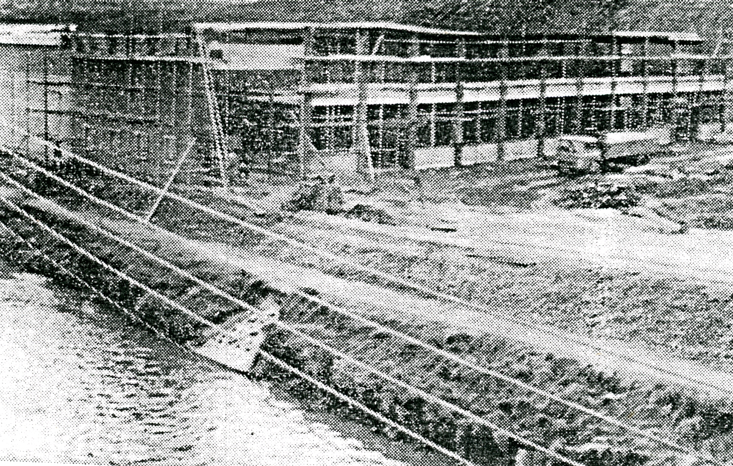
View
of the New Scapa Extension Being Constructed in 1962-3
by the Side of the River
The company has since left the site and this building is
now occupied by M.K.Illumination.
Other developments have been the building of a council
run care home on Hillcrest Road which in recent years has closed and at present
is unused. St. Francis Church Hall in recent years is now occupied by Cherry
Tree Pre- School to cater for younger children of the area whose parents are
working. On the same theme Cherry Tree Cricket Club has extended since being
privately owned in recent times and now has a large membership catering for
local demand for a leisure centre and Cherry Tree centre’s two pubs The Beehive
and Station have been upgraded and unlike in other districts remain open. At
the old tram terminus the shops now all provide professional services rather
than local shops including insurance broker, optician, dentist and home
improvement. Local shops offering goods/food items have declined as the
population today is very mobile to reach larger stores and more recently use
on-line purchasing. On land opposite the Green Lane Council estate on their
playing fields there is now an all- weather playing pitch and changing rooms.
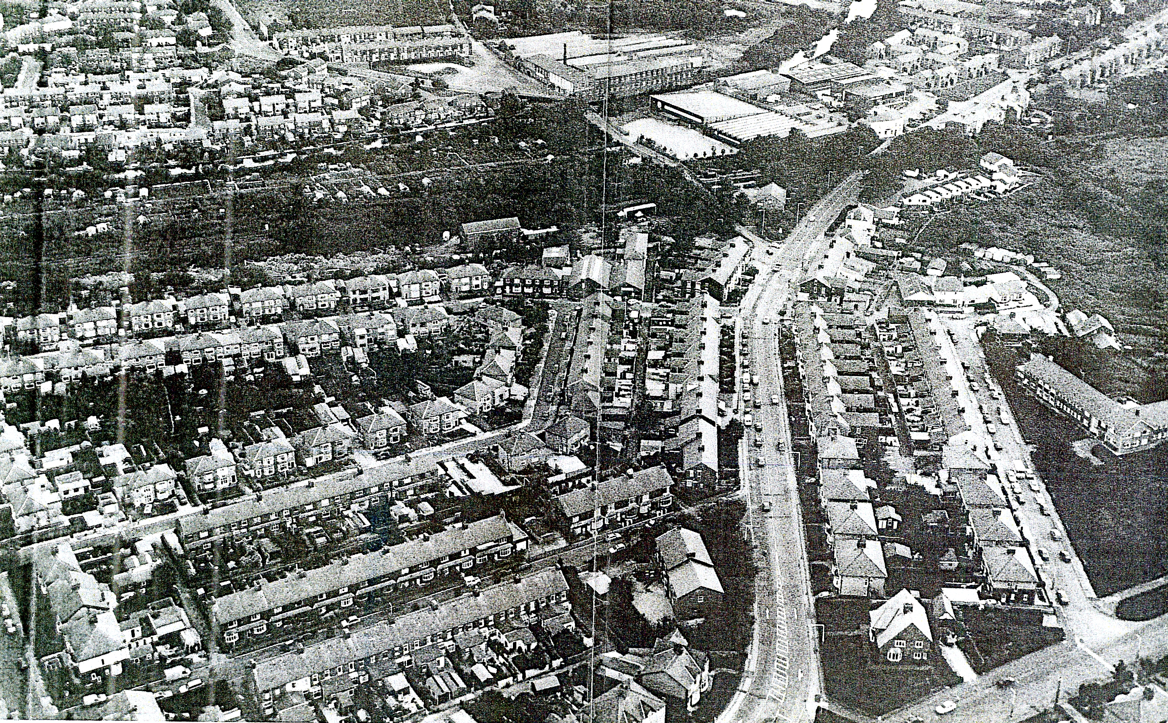
An Aerial
Photograph of the Feniscliffe and Cherry Tree Areas in 1992
The photograph above is dominated by the 1950’s
estate in the foreground with St. Francis Road and Feniscliffe Drive to the
left of Preston Old Road and to the right Hillcrest road off Tower Road and the
now disused Council Care Home. In the upper left corner is the Green Lane
Council Estate with the newer Dalby Crescent estate along the canal side. In
the upper centre can be seen the Cherry Machine Company site and below this the
re-developed Cherry Tree Mill as Q.S. with the two engineering sites behind
alongside Leo’s Carpets with the newly built sheltered accommodation of Hunters
Lodge On the opposite side of Preston Old Road on the site of Cherry Tree House
can be seen the newly built row of modern linked houses.
back to top

