The History of Shire Brow
By
Mike Sumner
Long before Corporation Park was developed the land where it was sited was used for farming. Shire Brow (now Shear Brow) was an ancient track leading up from Northgate the original northern entrance to Blackburn. This followed roughly an ancient Roman route which came out of Salford where it crossed the River Blakewater by ford on its way to the Roman settlement and fort at Ribchester. It passed up Shire Brow and down close to what is now Lammack Road and then Barker Lane on this route. In early days the land to the west of Shire Brow and up to Revidge and over to Dukes Brow was owned by Blackburn St. Mary’s Church later Cathedral and leased out to tenant farmers. This rising landscape was known as Shire Bank and over time small hamlets developed off Shire Brow including Limbrick, Little London, Card Fold, and top of Shire Brow. Starting with Limbrick at the bottom of the brow nearest Northgate followed by Little London which gave its name to the later London Road then Card Fold the word card indicating early textile work with probably wool in stretching the fibres for spinning and lastly the hamlet at the top of the brow. To the west of Shire Brow was Higher Farm and Shire Bank Farm both leased and Shire Bank Fold hamlet. Shire Bank farm is associated with the Pemberton family who first leased the land in 1725 when Thomas Pemberton, who came from a family of tenant farmers from outlying areas, arrived to take up a twenty-one year lease. His lease covered a total of thirty-six acres and his farm house was sited in Shire Bank Fold a cluster of buildings linked to Shire Brow by an ancient track.

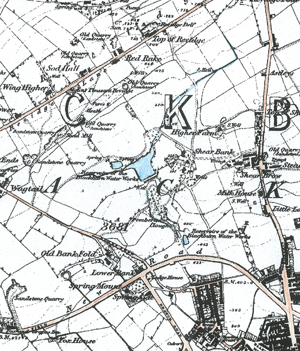
An extract from the 1850 Ordnance Survey Map of the area found north of Blackburn centre and south of Revidge Road
showing the upgraded Shear Brow from the former track, the hamlets mentioned, the newly created Preston New Road and the northern parts of Blackburn
Thomas Pemberton signed a second lease on the 1st. April 1746 for a further twenty-one years for thirty-three acres of land. In 1767 his son John Pemberton signed a third lease for an area of twenty-nine acres for a yearly rent of Ten Pounds and Six Shillings.
A copy of the letter that was with the 1725 lease agreement signed by Thomas Pemberton
A drawing by Charles Haworth showing Shire Bank Fold with the farmhouse in view
and the ancient track leading from it to Shear bank Road
By the time of the third lease the family name had been given to Pemberton Clough a beautiful hillside stretch of meadow, pasture and woodland now mostly situated within Corporation Park. This indicates that the farms main occupation would be pastoral farming given the nature of the landscape with some sheep, young cattle and probably pigs and poultry based near the farmstead. The farm would also grow a little corn and fodder crops for the animals. During the third lease period a part of Pemberton Clough though which Snig Brook passed through was dammed to make a small lake probably for the use of Shire Bank Fold. Until this period Blackburn itself had been copiously supplied with water for its inhabitants from the many springs and wells within its boundary and streams including Snig Brook which ran down to the site of what is now Blackburn College. However by the late 1700’s Blackburn’s population had grown quickly due to the early industrialization of textiles attracting people from the surrounding rural areas to find work in the newly created cotton textile mills. By 1792 Blackburn required a public water supply if only to cope with sporadic outbreaks of fire. At this time the Manor of Blackburn had been purchased by four wealthy individuals (mostly cotton magnets) including Joseph Feilden from the church and who became its Lords of the Manor. Joseph Feilden had also bought the leases of the Shire Bank farms from the church for £290 10s which included the Pemberton land so when the fourth lease was signed in 1788 from the church it later transferred to Joseph Feilden it had an annual rent per acre of £5, £10 or £14 depending on the use made of the land. The lease stated that the messuage and tenement called Shire Brow Tenement consisted of; A house which consisted of two dwellings together with outhouses; Three gardens and half of the common Fold; Several parcels of land called Ridley Croft, Barn Meadow Bottom, rights to the stone pit at Revidge, Little Hey, Great Hey, Farther Marled Earth, Rough Close or Bottom Clough Lane, Clarke Field, Little Limed, Two Crofts, Winter Pasture and Summer Field. This area covered 29 acres and 14 perches of ground.
Later in the 1790,s period the Lords of the Manor impounded the waters of Snig brook at the head of Pemberton Clough and constructed an embankment below the existing small lake and a larger second lake created on the site of an old quarry to form a town reservoir. These are the present Corporation Park lakes which were then called the Big and Little Cans because people took buckets to them to draw water. A few years earlier William Townley obtained the right by a lease to impound the water of the lakes and then laid wooden pipes (which had been hollowed out of tree trunks) placed end to end to various parts of the Blackburn Township below. He placed stand pipes to their ends at the street corners for selling the water to locals, charging a penny per bucket. One of these stand pipes was sited at the corner of nearby Northgate and Duke street where an attendant called Robinson attended at fixed hours to turn on the water with a special key. Another pipe ran from Dukes Brow/Preston New Road down to Winter Street in the Snig Brook area (near Blackburn College). The pipes ran underground and were connected by puddled clay fixed around the connected hollowed trunks.
An early 1900's view of Winter Street where one of the early water pipes ran to a fixed stand pipe
Due to Pemberton Shire Bank Farm being on an elevated position overlooking what was then becoming a more industrialized Blackburn it was described as the most beautiful place in Blackburn in the late 1700's. However by the early 1800's, as the industrialization of Blackburn grew considerably with the ever expanding Textile Industry the Pemberton family turned to the in vogue cotton manufacturing when James Pemberton established Roe Lee Mills near Blackburn cemetery and also built nearby terraced houses including those along Pemberton Street for its operatives. Shire Bank Farm tenancy was taken over when John Pemberton left the farm and was taken over by Edward Coar who was then succeeded by his brother James Coar until later when it and its lands along with those of George Radcliffe were sold to the town and one of its Lords Joseph Feilden. Mr. George Radcliffe built Shire Bank House in about 1830 which was sited close to Shire Bank Farm. He was a surveyor by profession and an agent dealing with the estates of the Feildens of Witton Park and Feniscowles areas and also for the Cardwell family. Just like the Pemberton family he farmed a large estate in the area abutting their land and on the Revidge hill side. As his lands dovetailed with the Pemberton's and in places mixed up each had to cross the others land at various points to get from one part of their farm to the other. This proved inconvenient and as both had the same landlord they mutually agreed an exchange of land at certain places to make each farm more compact. His farm extended from his house over half the land now covered by the lakes across to the bottom of Dukes Brow and up the Clough of Revidge on the other side. The two tenements were approached by a winding cart track (see map) which has since been straightened improved and widened running into Shear Brow and is now Shear Bank Road and the fields on either side of this road were part of the two farms lands and are now covered by various Victorian and Edwardian houses both terraced and large detached properties. Large Trees still present in the area are the remains of those that once stood in Pemberton Clough. Other old trees including sycamore, oak, and alder are still to be seen in Corporation Park and Lilford Road.

A 1955 view of the former Pemberton Street cottages built by
James Pemberton for his cotton mill operatives
James Pemberton who founded Roe Lee Cotton Mills and was married to Mary Haydock
A modern relative namely Maurice Pemberton with his wife Joan pictured
by a tree that was on the site of the former Shire Bank Family farm pictured in 1995
Eventually Joseph and John Feilden sold all the land formerly used by the two farms by a deed of conveyance to Blackburn Borough Corporation on the 26th October 1855 for the sum of £3,257 covering an area of 50 acres and 18 perches. The newly formed Borough Corporation decided to turn the land into a park to meet the leisure needs for its rapidly expanding population and named it after itself. However when it was sold by Joseph Feilden for the park it was specified that the council would undertake to make roads on either side of the park within one year of the sale to allow easy access into it and these became East and West Park Roads. It was also agreed with Joseph and John Feilden that they would lay out, plant and maintain the land designated for a public park and ensure there were walks and pleasure grounds to allow the public to exercise and have recreation on the land and not use it for any other purpose. They were also prohibited to erect any buildings other than lodges, conservatories, refreshment room or ornamental buildings and no liquors could be sold there plus:-
1. To build, keep and repair a fence or wall around the park not exceeding five feet.
2. To make five entrances for carriages and foot access.
3. Plans for buildings that were to be built to be submitted for approval to the Feildens.
A plan showing Shire Bank Farm and the proposed route for the building
of East Park Road in the 1850’s showing the ponds and some of the fields
The above map shows A 1854 plan for a proposed public park on the lands sold by Feilden and the proposed carriage roads that would eventually become East and West Park Roads. It also shows the new turnpike road (Preston New Road) and existing settlements.
The park now called Corporation Park the first park to be created in Blackburn was opened officially with much fanfare on Thursday the 22nd. October 1857 by the mayor of Blackburn Mr. William Pilkington a cotton manufacturing magnate of the day and Mr. Joseph Livesey the proprietor of the Preston Guardian and the great pioneer of teatotalism. Mr. Pilkington provided three of the water fountains in the park for its opening day and a slate one was later provided by Mr. John Dean.
Above is a Lithograph picture of corporation Park looking down from Revidge printed by Maclure, MacDonald and McGregor of London, Liverpool and Manchester which also shows two Russian cannons from the Crimean War donated by Queen Victoria since replaced by later cannons. It also shows the many factory chimneys of the textile mills and the houses of their operatives. Other buildings in the view include the newly built Town Hall and Market Hall, the Parish Church, St. John’s Church and St. Pauls Church in the valley.
During a major down time of the cotton industry called the Cotton Famine when supplies of raw cotton couldn’t be obtained to supply the textile mills causing great unemployment and distress for its workers the Council initiated Public works Projects. One of the large projects was the construction of Revidge Road to connect two existing ends at Billinge and Four Lane Ends through the rocky crest of the ridge. This would also allow access in the northern part of Corporation Park where sporting activities of Tennis and Crown Green Bowls were established.
A lithograph published in the London weekly News showing the unemployed cotton operatives
given work to create Revidge Road and the northern steep slopes of Corporation Park
An 1890’s view of Red Rake on Revidge Road across from the northern entrance into Corporation Park
showing the ancient cottages which by now had opened up as a café and shop to serve the needs of locals and visitors to the park via the Revidge Road entrances

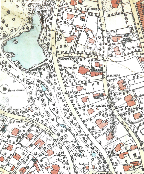
An 1893 Ordnance Survey extract showing Preston New Road, East Park Road and
Shear Bank Road and the many new large detached houses alongside Corporation Park
which proved very popular sites for the increasingly wealthy industrialists of the town and the
middle classes to escape the towns central industrial landscape and pollution.

