Historical Development of Whitebirk and Intack Areas
By
Mike Sumner
SITUATION
Whitebirk and Intack areas form a suburb to the east of Blackburn centre. Part of the area now falls within the Borough of Blackburn with Darwen whilst the eastern section falls within the Borough of Hyndburn. To the north-east of the area is the town of Rishton with the Greenbank and Little Harwood areas of Blackburn to the west, Sunny Bower area to the north and Accrington Road to the east. The main line railway from Accrington to Blackburn runs along the northern border from west to east and the Leeds Liverpool Canal crosses the area from south-west to the north. On the eastern edge of the area is the M65 Motorway which has four slip roads leading on and off it via Whitebirk roundabout.
EARLY HISTORY
The word Whitebirk has Saxon roots derived from Hwite-Byre meaning white or silver Birch trees. Originally, the area was forested, being part of the woodland that stretched from the Ramsgreave, Mellor ridge slopes to Little Harwood, and, in the early days, was used by Lords and Royals for hunting wild boar, deer and other animals and birds. The wood was also used to construct early housing and provide charcoal for smelting metals. The Anglo-Saxons were in the north-west of England from the sixth century to the Norman invasion in the 11th century and the Medieval Ages. Nearby Rishton’s name was derived from the word Rise, Rush and Tun meaning a place of rushes, which was accurate as its area was partly recovered bogland from Rishton Moor. Intack originally named Intake was first mentioned in the late 1700’s, early 1800’s and could possibly relate to an area of farmland that had been enclosed after being former common land. At the same time, Tooka from the word Takka relates to ewe in the 16th century and Takely relates to a pasture of Tegs (sheep). It is likely that the two areas of land would have been owned by either the Lords of Blackburn or Rishton, and later, by Norman knights, after their successful invasion in 1066. Lancashire, however, was amongst the last English territories to feel the effect of the Normans and Lord Gilbert de Lacy was first to seize land in East Lancashire. Another knight who took lands in the area was Lord Roger de Poictou and both knights were under the service of William the Conqueror. The local lands used by farmers would have been rented out from the lords who would provide them with protection. The Doomsday Book stated that Edward the Confessor held 'Blagborne' which had a wood one mile long and wide which was home for hawks. He also held Huncoat with a wood six miles long and four miles wide, and therefore, held the Whitebirk and Intack areas. In the 12th and 13th centuries Rishton, Whitebirk and Intack areas were controlled by the De Rishtons, Gilbert de Lacy, John de Ratcliffe, Adam de Billington with the De Lacy’s dominating the main central areas of Blackburn. Edward IV gave Blackburn lands to the Talbots of Bashall. In Tudor times a variety of Lords controlled Rishton areas including Nicholas Ryshton, Nicholas Feilden, George Livesey, George Abbot, Xpofer Whalley and William Hogeson.
The most important early road or track through the area went from Preston to Blackburn via Preston Old Road then, via Whitebirk, on to Rishton and then Burnley, providing vital access to Whitebirk and Intack areas. From 1618, the enclosure of common and waste land occurred which would have affected owners of farmland often cleared from woodland in the Middle Ages. Owners of land at Whitebirk in the 1600’s included George Abbott in 1622, who was from a family of ancient freeholders and lesser gentry and John Abbott from the same family in 1636 who was also elected as a Governor of Queen Elizabeth’s Grammar School in 1646. There was also a James Abbott of Higher Whytebirk Farm who died in 1659. At this time, Lord Fauconberg was the Lord of Blackburn Manor and held lands at Whytebirk. During the 17th century the Civil War occurred. The Earl of Derby held the Blackburn area for the Royalists but was then overthrown by Oliver Cromwell before the Monarchy and Charles II regained it in the 1660’s. By now, lands in Rishton and probably Whitebirk were owned by Thomas Whalley, Thomas Talbot, Christopher Hindle, William Bell, Christopher Duckworth, Robert Dewhurst and John Baron.
During the 17th century local rural economies included handloom weavers as part of the Domestic Textile Industry based around Blackburn living in small communities and hamlets up to six miles from Blackburn, including the Whitebirk and Intack areas. Each weaver working from their cottage signed up with a Blackburn cotton merchant e.g. Robert Hopwood or George Briggs who had up to 8oo handloom weavers on their books as part of a “Putters Out“ system. This involved them with supplying the weavers with spun cotton, if they didn't spin their own, in which case they would supply raw cotton and then collect the woven pieces from them at set prices depending on their size. The weavers produced cloths that could be used for jaconets, checks and shirting material. Up to 1800, it was estimated there were 20,000 handloom weavers within three miles of Blackburn centre with completed cloth pieces mostly sent to London, or, printed locally. Also, it is known that early bleaching of cloth was carried out at the same time in the Whitebirk area, where cloth was spread out in fields for the sun to bleach it. Richard Bently was working bleaching grounds in Whitebirk in 1793. By 1779 handloom weaving shops were created, handlooms would be collected together in farm buildings such as barns creating an earlier form of the Factory Textile System. It is also noted that there was an old stone detached cottage built at Whitebirk which had a hoist beam and a “Taking In" door on the gable end for taking in cotton probably. The cottage had a date stone for 1770 indicating it was built by Edward and Elizabeth Brewer whose family had interests in the early textile industry of Oswaldtwistle. By the 1770's pieces of cloth created for India were called Calicos.
Yates map of 1786 shows a Turnpike Road following an earlier route already described above, which ran from Preston to Blackburn and on through Whitebirk to Burnley. These had Toll Houses along the routes, a fee paid for using them which provided funds for maintenance of the road; they were operated by Trusts. This road can be seen below on the 1786 map running from Houghton in the west passing through Blackburn and on to Bottom gate, Hole House, Whitebirk and on to Rishton.
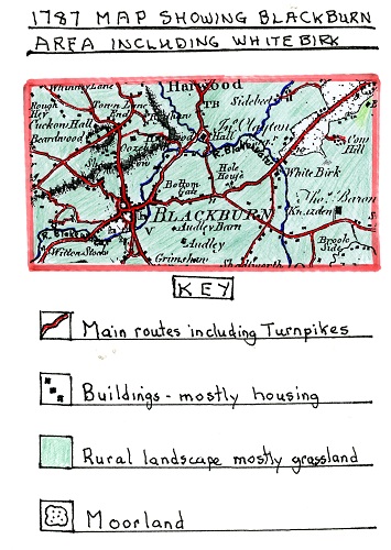
A 1787 Map showing the Blackburn Area including Whitebirk.
The 1787 map shows the turnpike road mentioned above running from Witton Stocks through Blackburn, Bottom Gate, Hole House and White Birk. At White Birk one of the larger black squares denoting a building on the junction of two roads would be one of the oldest inns in the Blackburn area first built in 1735, namely, the “Red Lion”. It is unique for an inn in Blackburn as it was classified as an Ancient Monument which meant it couldn’t be altered greatly. It has well preserved features including mullioned windows and a steeply pitched roof typical of the 1700’s with stone slates. All its original beams and woodwork had no nails in them but were held together by hand-made pegs and dowels.
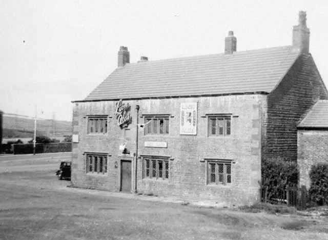
A picture of the Red Lion Inn in 1953 owned by Lion Brewery but first built in 1735The inn was ideally situated to serve both the locals of Whitebirk and Intack and travellers passing along the ancient toll road shown earlier on the 1786 map. During the 1700's much of the rural land in the Whitebirk and Intack areas had been cleared of woodland but was often barren including the nearby Rishton bog land and the soil was of a poor quality. The soil needed to be upgraded, and, as farm machinery developed during the Agricultural Revolution, farmers could do more on the land. Farms were mostly pastoral with sheep and cattle raised, oats was the main crop grown both for a fodder crop and used by locals to produce porridge a staple diet during this period for poorer people.
At the start of the 1800's, the golden age of “hand looms" had passed because of the early development of the Factory System, first with banks of hand looms in workshops, then later, with steam power looms in the new factories that were built which badly affected the independent hand loom weavers' business and brought down the price of cloth. As a result, many of the hand loom weavers migrated from rural areas such as Whitebirk and Intack to obtain work in the newly established cotton mills. The number of mills grew enormously in the Blackburn, Accrington and Rishton areas and this was referred to as “Rural to Urban Migration". The remaining hand loom weavers were forced to produce fancy goods the power looms could not. The life of the hand loom weavers was hard, reliant on putters out who hadn't moved into operating the new cotton mills. Their staple diet was oatmeal porridge with churned or sweet milk, potatoes made into stews with onions added but rarely with meat. Many of these remaining hand loom weavers became destitute with large families having to cope in small cottages as they sought new work on nearby farms, but, by now, farm machinery meant fewer workers were needed other than at harvest time. In earlier periods there was a chance of work when early textile developers did not want to finance a new mill so developed sheds for 30-40 hand looms including some farmers using their barns or outbuildings.
By 1818, the Leeds Liverpool canal was completed and passed through Whitebirk on its way to Blackburn centre coming from the Burnley and Rishton areas. The canal offered cheap reliable transport especially for heavy goods and attracted early industry especially textiles to its banks for easy access to barge traffic and a water supply for steam power. By the 1820’s there was a regular passenger service from Blackburn to Burnley through Whitebirk. The passenger barges had roofs and side windows with extra passengers sitting on the roof.
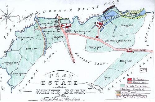
A Map/Plan of The Whitebirk Estate in 1835 With Key
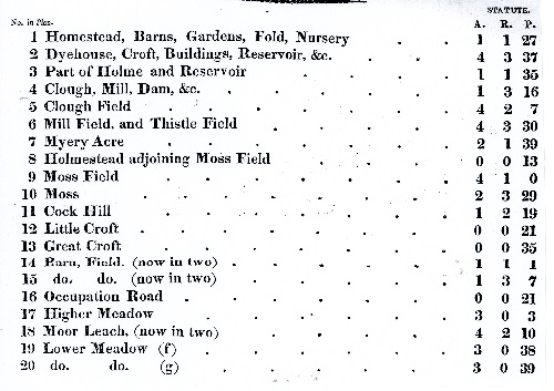
The above map/plan shows Whitebirk as a scattered hamlet in 1835 which, at its centre, had the Red Lion Inn to the left of No. 1, where Burnley Road, coming from Blackburn, continues into what is now Blackburn Road running to Rishton. At this time, Shadsworth Lane would have run through Intack (off the plan) on to Shadsworth but is later called Whitebirk Road. The newly built Leeds Liverpool Canal in the estate is shown with its tow path on which the horses pulled the barges. Using the key (No 16), Occupation Road just crosses the canal and ends but does not continue to Brownhill and follows the line of the later larger Whitebirk Drive. As can be seen, lands to the south and west belong to the Rectory (Church land from St. Mary’s Church, later Blackburn Cathedral in Blackburn centre). To the north and east is part of the Petre family estate who controlled much of the Rishton area and farmers of these areas would lease land from them. As to the settlement at (No1) Whitebirk hamlet there is a cluster of homestead buildings including barns which could indicate a farm indicated by (No5) but clearly a diversified one as it has gardens and a large nursery to supply plants or shrubs to locals or nearby Blackburn areas. The building at No 2 was one of Blackburn’s oldest industrial sites developed from the original outdoor bleaching activity into industrial buildings for chemical bleaching and dyeing developed probably by Richard Bentley, but, owned at this time, by Robert Peel of Accrington, who leased out the premises. Part of the property used for dyeing was leased by T. H. Maude a calico manufacturer and dyer during the 1830’s. Machinery used in the buildings included a steam engine and water wheel, using water taken from the nearby Knuzden Brook via a goit and from Rishton reservoir to feed the works own reservoir. In 1835, Haworth and Barnes chemical manufacturers of Church leased the buildings, and, by 1839, James Barnes a calico bleacher of Accrington had taken over and the Barnes family continued a long association with these works. The original buildings were made of stone and mostly single storey with roof ventilation. At the entrance to the track leading to the works was a detached stone cottage built in 1770 and mentioned earlier in the 1700’s era. It is probable that the house was used as a receiving warehouse for yarn. The building adjoining Moss Field (No 9) numbered No 8 on the plan was called White Barn Doors shown on later maps and consisted of a series of cottages built by the side of Shadsworth Lane and involved in farming the nearby land and could possibly have been farm cottages from the two Whitebirk Farms off Blackburn Road leading to Rishton.
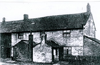
Early photo of White Barn Doors Cottages
The picture shows that the properties were brick built with clearly defined outhouses and were two-storey. Above Clough Field (No 5 on the plan) is part of the remnants of the original woodland that covered the area. As can be seen the fields on the plan are all now enclosed and owned with names attached which indicate that those in the east/south-east/south-west were of poorer quality including mention of moss, thistle and clough (cleared woodland). Those in the centre of the area are clearly older and smaller and of better quality as they have most likely been improved including Little and Great Croft (Nos 12 & 13) and Barn Fields (14 & 15). Samuel Heywood, writing in 1818, outlines the miserable situation of the rural districts in Blagbornshire having a thinly scattered population who were uncivilized and ungovernable as a result the bishop abstained from having jurisdiction over it!
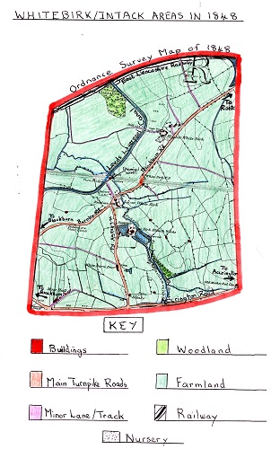
The 1848 Ordnance Survey Map of Whitebirk and Intack Areas
This map clearly shows a more complete and larger area of Whitebirk and Intack than the 1835 plan but with a smaller scale. The settlement is still scattered but sited mainly alongside main routes, namely Burnley Road to Blackburn, Blackburn Road to Rishton and Whitebirk Road (Shadsworth lane) to Intack and the main Accrington Road. At the centre, Homestead Farm now has more nurseries and cottages can be seen alongside Blackburn Road, with farm buildings, also at Higher Whitebirk Farm along with numerous outbuildings and cottages. The field pattern displayed indicates the better, flatter land near the centre of the area, the east and south had smaller and more numerous fields, those to the north and west are larger, where land was of lower quality, with slopes mostly used for grazing sheep with the smaller fields used for raising cattle and fodder crops. Intake (later Intack) is shown as a very isolated area south of White Barn Doors with two properties and a ruin with the area used for farming. On the Leeds Liverpool Canal can be located a wooden turn-bridge just north of Whitebirk centre allowing the minor track (later Whitebirk Drive) to cross the canal to get to land on the other side. As houses at this time often didn't have a direct water supply there were numerous local streams other than Knuzden Brook from which to obtain water supplies. By this date some steam powered machinery for farmland would have been used although horse drawn equipment would still dominate as it did for road transport. At this time, Charles Tiplady, writing in 1849, describes a walk along the banks of the River Blakewater that Knuzden Brook joined to the west of the Whitebirk area having in the past clear water you could drink from but now was heavily polluted due to industry developing alongside it e.g. Whitebirk Bleachworks. By 1848, Whitebirk Bleachworks was operated by Barnes Brothers & Co. and the business had expanded with more buildings and another large reservoir to store water to run its steam engines. This was due to the rise of the Textile Industry, with cotton mills springing up outside the area in nearby towns. Another business started in this period was Whitebirk Chemical Works which was opened in 1846 by James Pollard of Oswaldtwistle, however, by 1848, his partner, John Grimshaw became the sole owner. A bobbin turning shop and sawmill was later added to the site by the side of the Leeds Liverpool canal on former farmland and marked on the 1848 O.S. Map. The works produced dyes and oils in the early days but only from small premises. In 1851, the Borough of Blackburn was first established which led to it creating Borough boundaries with one passing through Whitebirk dividing it off from Hyndburn. Another major change in the Whitebirk came with the creation of the East Lancashire Railway which ran across the extreme north of the area. At its inception in 1845 it was called the Manchester, Bury and Rossendale Railway Company, however, it then amalgamated with the Blackburn and Preston Railway Company and became known as the East Lancashire Railway. This provided a new mode of transport for the area as it ran from Blackburn to Rishton and on to Burnley. In time, the railway took over much of the canal's transport trade as it was a faster than the barge. Moss Hall, in the extreme southern corner of the map, was close to Accrington Road. On the outer edge of the Intack area was an old farmstead which had mullioned windows indicating its age which dated to the 17th century. It was originally the home of the Whalley family of Sparth and Whalley and records show there was a William Whalley living there in 1692, and probably, his son James in 1713 and grandson Thomas in 1725. In 1744, a John Whalley lived at Moss Hall and was still there in 1768. Moss Hall then came into the possession of the Kenyon and the Nutter families. The end terraced houses at the Fountain Inn cross-roads on Accrington Road are called “Moss Hall Terrace" and were built in 1884. The last family to live at the Hall were the Wood family before it was demolished in 1930.
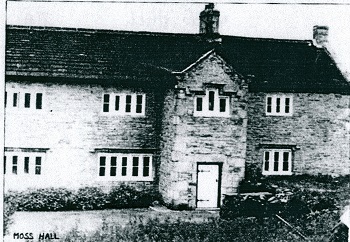
A picture of Moss Hall as a detached farmhouse with mullioned windows
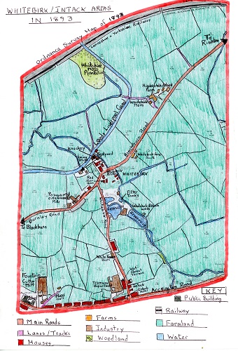
The 1893 OS Map of the Whitebirk and Intack Areas
The first thing that the map shows despite a lapse of 45 years, is that the area has not changed greatly and is still dominated by farmland. The map indicates that the field patterns have little changed but there has been an additional farm created, namely Whitebirk Farm South. By now, although farm machinery had become more mechanised, first by steam power, and, more recently, by fuel, horses would still be used on a large scale. The main building at Higher Whitebirk farm had grown larger, and, by now, the word Whitebirk is shown as one word rather than two. Housing in the area is still small and scattered apart from a large growth of Victorian terraced houses along Accrington Road as settlement in the Intack area increased, along with a name change from Intake. An interesting additional row of Victorian terraced had also been built alongside Whitebirk Road called Wet Jacket Terrace and the Intack Hotel had been built at the junction of Whitebirk Road and Accrington Road. At the same time, the map show Intack's first Primary School on Accrington Road.
By 1893, the largest change to the areas was the increase in industry. Whitebirk Bleachworks is shown having a larger building for bleaching and dyeing cloth and was still run by the Barnes Brothers. Whitebirk Chemical Works, sited by the canal, and formerly operated by John Grimshaw & Co. in 1874 to make dyes for the Textile Industry had not lasted long before Grimshaw and Parkinson took over forming a “ Turkey Red” Dyeworks. In time, that too failed, and the premises were bought by Joseph Davies, a horse slaughter. In 1881, he had a bone works in fields to the north of the area, where later, the electricity works were built. This is the site shown on the map as a 'Knackery'. The land owned by Davies where the Bone Works had been sited was now farmed by the family with horses, sheep and cattle. The family were one of the largest horse dealers in the whole area with local breweries and the Borough Corporation all buying from them while others were exported abroad. The Davies family didn’t just slaughter horses but cattle and other animals; a lot of the meat was sent to London. They also bought carcasses for the business from a radius of 50 miles. Certain parts of the carcasses were made into fertilizers with the fat sold to be made into soap and the hides sent to tanneries to be made into leather. The company used to move dead horses or other animals on a skeleton cart with the animal laid on its back, the head hanging over the front and the rear hanging over the back but later these were made redundant and they had to use closed trucks.
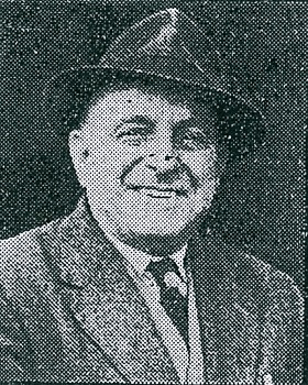
Mr. Joseph Davies, the founder of the company
The 1893 map also shows the Perseverance Oil and Grease Mill sited alongside Burnley Road. Originally, in the 1850's, it was a small naphtha and chemical works which was taken over, in 1868, by john Eccles, an oil refiner, who first started in business in 1808 before moving to Whitebirk. By now, the works refined lubricating oils and grease mainly for industrial use. The first mineral oil ever imported into the country was for the Eccles Whitebirk company. The site was altered between 1882-4 when Mr. Eccles also built a school for his workers children. His Oil Works were two storey and at the rear had a plaque on the wall advertising the company.
In 1872, the Darwen Mining Co. Ltd. sank a coal shaft into coal seams via the lower Mountain Mine (Whitebirk Colliery). It had two double steam winding engines to operate two cages going down the 408ft shaft and had 40 coke ovens built near the pit head, and had approximately 120 employees. The boundaries of the mine ran through nearby Furthergate, Shadsworth, Knuzden and Whitebirk itself. There were also coal pits on the area now covered by Philips Road which were 240ft deep called Armistead Colliery, and, where Whitebirk industrial estate is now sited was the Cross Head Pit which ceased work in 1888. The original company operating the Whitebirk Colliery failed and the pit was operated by the main creditors, namely, Darwen Co-operative Society and was now called Whitebirk Colliery Co. It was sold again, in 1890, to W. H. Shaw & Co. of Belthorn and Haslingden. The pit workings extended into a top coal seam of fire clay and coal which led to a glazed brickworks being added to the site to meet the need for bricks with terraced housing being built around the new textile mills. By 1896, the mine was completely abandoned but W.H. Shaw & Co continued the brick works and built an aerial wire flight from Belthorn to Knuzden in 1903 with 60 trucks to carry coal and clay before steam locomotives took the cargo the rest of the way to Whitebirk brick works. Whitebirk coal mine itself was sited to the side of Whitebirk Road with a two-storey office and stable by the road.
The mine site had a glazed brick chimney erected at the pithead which remained there till the 1930’s. Whitebirk colliery was one of the last operating on the Blackburn Coalfield where mining of various sorts could be traced back to 1569 when Bell Pits were first used to reach the higher coal seams.
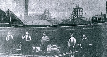
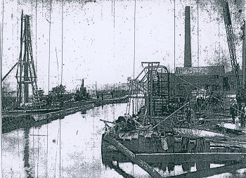
A picture taken from the nearby Leeds Liverpool Canal bank showing Whitebirk Colliery
in the background, in 1896, and Whitebirk Boat Yard in the foreground
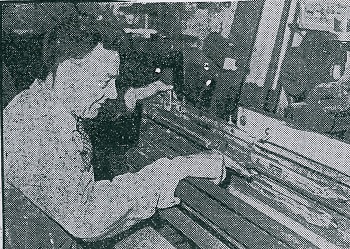
In 1870, T & J Hodson established a boatyard on the banks of the Leeds Liverpool canal (see 1893 map) bringing boat building skills to the yard learned earlier in the Tarleton area. He bought the premises from John Grimshaw of Whitebirk Chemicals as it had a bobbing turning shop and sawmill on a 21- year lease from the Canal Co. James Hodson was joined later by his three sons. During the early days, they could build a barge for £180 when labour costs were much lower e.g. in 1878 it was 5 shillings and two pence per day. Originally, all the skills used to build a boat were done by hand including using large saws to cut the oak timber and seam caulking, which was packing the gaps between the boats flat bottom planks to ensure they were water-tight before tar was added and then the barges were launched down slips into the canal. By the end of the 19th century, the yard had three slipways, two for raising boats out of the water for repairs and one to launch boats back into the canal. By now, they had 12 workers to operate the yard. Their main customers were the Leeds Liverpool Canal Co., Rishton Colliery and Shackleton’s and Appleby’s grain carrying companies who obtained their grain from Birkenhead Docks.
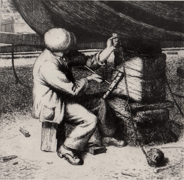
A sketch of a boatbuilder caulking a barge’s wooden planks
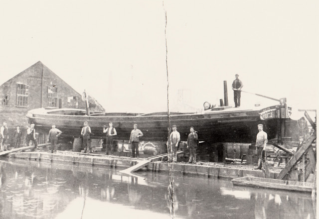
A photograph of a completed barge called Alice about to be launched with James Hodson stood on the right of the picture.
This was the last boat to be launched on the third slipway.
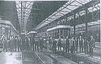
Also visible on the 1893 map is a Tramway Depot built alongside Whitebirk Road at Intack. It is close to Accrington Road on land that had previously been farmland which was owned by Blackburn Tramways Co Ltd. By 1898, Blackburn Corporation decided to take the enterprise over in the interests of the Borough's public, and, by 1899, had taken over Blackburn and Over Darwen's Tramway track within the Borough which covered two and half miles. The total cost of both operations was £109,000. Once purchased they began to equip each section of the existing tramway with electricity at a cost of £150,000. The systems route now extended to 14½ miles. At the same time, 48 double-decker open topped trams and 12 single deck trams were purchased, but, it was not until 1907, that all the trams were housed at the Intack Depot. Previously some trams were housed at the Simmons Street, Jubilee Street and Intack Depots. Earlier trams had first been pulled by horses and then by steam engines. The new electric system required overhead electric wires built along the routes supported by posts with arms stretching out to hold the wires. Electric tram services first started in 1899 on Preston New Road and Witton Stocks, followed in 1900, by the Bolton Road to Darwen Borough Boundary. Initially, for the first six years until 1905, the system ran at a loss, but thereafter, it proved to be a financial success for the Corporation. The 48 open topped double decker trams also had an open platform therefore drivers and conductors were subjected to all weathers.
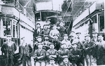
Intack Tram Depot mechanics shown in oil-stained working clothes and obligatory hats
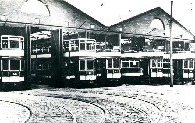
A picture showing both open and closed topped double deck trams at the Depot
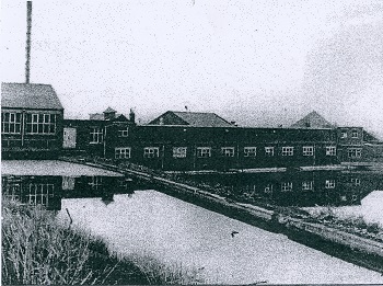
On the edge of Whitebirk and Intack was the Greenbank area of Blackburn where, in 1863, Henry Livesey established a foundry producing general mill furnishings and winding machines for the growing cotton industry. Henry Livesey learnt his trade in textile mills with Joseph Harrison & Sons and he developed ideas for new machinery. The foundry soon became known as the Greenbank Foundry and Iron Works; bobbin and shuttle making was added to its operations in 1871. By 1876, it was producing warping and sizing machines, and, in 1879, a new moulding and finishing shop was added. Further extensions to the by now large works were made in 1905 to manufacture Northrop Looms. Henry Livesey textile looms and other machinery were exported to many countries around the world.
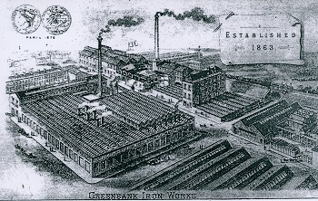 Henry Livesey, Greenbank Iron Works in 1863
Henry Livesey’s sons Robert, William and Frank took over the company which was headed by Robert. The site now had huge timber stores including ash and sycamore for the manufacture of bobbins, birch used for making spools and yellow pine, cherrywood and mahogany used for parts of the machinery. Large amounts of bar iron and steel were used to make the looms and other machinery much of which the company designed themselves. At its height, the company could equip a weaving shed of 600 looms within four weeks and employed 800 workers. The quality of the machinery produced was of the highest standard which the firm prided itself on and led to a large demand for its products both at home and abroad.
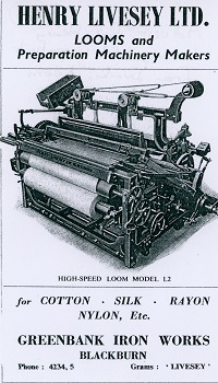
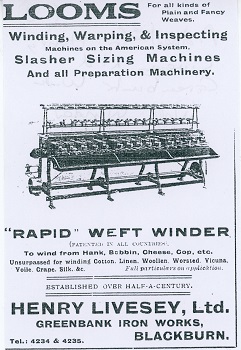
Adverts for Henry Livesey Limited Looms and Weft Winder in the 1920’s
Another Greenbank development during this period was the new Gas Works which opened in 1900 when the company took over Blackburn Gas Light Company that had originally been based in Gorse Street. It was developed due to the great increased demand for gas at this time and the new site provided ample room for an extensive gas making plant to be built. It was also near the railway that ran alongside; therefore, it was easy to transport the coal needed to produce gas and it was also not far from the canal which was the cheapest transport form to bring heavy goods in by barge from the Burnley coalfield. The Greenbank site was eventually taken over by the North- West Gas Board.
New Gas Works built at the Greenbank site A view inside the Retort Room showing the workers at the Greenbank site
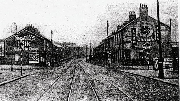
This early 1900’s view of Whitebirk Drive’s junction with Accrington Road shows the Intack Hotel
on the right owned by Lion Brewery and tram lines leading into Blackburn centre from Accrington lined by terraced houses
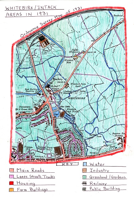
The 1931 Ordnance Survey Map of the Whitebirk and Intack Areas
The first major change that is visible on the map over the period of 38 years since 1893 is the loss of farmland. The south and south-eastern areas of Intack were especially affected due to new housing areas. In the north, the building of the new Electric Power Station and its mineral tracks, together with the construction of the new Whitebirk Drive took place. Industrial coverage in the area remains almost the same as in 1893 except for the new Fountain Free Brewery on Accrington Road in the extreme south-east.One of the major changes was the construction of Whitebirk Drive across existing farmland to link with the existing Whitebirk Road. This new road was part of the new Arterial Road system designed to take the increased motorised traffic round Blackburn centre rather than through it. Work on this new road system started in 1921 with the aim of relieving the high unemployment in Blackburn following WW1. All the work, including building bridges, was completed by unemployed men of Blackburn Borough and Rishton. This new ring road round the northern part of Blackburn started at Preston New Road and led to Brownhill. Here, it crossed the Blackburn to Whalley Road and continued to Sunny Bower. Finally, at Whitebirk, it met the road from Blackburn to Burnley. Originally, the new road was bordered by fences and measured 120 feet wide between the fences. For most of its journey it was a single carriageway apart for a section from Whalley New Road at Whitebirk to Roe Lee just before Brownhill when it was a dual carriageway. Later, the whole route was made into a dual carriageway. The total length of this new road was 4 1/2 miles. After it was completed Whitebirk Road leading to Accrington Road was also widened. In total, it became the largest road making scheme of the century and the section in Blackburn Borough cost £155,150 with half the costs paid for by the Department of Transport, it was finally completed in 1928.
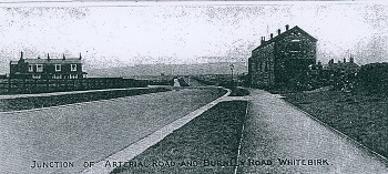
A view of the junction of Whitebirk Drive (Arterial Road) and Burnley Road at Whitebirk
The position of a new bridge built over the Leeds Liverpool Canal taking the new road over it at Whitebirk.
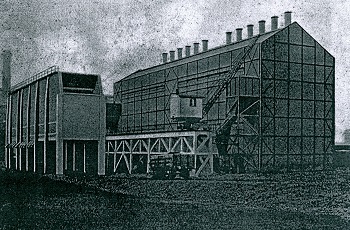
Another major development in the Whitebirk area was the construction of Blackburn’s new Electric Power Station which was opened on 21st October 1921 by Lord Derby. It was the first power station built under the supervision of the Electric Commissioners and owned by Blackburn Corporation. The building scheme, costing £1.25 million, started 20 years earlier but building difficulties due to the First World War delayed the work with the land purchase in 1914. Once completed, it could supply not only Blackburn’s electrical needs but also neighbouring towns and districts. The station was built on open moss land in the north of Whitebirk close to the main railway on a 14,700 square yard site. The two turbines were powered by coal and water and had seven 50,000 steam generating units and four wooden cooling towers. The site had a 20-ton crane for unloading coal barges on the nearby Leeds Liverpool Canal from specially built wharfs and a track (see map) on which to transport coal up to the station and another mineral railway track direct to the station (see map). Previously, electricity had been produced at the Jubilee Street site off the Boulevard area. Water to create the steam power was obtained from wells bored at the site and much of the coal it used came from the nearby Hapton Colliery . Ash from the burnt coal was removed by an electric battery- operated locomotive to a conveyor belt that took it to be distributed on the surrounding land where there was enough room to dump it for many years. The station was built to form part of the National Scheme and the electricity Act of 1919. The building work contract was undertaken by the English Electric Company. Once a new electric sub-station was built in 1933 and transmission lines fitted the electric current could be taken to that of other stations and become part of a new National Electric Grid System and the central Electric Board took control of Whitebirk Power Station.
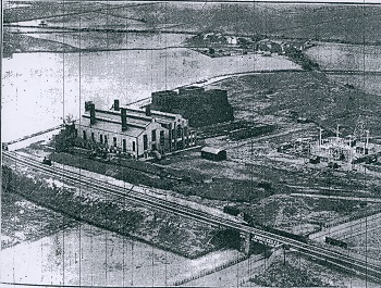
An aerial view of the new Whitebirk Electric Power Station site and its four wooden cooling towers when it was run by the Central Electric Board with a partly constructed sub-station on the right.
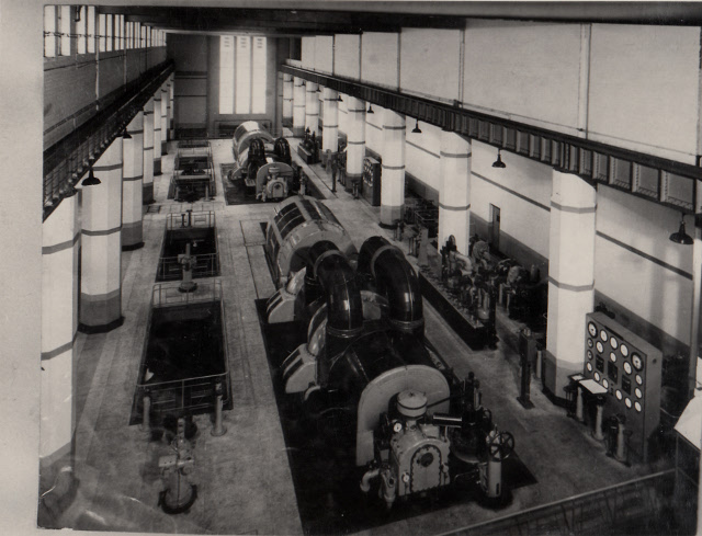
An internal view of the Whitebirk Power Station’s Turbine House
Coal barges bringing coal from nearby Hapton Colliery
to Whitebirk Power Station and Greenbank gas works. Canal transport of heavy products
such as coal was very economical e.g. one barge with two trailers could bring 140 tons of coal from Burnley to Whitebirk.
Of the existing industrial sites T.& J. Hodson boat building yard continued to build a few canal barges but now relied more on boat repairs. The Davies Slaughter-House continued and further refined the business as fewer horses were now used. By 1931, Whitebirk Bleach works had expanded their premises to meet the needs of local textile businesses including now bleaching gauze surgical cloth and piece textile goods.
A picture showing the increased premises at Whitebirk bleach works and their reservoirs.
The Perseverance Oil and Grease Mills were now known as Eccles (Oils) Ltd. With the works having been completely re-built since W.W.1. Their products were now sent all over the world and the company was now run by John James Eccles. Adjoining the works was Mostyn house where the Eccles family lived. Intack Tram depot continued as some trams were still in daily use but now all double deck trams were enclosed. By 1929, however, Blackburn Corporation had purchased 12 omnibuses powered by diesel fuel and operated them on the Little Harwood, Wensley Fold, Whitebirk, London Road and Arterial Road routes. In 1930, buses were also used on the Darwen route in conjunction with Darwen Corporation. In 1931, buses took over East and West Park routes, Pleckgate, Guide, Lower Darwen, Mill Hill and Mosley Street routes, and, by now, required 27 more buses and all the buses were now operated from a new omnibus garage at the Intack site. In 1926, Intack depot opened an employees' bowling green adjoining the depot site where previously the land was used for tipping. The opening game was played by Blackburn Councillors. By 1931, the Tramway company had merged into Blackburn Bus company which itself was then taken over by Blackburn Corporation.
A view of the employed mechanics at Intack Tram Depot.
The W. H. Shaw glazed brick works at Whitebirk on the site where the original coal pit was sited continued to 1908 before the business was transferred to Waterside. Later, the site would be developed into allotments. The Greenbank Gas Works had expanded by 1931 to meet the increased demand for gas by both industry and the local population which had grown considerably resulting in gas output doubling. By the end of W.W.1 an extra carbonising plant had been installed followed by the installation of a new coke and coal handling plant in 1919-1920. Further new plant had to be installed in 1924 as most of the coal was now delivered by railway.
Other new businesses in the area included George Broughton & Co. Ltd.; a family business formed in the late 1800’s which became more important as mechanisation developed, and especially, after the arrival of the motor vehicle. It first started in Cook Street Copy Nook where lubricants were blended and then supplied to local industries but as the business expanded it required new premises. The firm re-located in 1928 into a building situated off Whitebirk Road that once housed horses used by Whitebirk Colliery, and later, used the offices of the former brickworks sited there. Eventually, the business would distribute fuels to a wide variety of industry across the country. Another new business in Whitebirk was run by Mr. Peter Bolton, who, in 1919, took over the premises next to Davies Slaughter-House. His business was that of a Slay-Maker and Textile machinist. A slay being a part of a weaving loom that carries the shuttle. He also developed a slay with two shuttles that could weave two pieces of cloth simultaneously and he was soon in operation at Brookside Textile Mill in Oswaldtwistle.
A view of Mr. Peter Bolton and his two-shuttle slay machine he had invented.
A further new business in the Intack area was the St. Ives Road Shuttle Works, built in 1911, by the British Stationary Co. which changed hands in 1928 when it was sold to William Bancroft Co. who manufactured bobkins, shuttles, picking sticks and other textile related products. The firm was sited alongside Accrington Road, Intack and soon greatly expanded to meet the demand for its products both in the U.K. and abroad. At the same time, during this period, there was a development on the edge of the Intack area also alongside Accrington Road with the Fountain Free Brewery which had a number of works premises (see the south-east corner of the 1931 map). This would have developed to meet the growing need for beer related products due to the increased population in the Blackburn and surrounding areas in the north-west.
Other small businesses in the Whitebirk and Intack areas during this period included the following:
Broughton and Walker Ltd. – Motor Coach Proprietors and Haulage Contractors.
T. & J. Hodson – Wooden Constructions of Whitebirk.
H. Brindle – Decorative Painter of Gorlan House in Whitebirk Road.
Duckworth Brothers of Boundary Garage Intack for Motor Car Repairs.
The other major change to the area shown on the 1931 map was the large increase in housing in the southern Intack area and south of Burnley Road in the Whitebirk area. Moss Hall shown on the map in the south near Accrington Road was soon to be demolished to make way for a second new housing estate off Whitebirk Road. Blackburn Corporation following direction from the government to build Council Houses to a certain size with gardens chose this site in Intack to build them. In June 1923, Blackburn Corporation Housing Committee asked the Minister of Health for help and approval for the new housing scheme at Intack. By then, the Corporation had purchased 13 1\4 acres of former farmland and had built 40 houses with 20 more being erected the completed scheme to have 97 council houses. These houses consisted of 2 and 3 bedroomed semis and 7 blocks of flats providing 4 self-contained flats in each block. The estimated cost of building 3 bedroomed houses was £400, the 2 bedroomed houses £370 and the individual flats £335. All these properties formed the start of a much larger Council Housing Estate to come with the properties rented out. The new housing was laid out in crescent form along Haricourt Avenue and others to form a compact estate. Although providing better housing there was initially problems getting new tenants to work in Blackburn centre. The development of the new ring road round Blackburn helped but none of the estate areas had shops, public houses or other amenities other than a recreation area. Later, the start was made on a second council housing estate off the other side of Whitebirk Drive, after the demolition of Moss Hall up to Burnley Road, alongside more linear roads such as Worcester, Gloucester and Dorset roads with similar council houses to the first estate but also with more modern terraced and quazi-semi housing blocks. All properties were for rent at a time when Blackburn had begun to clear large areas of old slum housing in the Borough and moving people out to better areas on the Borough’s outskirts and suburbs using former farmland sites.
Due to the increased housing in the area a new primary school was required to provide education. In 1931, Intack Junior Council School was officially opened by Alderman W.H. Grimshaw and the Mayor, Alderman Luke Bates. Apart from meeting the needs of the council estates it was also linked closely to Accrington Road senior school. It started with 450 pupils between the ages of 3 and 11 years and the accommodation included an Assembly Hall, eight classrooms and two special rooms for craft work and an open-air one for infant children. The classrooms and Assembly Hall opened out on to two quadrangles with glazed verandas to enable access under cover for moving about the school. The school was built to a design under the supervision of the Borough Engineer, Borough Clerk of Works and borough Architects.
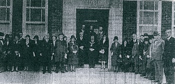
The School Opening Day in September 1931 with the Mayor and other dignitaries.
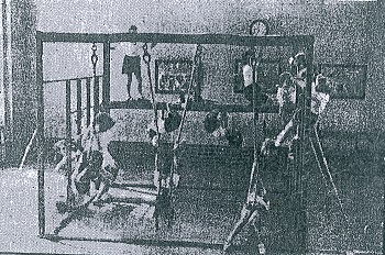
Pupils at the school enjoy the use of the gymnasium.
In 1928, the Society of Friends formed an Allotment Committee in Blackburn working with the National Society of Allotments to encourage people without gardens to grow their own fruit and vegetables to improve diets. Blackburn Council made land available at 11 sites with the largest being at Whitebirk which covered 50 acres. Its other aim was to aid unemployment to create the plots with lucky applicants being able to rent them. The Councils Social Services erected huts on the new sites and provided cheap seeds, fertilizers and tools for use on the allotments. In 1935, a Jubilee Club encouraged boys aged 14-18 years to get involved in horticulture and used the sites. The allotments show up on the 1956 O.S. Map just south of the Leeds Liverpool canal on former farmland in Whitebirk.
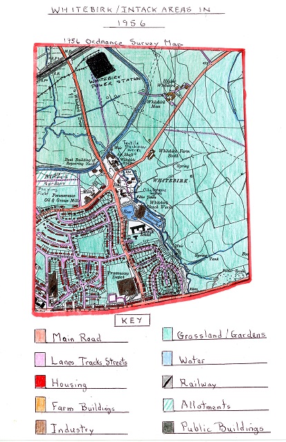
The 1956 Ordnance Survey Map of Whitebirk and Intack Areas
When comparing the 1956 map to that of 1931, the intervening twenty-five years show the Council has completed its huge housing estate between Burnley Road and Accrington Road on a large area of former farmland. Between 1945 and 1951, 557 council houses were built in the Intack area up to Accrington Road. Some open areas were left for recreation. Allotment gardens and playing fields to provide facilities for the huge increase in the population in the area. As a result of the new council house building, Intack Primary School required increased accommodation. Mrs Higham took over from Miss Bolton as headmistress in 1936. By 1952, the school had 469 pupils with an added classroom attached to the school. Where pupils once ate in the Main Assembly-Hall they now had their own canteen with the hall now used as a gymnasium as well as assemblies, and, for other events.
Of the existing businesses, T.J. Hodson Boat Yard continued under family ownership. By now, however, the canal traffic was lower in volume and they only operated one slip which now had a Belfast Roof over it. By the mid 1950’s, the yard had stopped building new boats and relied on boat repairs. The business continued to 1960 when traffic on the canal ended due to road transport development. Additionally, boats were now built of steel which the yard could not adapt to or manufacture. Whitebirk Bleachworks was now run by Barnes Brothers Ltd. It had 90 employees by 1956 including some long service workers bleaching gauze, surgical cloth and piece goods. At Davies Slaughterhouse all carcasses had to be transported on ventilated closed waggons. The works had also been instructed to lower the smells coming from their premises because, at times, the smell had been invasive. Mr. Bolton continued with his textile machinery parts business next to the Slaughterhouse. His main products being slays and warp tensions but with the decline in textile production, he now relied on export business.
The Eccles Perseverance Oil Works sited on Burnley Road had now expanded after the works were redeveloped. In 1946, Mr. Eccles was 80 years old, he had been associated with the works for 70 years and he still got up at 5am to oversee the work; he lived next to the works at Mostyn House. The George Broughton & Co. lubricant’s business was still on Whitebirk Road although during the WW2, oil supplies were commandeered for the war effort. In 1948, George and Edgar Broughton were joined by George’s son Rex by which time lubricants for the textile industry had dried up due to its decline. The company diversified into fuel oils to meet the growing market for motorised vehicles plus a growing domestic market for agricultural machinery. Vans were first used for deliveries but with increased trade they bought their first bulk tanker and shortly after introduced the brand name “Gebrol” a short version of the company name.
During the 1950’s the Bancroft’s Shuttle and Bobbin Works on St Ives Road expanded again now focusing on automatic shuttles for home and export markets used by automatic and semi-automatic textile looms. They also produced bobbins, picking sticks and other textile related products via nine factories in the Bancroft group.
The largest new industrial development in the area since 1931 was in northern Whitebirk. At the top of the map, on Philips Road, Blackburn’s first industrial estate was developed and opened in 1938, attracting new industry to the town because of the decline in the textile industry and the need to develop a diversified industrial base. The first firm established on the estate just off Whitebirk Drive was Mullards. It was first known as the Philips Works but later was named after its founder Stanley Mullard who first set up a radio valve company in Surrey. This new business was developed to manufacture wireless and domestic radio components. The business experienced an upturn with the outbreak of World War 2 with the huge demand for valves for radio communications and radar. Major production from its Mitchum works was transferred to Blackburn. In the first year it produced 60,000 valves, and, by 1940, within its 12 mills it was producing over a million. After the War, during the 1950’s, production and employee numbers rocketed. With the end of austerity millions of families obtained their first televisions all filled with valves. By 1954, the factory site had grown to 45 acres with 3000 employees, many of whom, were female. At the time, it was Europe’s biggest valve producer, and, by 1959, the number of valves produced rose to 57 million with a workforce of 4,500. Mullards had to farm out work to seven feeder factories in Lancashire which employed a further 1,500. As a result of this enormous growth Mullard, Blackburn became a vital industry for Blackburn’s economy.
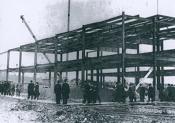
The new Philip’s factory being constructed.
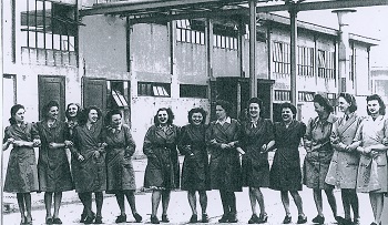 Mullard factory girls pose for a picture showing the growth of female labour force in the early 1950’s.
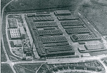
A 1954 aerial view of the vast Mullard site which had grown swiftly.
Another major firm attracted to the new Greenbank Industrial Estate below the Mullards site was British Northrop Ltd. The company started making automated textile looms in 1902 having evolved from Henry Livesey’s Greenbank foundry (see 1893 notes earlier). By 1956, this important Blackburn company exported looms to all cloth producing countries in the world. At the same time, the company constantly researched new designs for their weaving machines to advance their efficiency, creating a new range of single and multi-width machines. By 1956, all the Northrop operations were now taking place in one building on the industrial estate.
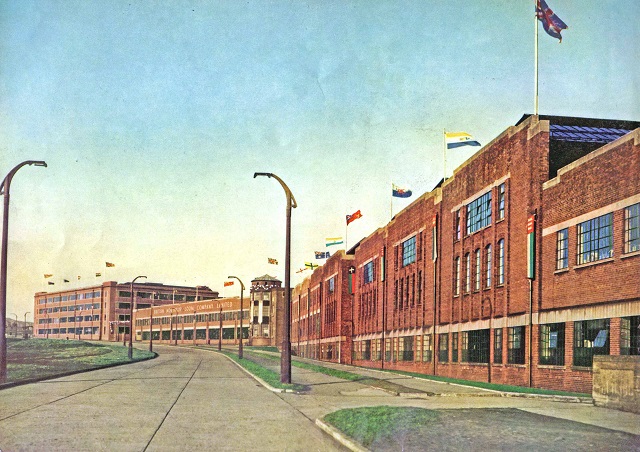
A view of the Northrop building on the industrial estate.
By 1936, Intack Tram Depot had become Intack Bus Depot, all trams having ceased service in 1949. The depot was extended and re-modelled to handle buses which were assembled and bought in from bodybuilders. They were maintained by a team of mechanics. Both double decker and single decker buses now operated Blackburn and Darwen routes.
At Whitebirk power station, the original wooden cooling towers had been replaced with concrete towers built between 1942 and 1954. The station continued to increase its electrical output both for the local market and for the National Grid using coal to operate its turbines. Most coal now arrived at the site from both road and rail routes. In 1947, two new giant alternators were fitted at a cost of £2 million, and, in 1948, the station passed from Blackburn Corporation to the North-West Electricity Board (NORWEB).
At the Greenbank Gas Works, the site continued to be extended to meet the increased demand for gas. Coal was still used to produce the gas. The site also had a large gasometer to store gas before it was moved locally into the now established National Gas Grid system.
Other changes in the area included women being trained to take men’s jobs during W.W. 2 including operating coal barges on the canal and helping at the Electric and Gas sites. In 1940, two German bombs fell harmlessly on land at Whitebirk between the electric power station and the gas works. By 1956, Whitebirk drive had been upgraded and made into a dual carriageway to meet the needs of increased road transport especially lorries being used to deliver goods directly to company premises and operating out of the same. After war time limitations, private ownership of cars had grown significantly. As prosperity levels rose, car and commercial vehicle manufacturers moved forward with more automation and new assembly line production to increase output and keep down prices.
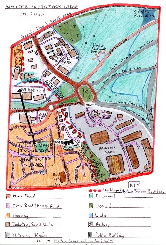
The 2024 Google Extract Map of Whitebirk and Intack Areas
The Whitebirk and Intack areas experienced a huge transformation from1956. Now, three-quarters of the once rural outskirts of Blackburn and Hynburn are now built up. Blackburn Council had to act after the demise of the textile industry, and, from 1956, actively encouraged a more diversified industrial base. On areas of open land or cleared land new industries and new housing were established. The pace of change started slowly and accelerated in the 2000’s, businesses were attracted to the new Retail, Industrial, Business and Technology Parks set up by the Blackburn and Hynburn Councils. Large areas of former farmland in the north-west and south-east and land, cleared from the former Electric Power station, were taken up by these new sites. Now, the area is dominated by a myriad of service industries, with the only manufacturing industry surviving being the Engineering Industry. All these new developments are almost exclusively housed in modern units of various sizes. Increasingly, as seen in the recent Frontier Park, becoming used for distribution centres relying on the proximity of the motorway, as road transport now dominates. Today, huge lorries and a wide variety of trucks and vans provide transport in and out of the area.
The M65 motorway was first proposed in 1969 as a means of direct transport from the Burnley and Colne areas to Blackburn and on to Preston. It was not until 1984 that the Hynburn to Burnley section was completed after many changes. The continuing section to Preston was formed by-passing Blackburn on its way to Preston. It was completed at the end of 1989 with its major interchange, junction six, at Whitebirk roundabout allowing access on and off it via four main slip roads from Whitebirk (Blackburn north) area. During 2007/8, Whitebirk roundabout itself was enlarged to four lanes and given full time traffic lights to help cope with the huge volume of traffic now using the system and to aid congestion at peak times.
At the same time, Whitebirk Drive, part of the orbital route round Blackburn, was further upgraded with more lanes and slip roads to link with the new industrial, retail and housing developments prior to its link-up with Whitebirk Roundabout.
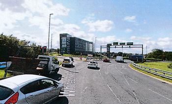
A modern view of Whitebirk Roundabout and traffic with the new Frontier Park
Industrial Park off to the right and the new Hilton Hotel
A large percentage of the increased volume of traffic at Whitebirk can be attributed to the huge increase service industries on the four designated Industrial/Retail/Business Parks and the huge increase of private ownership of motorised transport vehicles today.
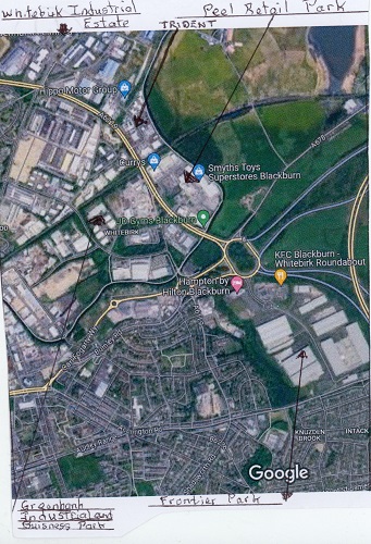
An modern aerial view of Whitebirk and Intack annotated to point out key places of the areas today.
The development of the new industrial, business and retail areas, the motorway its slip roads and Whitebirk roundabout have taken up large tracks of former open farmland. A new access link road developed through the Greenbank area was created to link up with Whitebirk roundabout called Carl Fogerty Way creating a junction with Burnley and Whitebirk Roads along which new service industry units will be developed.
Little new housing has been added to the areas and Lower Whitebirk Farm was lost with the development of the roundabout and motorway junction. The Intack council houses on the two estates were upgraded in the 1970’s, and again, in more re
3. Eccles Oil Works off Burnley Road closed in 1970, and the site is now used by various industrial units.
4. Whitebirk Bleachworks was first taken over by Staflex in 1972, but, by the late 1970’s was struggling and eventually closed. The site now houses by a variety of industrial units off Whitebirk Road.
5. Geoff Broughton’s oil business continued to more recent times but with competition from various sources the site was closed and demolished.
6. Bancrofts Shuttle works off Accrington Road closed in 1981 due to severe foreign competition and the site is now covered with new business premises.
7. Mullard’s site part of the Dutch Philips Group continued, and, in the 1970’s was still turning out 55 million valves a year. Production continued until 1982 whecent times by Blackburn Council.
The existing industry shown on the 1956 Ordnance Survey Map has all gone due to modern developments in both areas e.g -
1. The Boat yard closed in the 1970’s and the site was taken over by Carkes Caravan sales, which, in turn, closed with the modern road works at Whitebirk2. Davies Slaughterhouse also closed along with Bolton’s Textile Works and the site developed by a Pet Food Firm but in turn these moved with Whitebirk transport developments.n it was the last valve factory in the Western world but eventually closed with the site redeveloped removing most of its buildings off Philips Road. It is now a modern industrial estate within the giant Greenbank Industrial Estate.
8. At the same time, the American Northrop Company, also sited on Philips Road, closed, killed off by fall of the textile industry due to the loss of foreign markets. All the buildings were demolished and recently site is being developed with giant industrial units for new company distribution centres (probably) again within the huge Greenbank Industrial Estate.
9. Blackburn Council’s Intack Bus Depot remains, and, in the 1980’s, a £1 million scheme was started with Phase 1 involving upgrading the offices, fuel depot and open bus parking area. The original tram depot was demolished to make way for a modern building. Phase 2 was completed in the 1980’s.
10. During 1963, there was a time when the weather became very cold and the Leeds Liverpool Canal froze over for 13 weeks, as a result, some of the coal still brought by barge was further moved by lorry which ended the canal’s use. By 1976, the Whitebirk Power station stopped generating power from the site, and, by 1983, the station had been demolished with the first two huge 4000 tonne concrete cooling towers demolished in 1983 followed later by the removal of the other two.
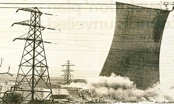
A picture showing one of the cooling towers of the former Power station being demolished
in May 1983. On the left you can see the base of a
second tower which had already been brought down
After the Power station site was cleared, Blackburn’s first retail Park was developed called Peel Park which is now known as Hynburn Retail Park, managed by Peel Holdings. All that remains of the old site is an Electric Sub-Station linked to the National Grid by pylons and still visible in the retail Park.
11. The Greenbank gas station was also demolished as gas supplies now came via the Gas National grid as gas supplies now came from Natural Gas Sites in the North and Irish Seas from off-shore Gas Rigs, or, is imported in liquified form.
As mentioned earlier, the largest change to the area was the creation of four industrial, business, technology, and retail parks in Whitebirk which are as follows -(A) WHITEBIRK INDUSTRIAL ESTATE – the first to be created by Blackburn Council based off the top of Philips Road with crescent shaped access roads off it to the numerous companies based on the site next to Whitebirk Drive and its connection to the M65 Motorway network. In total, it houses over 35 companies with the largest including Blackburn Chemicals, Achme Refrigeration, Premier Steel, H & T Pressparts, Pets Choice, Promethian and Auto Choice. The majority are service industries with some engineering and one sewn products firm.
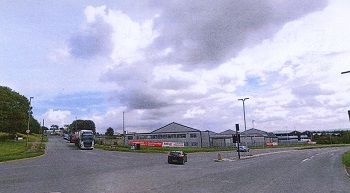
The entrance to Whitebirk Industrial Estate off
Whitebirk Drive which is shown in the foreground
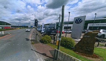
A view of Trident Way, the central access road in the park with Lookers VW car sales centre
(C) HYNBURN RETAIL PARK – formerly Peel Park and now managed by Peel Holdings who own the site which is also off Whitebirk Drive. This site was developed on the site of the former Whitebirk Power Station and still contains an electric sub-station. It was first developed in the 1980’s although many of the original occupants of the newly built units are no longer there including MFI and Payless shown on the aerial photo below. At present, the main retail businesses on the site are Curry’s (Electrical), SCS (Home Furniture), Prestige Beds, Howdens (Joinery and home improvements), Dreams (Beds), Wren (Kitchen and Bedroom Furniture) Smyths (Toys), J.D. Sports, Iceland Warehouse (Food), B&M Bargains (Food & Household Goods), Aldi (Supermarket), Home Bargains (Supermarket) JD Gym’s, Costa Coffee and Sofology (Home Furnishings) . Peel have tried unsuccessfully to persuade Hynburn Council to allow them to expand the park without success as they felt it would affect Accrington shops and stores.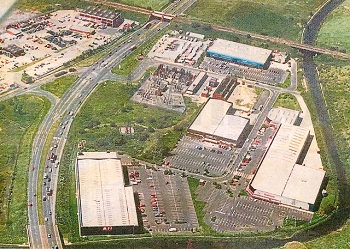
An aerial view of the original Peel Retail Park in the 1980’s with MFI (DIY) store on the bottom left,
Payless in the centre (now Aldi) and Queensway Carpets on the right by the canal
and the electric sub-station near Whitebirk Drive. On the left side of Whitebirk Drive
can be seen North-West Electrics depot in the Greenbank Industrial Estate. A modern view of the B & M and Iceland warehouse stores within the park.
(D) GREENBANK INDUSTRIAL and BUSINESS PARK – this is by far the largest park extending from Whitebirk Roundabout to the north of the 2024 Google Map to Philips Road. It has main access roads namely Blakewater, Greenbank and Philips and Challenge Way, off which are numerous crescent shaped minor access roads to the commercial units. The park was developed by Blackburn Council to offer more diversified industries to Blackburn and contains many companies mostly housed in modern units apart from a few on the old Mullards site. Some of the largest industrial business and retail sites include Mercedes (Marshall’s). Ford Centre, The Range, Khanjra International (Food Supplies), Silicone Engineering, The Police Headquarters and the Electricity North-West Distribution Centre that covers the largest site together with its own Training Centre. Other large sites include EMR Recycling, MK Transport (Heavy Haulage) with large new units being created near the old Imperial mill and on the old Northrop site. Within this large park are other specialist areas:
(1) Blackburn Technology Centre where 14 offices are occupied with the larger units taken by Greenbank technology Centre, Blackburn College, Saturn, Whitebirk Sink Co., Technology Management Centre and some large units under construction.
(2) Atlas Park (Adnam’s) which houses Sage, C&B- commercial vehicle supplies, BEC, Direct Sips (Wood supplies) and accountant/finance offices.
(3) Mullards old site – the largest units include Graphix (printed signs), Europapers, Crown optical and Ribble Business Park which houses the Artificial Grass Co., Ribble House Business Centre
A view down the main access road in Greenbank Industrial Park called Challenge Way
(E) FRONTIER PARK – the most recent industrial development owned by the Issa Brothers stretching from Whitebirk Roundabout to Intack and Accrington Road with a main through road called Frontier Avenue off which are access roads to the new site’s units. This is a mixed development with retail units for food outlets including Greggs, Subway, Starbucks and KFC. It also has the new Hampton Hotel owned by the Hilton Group on a large prominent site off the Whitebirk roundabout and entrance to the park. Other large modern units on the site are operated by distribution firms including E.G. Garages, Staci, Alufold, Tec Dry, Science in Sport, Fagan and Whalley Freight Depot, Frontier Park Depot and Taziker.
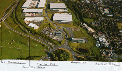
An annotated aerial picture of Frontier Park’s location.
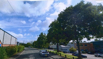
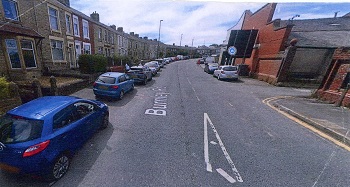
(F) Whitebirk Road Developments in the Intack area shown below are-
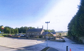
The Mylahore Indian Restaurant in the old Red Lion Hotel and the sign for the
McDonalds Restaurant behind both sited by the link road leading off from Whitebirk Roundabout
An old industrial building shown on the right which is now divided into units for motor
vehicle repairs with the original Burnley Road terraced houses shown on the left of the picture
Blackburn is to develop a new muti-million-pound estate of affordable homes for rent on a new Whitebirk Park Estate in partnership with Social Housing provider Together Housing and the Place Capital Group. The new estate will have 152 homes including 46 one-bed apartments, 45 two-bed houses and apartments, 54 three-bed houses and seven four-bed houses. The new estate will be based on the existing Hereford Road, Worcester, Brecon, Devon and Gloucester Roads of the existing post war council estate mentioned earlier in this article with the existing houses being demolished to make way for the new ones. The proposals, following consultation with the local residents, will include millions of pounds of investment in the wider Whitebirk and Intack community, including upgrades to green spaces such as the park off Hereford Road. It is intended that the new housing will have solar panels and source heat pumps to keep bills low and meet energy efficient guidelines.
The updated developments displayed by the 2024 map show just how much the Whitebirk and Intack areas have changed in modern times leaving little evidence of their historical past.
Resources
The author's own local history collection
Barrett’s Trade Directories – various years held in Blackburn Library
Beattie, Derek, Blackburn: A History, Carnegie Publishing, 2007
Notes on Whitebirk, E02 Whi (Bound Newscuttings, Blackburn Central Library) plus a range of general news cuttings held in Blackburn Central Library
Ordnance Survey Maps (Blackburn Central Library) plus Google Maps
Rothwell, Mike, Industrial Heritage: A Guide to The Industrial Archaeology of Blackburn. Part One: The Textile Industry, Hyndburn Local History Society, 1985
Rothwell, Mike, Industrial Heritage: A Guide to The Industrial Archaeology of Blackburn. Part Two: Other Industries, Hyndburn Local History Society, 1968
Timmins, J.G. Handloom weaver’s cottages in central Lancashire (Occasional Paper), Centre for North West Regional Studies, University of Lancaster, 1977
The Victoria County History of Lancashire