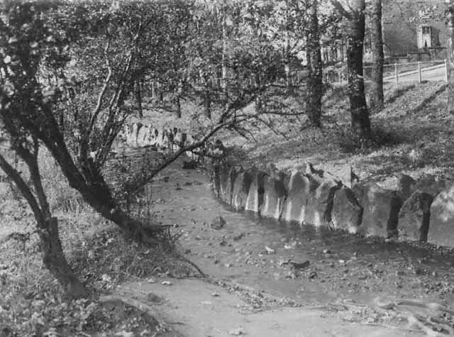
Brownhill Plantation and the improved stream banks to contain the flow of water
The 1894 map also shows an extended open area of land alongside the railway line in the southern area of Roe Lee with a track leading off the road towards nearby Roe Lee Mill providing good access to it.
A housing boom started in the 1880’s, and local quarries made pre-shaped blocks of stone for windows and doorways in brick built terraced house. In the early 1890’s the map shows terraced housing extended laterally along the side of Whalley New Road towards Brownhill, these were both larger and of better quality. The earliest terraced housing around Roe lee Mill and at the southern end of Whalley New Road near Florence Mill and the cemetery, typically had doors opening onto pavements. However, larger terraced housing built by 1893 shows they had small front garden and sometimes a front bay window alongside a larger back yard.
Terraced houses and front gardens on the northern side of Whalley New Road in Roe Lee
In 1894, Cornelian Street and Agate street were the only terraced housing not directly on Whalley New Road, apart from those built near Roe Lee Mill.
Industry at Roe Lee, which was primarily textiles, had expanded and in 1902 Duckworth and Eddleston of Carr Cottage Mill in Little Harwood took over the running of Roe Lee Mill which now had 815 power looms. The map shows that the mill had two small reservoirs at the front of the mill connected to the passing stream which supplied water to its steam powered machinery. In 1906 Roe Lee New Mill was built alongside the old one as a self-contained weaving mill, partly financed by William Birtwistle. It had 640 power looms later increased to 828 and was powered by a 450 horse-power horizontal compound engine with rope drive produced by Ashton Frost and Company. The two mills were run by John Duckworth and Eddleston.
In 1913, on the 10th July, King George V and Queen Mary visited the mills as part of a visit to Blackburn. They met the firm’s partners together with Lord Derby to inspect the mills and see their production processes in the Winding and Warping Room, the Sizing Room, the Drawing-In Room, the Weaving sheds and the warehouse. In the weaving shed they saw various processes for fancy fabrics, and in the warehouse a display of the companies various finished textiles. The Wilpshire Prize Brass Band was in attendance, after the event there was a display of fireworks.
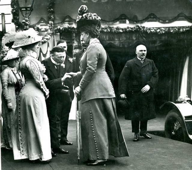
The co-owner John Duckworth greeting Queen Mary at Roe Lee Mills
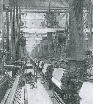
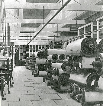
Rows of power looms inside Roe Lee New MillThe side of a power loom and its drawing belt driven by steam power
 Inside the warehouse with the finished rolls of textiles
Roe Lee textile mills and their chimneys with terraced housing behind
Shortly after 1894, a new textile mill was built in Roe Lee by Blackburn Mill Building Company on the site of the former Haston Lee Farm. It was a weaving shed opened in 1912. This brick- built mill was leased by Herbert Slater of nearby Florence Mill and had 616 plain calico power looms operated by a Livesey, Yates and Thom boiler (local firm), with a 350 horse-powered horizontal cross-compound engine by Ashton Frost and Company. The firm had 250 workers who wove dhooties, sateems and twills, plus other fancy fabrics. Haston Lee Mill had an eight-bay warehouse with the loading bays covered, facing Emerald Avenue. It also had a two-storey tape sizing room and weaving sheds on an elevated position.
Haston Lee Textile Mill at the side of Emerald Avenue
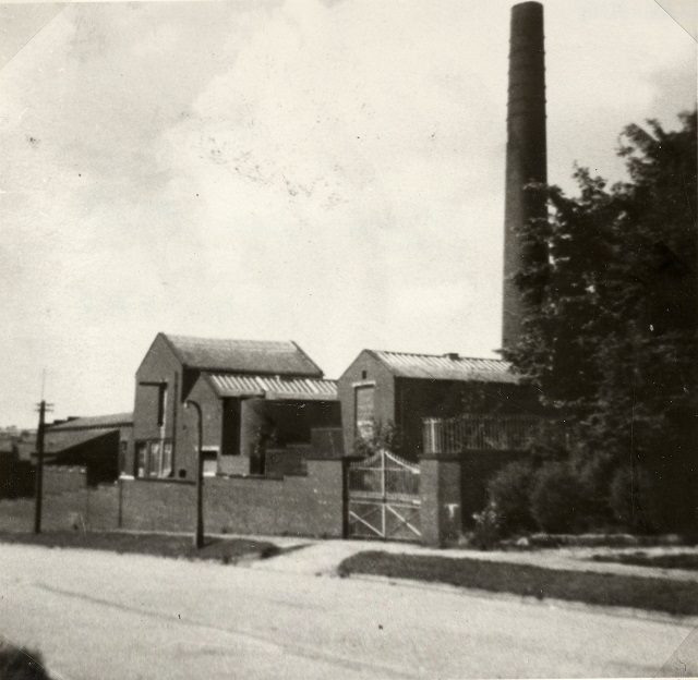
Another textile-related industry developed in Roe Lee and shown on the 1894 map was Crystal Bleach, works sited on Pearl Street. It was started by John Higson and James Byrne to bleach waste textile fabrics, it was run by a thirty-five horse-powered horizontal engine. The machinery broke up waste fabrics which had been boiled before placed in bleach tanks, the map showes the mill had a good water supply as a local stream passed through it. Later, Higson went bankrupted, and from 1896 various bleaching firms took over the business, with Kershaw and Company taking over in 1905 and converting it to textile piece dyeing.
In 1888, a church mission was started by the Reverand S.F. Harris in a cottage, which soon became overcrowded. Land was acquired on Pearl Street off Whalley New Road and an iron church was erected by the Reverand W. Thomason which was opened in 1889 by Bishop Cramer-Roberts it is shown on the 1894 map. This acted as a church and Sunday School. By 1900, the districts population had risen so much that a new school was built for St. Gabriel's Church on the original site. Plans were approved by Blackburn Education Department and the foundation stone was laid in July 1900. The building consisted of a school room two classrooms, with a chancel at one end, the cost was approximately £2500. This new school was in the parish of St. Michael and All Angels, with teachers drawn from St Gabriel's and Pleckgate. Sir Henry Hornby, the Textile magnate of Brookhouse Mills, performed the ceremony when the foundation stone was laid, he was thanked for his donation of £100 towards the building costs. In 1901, the school was opened on Cornelian Street, headmaster was Mr. Robert Wilkinson. The early education for the area was first started at the St. Chads Church in Pleckgate and then continued in the Roe Lee. A log-book of the school had entries which gave an insight into early school life as show in the list below: -
1865 – reference was made to various poor behaviours including impertinence, swearing and fighting which led to various punishments.
1895 – many children were away from school in July/August working in the hay fields.
1898 – scholars were now coming to school much cleaner and wearing collars.
1902 – as trams were now running to Wilpshire the children were warned not to play on the tram lines.
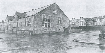
The original school/church mission building on Cornelian Street which became St. Gabriel's Primary School
By 1894 into the early 1900’s, some local farms started specializing in poultry farming, as large scale egg production could be achieved on a small piece of land to meet the rising demand for eggs and dairy products. Although farmland had been lost, there was still large areas of open fields, as most developments had been alongside Whalley New Road.
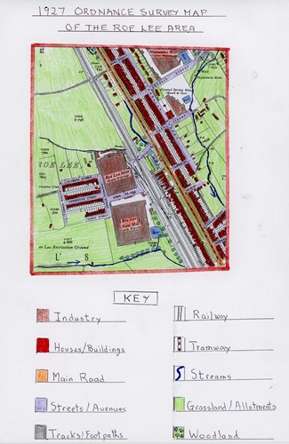
The 1927 Ordnance Survey Map of Roe Lee
The above map shows the Roe Lee as it was 33 years after the last map and represents the Inter-War years between 1918-1939. Due to the war and its effects, there had been less change in the Roe Lee area.
Industry in the area was still dominated by textiles, which had grown mostly before First World War. A second cotton weaving mill at Roe Lee is now visible with its own reservoir. The company was re-organised in the 1920’s by John Duckworth (Blackburn) Ltd. John Duckworth was a staunch liberal, he was the last Blackburn-born man to represent the town in Parliament.
In 1924, a weaver called Mr. C. Gregson was dismissed for being 6 minutes late for work due to the weather, which caused the Roe Lee Mills workforce to consider striking, especially as he had been a loyal worker for 16 years. At that time however, weavers were often victimised and harshly treated, especially when the trade became difficult with textile depressions.
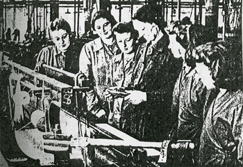
Young weavers being given instruction in the weaving shed of John Duckworth and Son (Blackburn) Ltd.
The market had changed by 1927 and Roe Lee mill had moved into producing brocades and quality jacquard weaving products.
1920-21 saw Haston Lee weaving mill expanding, with a small extension having been built to house 50 more power looms. Herbert Slater, the mills owner, retired in 1927, and the mill was sold to John Bury and Co. Ltd. of Accrington, with spasmodic production continuing until 1936, when Vale Manufacturing Co. Ltd., also of Accrington bought the firm.
Power loom weavers at Haston Lee Mill in the 1930’s
The map shows that Crystal Spring Works had expanded, with the business having its own reservoir fed by a passing stream to provide steam power to operate the dyeing machinery and the hydraulic ram (see map) to control the streams flow. By 1935, however, the business had been sold later becaming a rubber works.
Florence Mill at this time continued with little or no change, other than suffering from inconsistent production due to the war and later depression.
The map shows that housing in the Roe Lee area had increased in the late 1890’s and early 1900’s prior to the First World War. Spaces along Whalley New Road had now been infilled with new terraced housing, all with small front gardens and often with bay windows. The part of this development alongside Whalley New Road nearest Brownhill saw the houses increasing in size (villa terraced). At the same time rows of terraced houses were developed behind the ones along Whalley New Road (back-to-back), all accessed by new streets named after gemstone linked to Cornelian Street, which ran parallel to Whalley New Road. This growth mirrored the growth of the Textile Industry at this time, but after First World War no new houses were built in the rented sector so Blackburn Corporation decided to build council houses for renting. In January 1917, a scheme to build five hundred houses with Government assistance began, with 172 of these located in the Roe Lee Area. These were built in the northern sector, all were semi-detached with front and rear gardens, and modern facilities, including inside toilets and bathrooms. Some of these new council houses can be seen on the map off Cornelian Street, they extended round the newly developed Roe Lee Park and Brownhill. On the left side of Whalley New Road beyond Roe Lee Mills can be seen two pairs of privately built semi-detached houses. At the southern end of Whalley New Road, just beyond Florence Mill on the edge of Skew Bridge, was another council house estate developed off Rosewood Avenue.
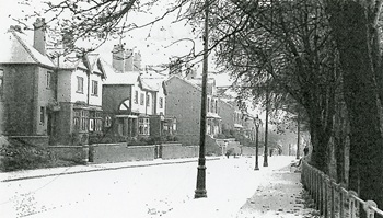
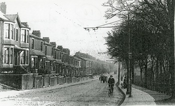
Edwardian terraced houses at the northern end of Whalley New Road showing large bay windows
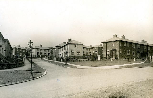
Semi-detached Council houses built on Rosewood Avenue where it meets Briar Road
After the visit of King George V and Queen Mary to Roe Lee Mills in 1913, the owners Duckworth and Eddleston gave sixteen acres of land to the town for creating a public park for the residents of Roe Lee. Roe Lee Park was opened on the 30th. May 1923 by John Duckworth JP and John Eddleston JP of Roe Lee Mills to commemorate the Kings visit to Blackburn. To mark this special occasion, the mill owners gave their workers at the mill a half-day holiday, and flags were flown the mills. John Duckworth officiated and opened the parks new pavilion with a gold key. The park began with five tennis courts, three bowling greens and a putting green, with a variety of shrubbery and grass areas. It was surrounded by the Borough semi-detached council houses like garden city styled developments in tree-lined roads with the landscaped park on its doorstep. Roe Lee Parks bowling pavilion was built by Fecitt and Sons in 1923 and was well equipped for tennis and bowls players and had a refreshment room. A four-dialled clock was inserted in its tower which was visible from all parts of the park, and later a children’s paddling pool was added to the park’s attractions.
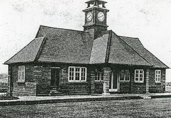
Roe Lee Park’s pavilion with the bowling green in front and the clock tower
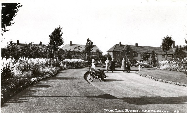
Roe Lee Park’s main pathways with shrubbery and nearby council houses
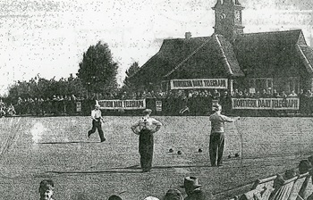
A large crowd watches a bowling match at Roe Lee for the Northern Daily Telegraph Cup
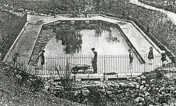
Children’s paddling pool in the park with landscaped land around it
At St. Gabriel's Primary School on Cornelian Street, the map shows there are now two playgrounds separated by a wall for girls and boys to have their own play areas, with a separate building divided, which was the outside toilets for each playground. In 1917, the pupils of the school were engaged in making sandbags for the army, with the pupils working during school intervals and at home to help First World War effort.
During 1932, many of the school’s pupils went to the ceremony of laying the Foundation Stone of the new St. Gabriel’s Church to be built at Brownhill, the church was consecrated by the Bishop of Burnley in April 1933, followed by a Children’s Service. This ended the use of the primary school as St. Gabriel's Church.
Roe Lee Park Council Primary School was opened after the park was developed and the large Council house estates had been built in the late 1920’s to meet the needs of the growing population in the Roe Lee. It was the first post-war school to be built in Blackburn, its site covered four and a half acres, bounded on the north and west by Roe Lee council estate and partly on the east by the new arterial road connecting Whitebirk to Brownhill. The school had separate entrances for boys and girls from Emerald Street, and access to its playing fields outside school hours from Brownhill Drive and Beryl Street. Roe Lee School had paved playgrounds, a full-sized football pitch for the boys and a hockey pitch for the girls, together with school gardens. A new progressive function of the school’s classrooms was they could be opened to an outside quadrangle to enhance the quality of sun and air which they could enjoy. When designed the school was arranged to allow for future extensions so it could, if needed, double its size. Inside the school, the staff room, assembly hall, waiting room and medical inspection room were all in central positions so they could still be accessed if the school expanded. The school also had a modern heating system with two controls in each classroom, together with grand wood block floors.
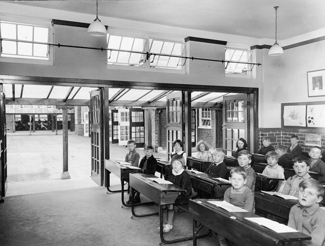
A classroom at Roe Lee Primary School with the doors opened to an outer quadrangle for maximum air and sun
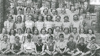
Infants Class at Roe Lee Primary School in 1929
the doors open and equipment on view
The 1927 map shows other changes to the landscape, especially the field patterns, due to increased developments in the area reducing the amount of farmland, especially on the east side of Whalley New Road. As a result, fields declined and allotments increased. The fields were small as were the buildings, probably huts with some greenhouses, particularly north of the Roe Lee Mills housing. The increased demand for locals to grow their own fruit and vegetables was especially heightened during First World War. Groups of these developments can be seen south of Crystal Spring Water Works, with most of the allotment land being rented off the landowner.
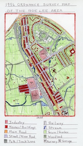
The Ordnance Survey Map of the Roe Lee Area in 1956
This map covers the post-Second World War period, when new developments from 1927 were slow to occur as the country recovered from the effects of the war both economically, and in human terms.
The main changes over the proceeding 29 years post-Second World War, on the map are some infillings of areas with new housing, such as along Emerald Avenue, Cornelian Street and the completion of the council housing estate around Roe Lee Primary School. These new houses enjoyed better facilities than those of the Victorian and Edwardian eras. As a result of the new housing developments, there was increased urban areas to the east of Whalley New Road with the loss of many of the previous allotment areas, although more greenhouses are seen in the area north of Roe Lee Mills housing. Any farming continued in this period would be confined to the small area north of Roe Lee Mills, but there had been a considerable increase in woodland, especially in Roe Lee Park, as earlier saplings had now matured.
Due to the improved working conditions of this period and increased leisure time now being enjoyed, locals had a range of activities available apart from those in Roe Lee Park. there was now a new Roe Lee Recreation Ground with its own pavilion south of Roe Lee Mills probably used for football and cricket by local teams as the Roe Lee population continued to grow or they belonged to Roe Lee Mills for their employees. At the same time a playground area of grass with a rectangular hard area had been created at the southern end of Roe Lee Park off Emerald Avenue.
On the industrial front the Textile Industry entered a post-war depression from which it never recovered from the effects of the Second World War. This was due mainly to the increased competition from Asian countries which had previously been the main export market for Lancashire textiles. These countries had developed their own thriving textile industry helped by the import of machinery from Lancashire mills that had closed or upgraded to more modern machinery. The remaining textile mills now had to concentrate on producing clothing, industrial and more upmarket fancy goods, and employed mostly female workers which started during the war years. Production of textiles at Roe Lee Mills had reduced, and because more modern electric textile machinery was now available there was much lower numbers of workers as the industry became more automated. Haston Lee Mill and Florence Mill were still surviving, but at reduced levels, now producing a much wider range of materials.
During the Second World War, Florence Mill acquired a plot of land from the cemetery to build an air-raid shelter for its workers. Crystal Spring Works was now Pearl Street Rubber Works (non- textile). In 1956, the Service Industry had increased in the area, with shops, especially along Whalley New Road, providing a whole variety of goods for the local community.
The areas first garage which indicated how motorised transport, especially trucks and cars, had grown enormously, which in turn, led to Whalley New Road being widened in places and the surface being improved. The arterial road was now fully completed and made into a dual carriageway, so local industry could now move goods more easily to markets.
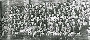
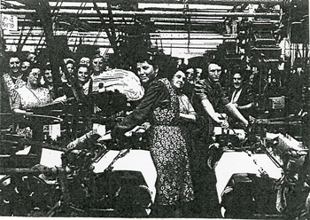
A group of female operatives from Roe Lee Mills posing for the camera in the 1950’s
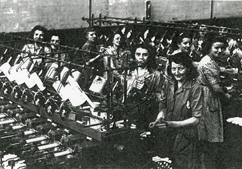
Female operatives hard at work on modern machinery at Haston Lee Mill in the 1940’s
On the education front, Roe Lee Primary School now had a new extension to cater for increased numbers of pupils from local areas. Off Emerald and Pearl Streets two new nurseries had opened, as a sign of the times when young children could be left when their mother went out to work, to enhance wages coming into the home as standards of living rose. St. Gabriel's Primary School on Cornelian Street continued in cramped conditions, as demand put pressure on its limited facilities.
A class of school leavers from Roe Lee Primary School in 1946
The main changes that occurred on the religious front saw the building of St. Gabriel's Church at Brownhill, ending the use at St. Gabriel's Primary School as a place of worship. Another new development was the building of holy Souls R.C. church close to the cemetery to cater for Roman Catholics in the area.
The 2025 Google Map of The Roe Lee Area
Today, 69 years since the 1956 map, Roe Lee has gone through huge changes, with its housing stock almost doubled, resulting in the area becoming completely built up and urbanised. On the industrial front, there is no longer any large-scale manufacturing as the textile industry has long since died and been replaced with much smaller and more diversified service industries. At the same time, farming in the area has gone, farmland being eaten up by these new developments. Primary education in area has also changed, with both St. Gabriel's and Holy Souls Schools moving to newly developed sites
The demise of the Textile Industry in Roe Lee mirrored the loss of the industry in most areas of Blackburn, brought down by cheaper foreign competition, especially from their former main markets in Asia. Florence Mill, that was taken over by the Birtwistle Textile Group, was closed in 1971 and became a footwear and slipper manufacturer with the Liverpool Shoe Co. Ltd. Today, however, like other local mills, it has been split into smaller units rented out to various small companies. Similarly, Roe Lee Mills were first taken over by Viyella International in 1964, who added a beam dye house and equipped it with new automatic looms to produce more specialised textiles, but by 1980 weaving ceased at the site and production ended in 1981. In more recent times, the old mill was demolished, and its site remained unused, although there are now plans to build industrial units there. Roe Lee New Mill has been transformed into Roe Lee Business Centre, with a whole range of smaller firms, mostly service industries, renting units. Several companies attempted to keep Haston Lee Mill and its textile work going, including the installation of automatic looms in the 1950’s producing a range of different fabrics. However, it closed in November 1980. Today, it’s weaving sheds have been demolished and large new extensions added to the remnants of the old mill, forming Vale Mill Business Park, with numerous small units rented out to a variety of mostly service industries. The variety of service industries in the former textile mills new units include electrical, motor vehicle services, motor parts and services, furniture, printing and the only manufacturing today being small scale specialized engineering.
Along sections of Whalley New Road can be found a variety of shops offering services to the residents and some larger units built on the west side including a carpet sales outlet, a Tesco Express Supermarket, a doctors practice, a Funeral Directors and an outdoor equipment store.
The original Knowles Arms was an old public house located on lower Pleckgate Road, which was demolished and replaced with a new public house on the fringe of northern Roe Lee. Over time, this has evolved into a popular restaurant presently run by Ego, with extensive car parking in a prime position alongside Ramsgreave Drive.

The former Roe Lee New Mill now Roe Lee Business Park
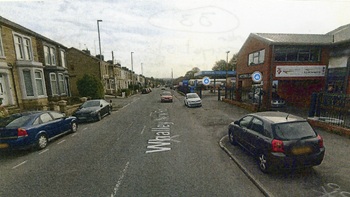
The modern carpet showroom and other service industries beyond it alongside Whalley New Road
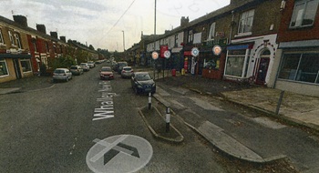
A row of shops offering a variety of services on Whalley New Road
New housing has increased enormously in the Roe Lee over the last 69 years, starting slowly with new developments in the 1970’s and increasing on a large scale in the 2000’s, especially of late. This is partly due to Government intervention responding to the lack of affordable housing in the country and relaxing planning requirements for new developments. There has been little or no further Council House building in the area since 1956, with most building developments operated by private builders. In the 1970’s, however, the council spruced up their housing stock, resurfaced roads, added new street lighting and generally tidied up their areas. Another development in the “Thatcher Years” people who rented council houses were encouraged to buy up their property at attractive prices, which proved popular and increased the private housing stock.
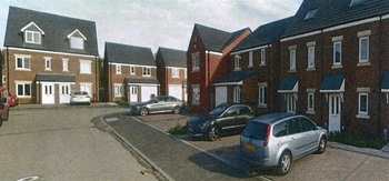
In very recent times, the “Blossoms Development” in the northern area of Roe Lee has added almost 300 new houses, including segments called “The Oaks”, “The Ferns”, “The Willows” and “The Limes” all consisting of a mixture of modern housing including Town Houses, Semi-Detached and detached properties offering attractive locations. To the south of Roe Lee Park, the areas have been totally infilled with numerous crescents, cul-de-sacs and roads containing affordable housing. Semi-detached, town houses and some detached properties have been built to the south of Roe Lee Business Park. This has resulted in the Roe Lee suburban area being mostly built up, and due to the modern reliance on the motor car, most new properties have parking facilities, garages or parking areas. To accommodate all this increased housing and private transport, the area is now criss-crossed by a network of new streets, crescents and roads.
A variety of housing types at “The Limes” housing estate with parking facilities
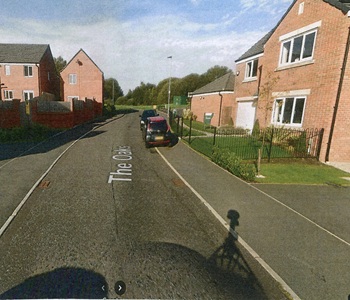
Modern housing on “The Oaks” housing estate showing gardens and parking facilities
In 1979 and onwards, there was a phased move of pupils from the old St. Gabriel’s Primary School on Cornelian Street to a new purpose-built primary school off Pleckgate Road and Wilworth Crescent, and then the old school closed. The old school then became a special school for pupils with behaviour problems for several years, but after a period of remaining unused, is now a private home and upgraded.
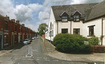
St. Gabriel's Primary School now modernised into a private house on Cornelian Street which still has its original terraced houses
In a similar move, Holy Souls Primary School re-located from a site next to the cemetery to a new site off Wilworth Crescent and Pleckgate Road to become a neighbour of St. Gabriel's Primary school.
Roe Lee Park has seen many changes since 1956 to meet the ever-changing needs of the area. Its tennis courts were closed, and today only two bowling greens are used, with the lower ladies’ green having a separate bowling hut. Close by, a modern children’s playground has evolved, offering a variety of equipment, and an additional youth area created and fenced off with an artificial surface ideal for ball games, especially football, Today, the park has a group of volunteers who, along with the council staff, look after the park’s facilities.
An aerial view of Roe Lee Park in its central location now with mature vegetation
By 1959, all the available space in Blackburn Cemetery in Roe Lee had been used up. In 1943 land for a new cemetery had been obtained in Pleasington and slowly developed into a new Town Cemetery. In the late 1950’s, the Church of England and Non- Conformist Chapels on the old cemetery being unused were demolished. Over the years, many of the old gravestones were neglected and some removed to allow modern machinery to cut the grass, and more recently the cemetery has suffered from vandalism and health and safety issues in respect of insecure headstones. Today however, a group of volunteers help to keep the area tidy and keep historic graves’ history available for the public.
Resources
The author's own local history collection
Barrett’s Trade Directories – various years held in Blackburn Library
Beattie, Derek, Blackburn: A History, Carnegie Publishing, 2007
General news cuttings held in Blackburn Central Library
Ordnance Survey Maps (Blackburn Central Library) plus Google Maps
Rothwell, Mike, Industrial Heritage: A Guide to The Industrial Archaeology of Blackburn. Part One: The Textile Industry, Hyndburn Local History Society, 1985
Rothwell, Mike, Industrial Heritage: A Guide to The Industrial Archaeology of Blackburn. Part Two: Other Industries, Hyndburn Local History Society, 1968
The Victoria County History of Lancashire
Cottontown : various images
Published February 2026