Witton Eyes Days Gone Bye
by
Mike Sumner
Originally Witton developed as a small hamlet in a rural setting on the ancient route from Blackburn to Preston, slowly developing into a village then during the Industrial era of the 19th century to a township. By 1877 it had been incorporated within Blackburn Borough and as a populous suburb had seen its population rise from 461(1801),1073(1841) to almost 4000 in the 1870’s. Witton Township is situated on the west side of Blackburn close to Redlam, Wensley Fold, Mill Hill and Cherry Tree areas. It occupies the north and south slopes of Billinge Hill with its southern boundary being the River Darwen and covers 650 acres, with its populous area being in the lowest south close to the old Blackburn to Preston route. Just north of the present cross-roads of Buncer Lane, Redlam, Spring Lane and Preston Old Road was the site of the old public stone stocks where the original track of Buncer Lane entered Redlam and remained there until approximately 1870 giving the area its name of “Witton Stocks.”

1848 map of Witton showing Witton Eye’s at the bottom right.
Witton Stocks 1848.
Witton Stocks showing Witton Avenue (later Spring-lane) to the right.
On the left was the site of the stocks and the original exit from Buncer-lane.
Map of Witton 1848 showing site of the old stocks and the original sight of Witton Athletic football ground.
The Witton area has been dominated by two major landowners, first the old Blackburn family of Astleys from the Mill Hill area who built Witton Old hall possibly in the 17th century to the rear of the present St. Mark’s Conservative Club, but by the 1870’s it was a ruin (see 1848 map). The next landowner was the Feilden family who had connections to Blackburn from the 16th century when Henry Feilden was named trustee for lands bequeathed by the Earl of Derby to a chantry of the parish church. Henry Feilden married Elizabeth Sudell from another important Blackburn family in 1721 and in the same year together with her father William Sudell and William Baldwin purchased the lordship of Blackburn from lord Falconberg. As a result he became a powerful figure residing in the original manor house adjoining the parish churchyard at the foot of Churchgate on the site of the present Yorkshire Bank on church Street.
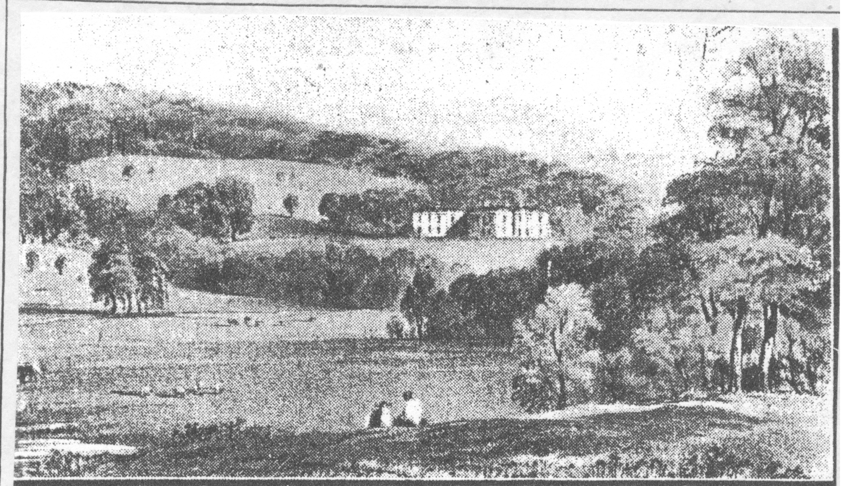
View of Witton House and the Witton Estate.
In 1800 Henry moved to Witton Park having bought estate lands there and built Witton House which was later developed into a stately mansion by his son Joseph using wealth gained from his lands and early textile industry close to King Street. Spacious grounds were laid out surrounding the house with thousands of trees being planted. The house was described as an elegant Georgian styled stone building being situated on a ledge of the lower Billings slopes offering expansive views over the parkland beyond. Large areas of the estate’s pasture land were leased out to tenant farmers. Joseph also helped fund and provided land for the building of Witton’s church (St. Mark’s) in 1858, a boy’s school/Sunday school in 1825 and the original Conservative Club at the corner of Witton Avenue later called Spring Lane.
Sketch of Witton boy’s School and Sunday School in 1825.
Witton-avenue looking from Preston Old-road. It was then a
private road leading to Mill Hill, with high stone walls.
By the 1920’s Witton house having not been fully lived in for some time became neglected and the family negotiated with Blackburn Council to take over the ownership rights to Witton Park and the house for £70,000.
Some of Witton Stocks oldest tenements when it was merely a hamlet were sited to the rear of the old stone stocks close to Buncer Lane’s original lower track section which had crossed the River Blakewater (see photo) and was the site of a famous murder of a little girl called Alice Barnes in 1892.
Old crossing of the Blakewater by track from Buncer-lane leading
to Witton Stocks and site of the murder of 9 year old Alice Barnes in 1892.
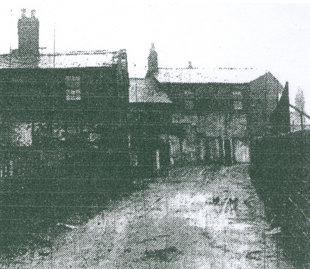
View from the old bridge leading up to Witton Stocks and Preston Old-road,
with the original tenement buildings.
At this time Spring Lane was a private track to Mill Hill later upgraded to Witton Avenue linking to Witton Bank and Griffin Lodge home of textile magnate Thomas Dugdale and his Witton Textile Mills, eventually becoming Spring Lane and linking to Hollin Bridge Street and on to Ewood.
Witton Avenue looking from Mill Hill, Witton Bank on the right and the road into Mill Hill leading
onto Darwen on the left.
At the same time the lower section of the present day route of Buncer Lane was also created. Thomas Dugdale was first elected to serve on Blackburn Town Council in 1851 and became Blackburn’s third mayor (1853-55). He was also chairman of the Lancashire Yorkshire Railway Company (this resulted in Blackburn getting it’s first railway link), the Manchester and County Bank, Blackburn’s Waterworks Co. and also helped to develop Dugdale Crown Green Bowling club.
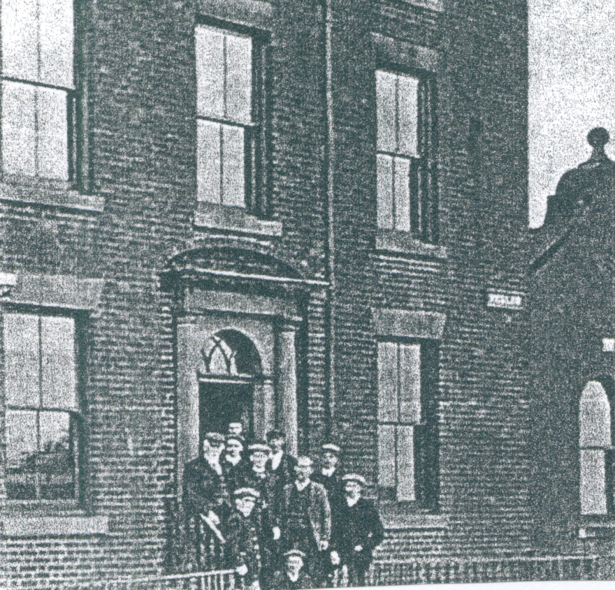
Witton Conservative club, originally sited to the left of Spring-lane.
The building was demolished to allow the widening of Spring-lane
and moved to St. Mark’s Conservative club lower down the road.
Just off the Preston Old Road end of Witton Avenue was sited Witton Athletic Football ground whose side were well known and successful in the early days of football playing both Blackburn Olympic and Blackburn Rovers sides in early local leagues and still exist as a football club (see 1848 map) This football ground was built on the north-east corner of the farmlands belonging to an ancient Witton Farm called “Witton Eyes” (see 1848 map) whose lands stretched from the River Darwen to Preston Old road and Witton Avenue. The old stone built farm house had thick walls and large wooden beams clearly built to last from an early date, probably the 18th century. Land here was ideal for pasture and cattle being broken only by small wood copses the largest being close the River Darwen. The farm had its own farm track leading directly onto Preston Old Road and dominated the southern area of Witton. By 1893 (see map) the rural landscape of Witton Eyes lands had greatly changed into an urban area as a large cotton textile mill (River Mill) was built and mill housing established close by.
Preston Old-road, Witton Park is on the left, Witton Eyes farm
fields on the right. The first row of terraced houses are on the farms
original land.
Witton Eyes farmland is taken up by new textile workers terraced housing,
but there is still open land in the foreground.
Witton Park Skating rink, erected in 1909, sold by auction ten years later.
1908 map of Witton
Witton Stocks with tramway. Note barbers shop on the right with barber’s pole.
CROWN GREEN BOWLING IN WITTON
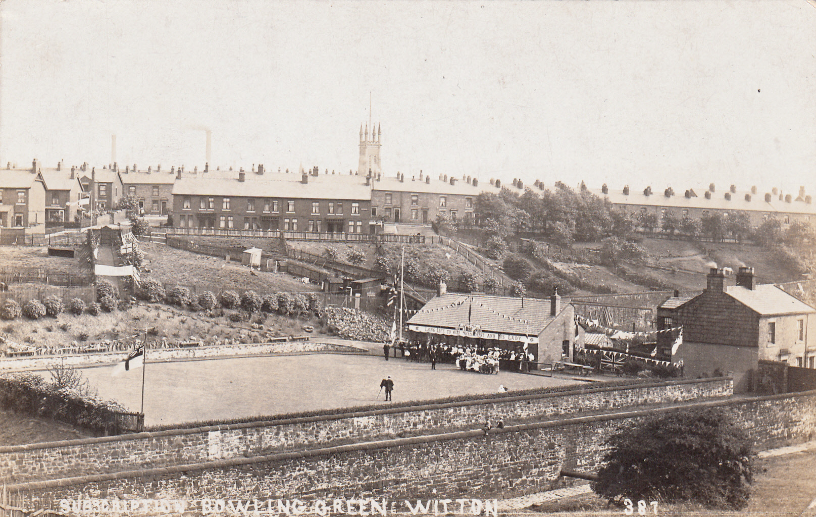
View of Witton Subscription Bowling Green situated off Pleasington Street In the early 1900’s This view taken from a field of Higher Witton Farm on the lower slopes of the River Blakewater Valley shows the river in the foreground in front of the high stone walls of Pleasington Street. It also shows that the other side of the valley has been developed by plots of land or allotments probably for the inhabitants of the many Victorian terraced houses in view and these are neatly laid out divided by bushes, hedges of fences on former fields of Redlam Farm (see map below). The long rows of Victorian terraced houses in view are alongside Redlam with Selborne Street the nearest and West View on the extreme left. In the distance can be seen the upper tower of St. Philips Church and leading down from Selborne Street can be seen an entrance path to Witton Subscription Bowling Green (this formerly ran to Redlam Farm) complete with banners and the St. Georges Flag and other flags being flown from the four corners of the bowling green.
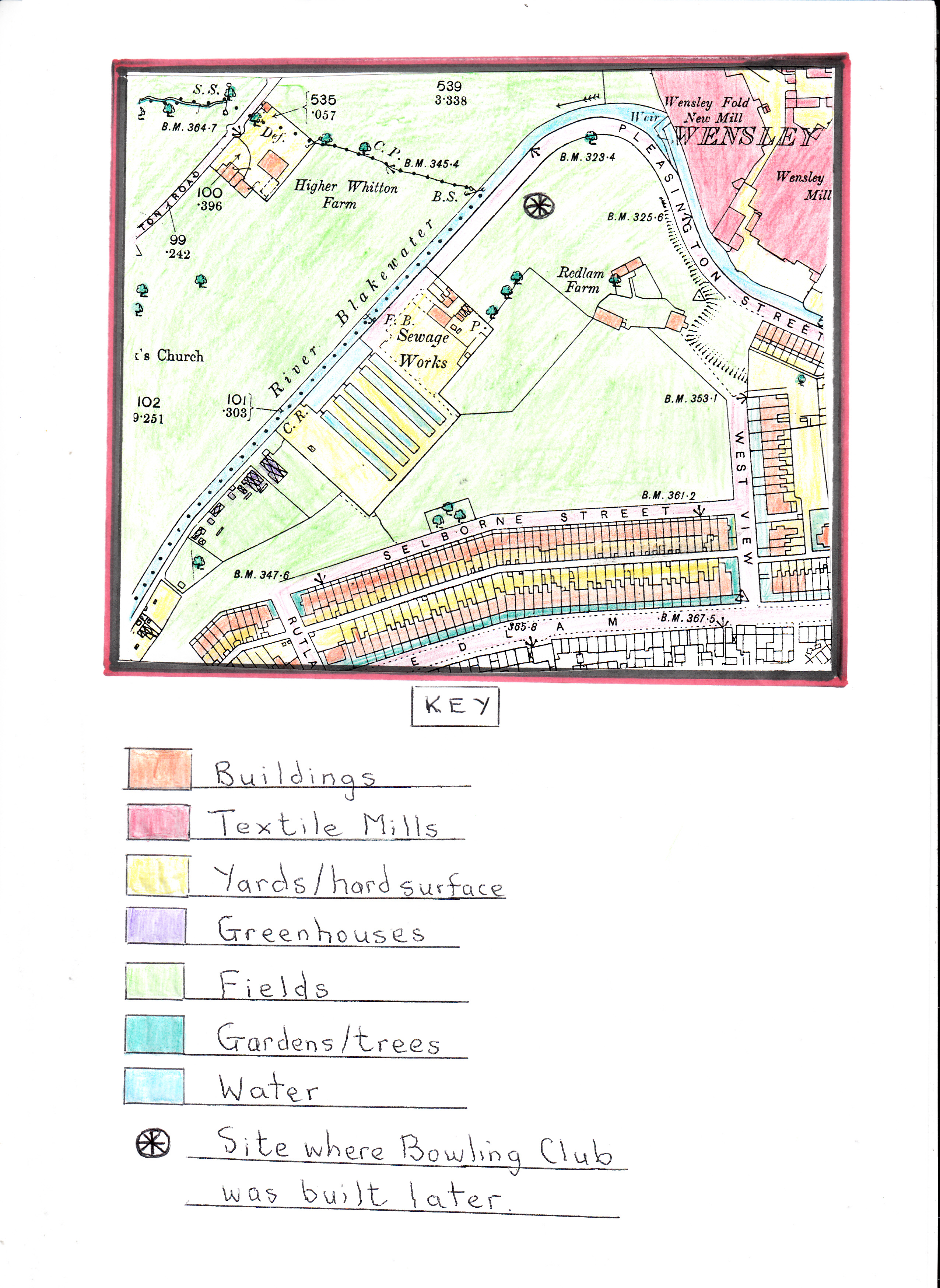
Extract from the 1894 Ordnance Survey Map of this area
Before the Witton Bowling Club was formedThe photograph shows an official photographer taking pictures of a gathering of people in front of the clubhouse from the pristine bowling green with colourful bunting completing this celebration event. This could be the official opening of the bowling green, or new club house or celebrating Presidents Day, especially as the people in view are in their “Sunday Best” clothing especially the ladies.

