The large culvert which was made under Preston New Road in 1825 when the road was made, was a favourite bathing place for the Blackburn youths. Girls also made the most of this as one old lady placed on record that when a girl, she and her playmates used to amuse themselves with scrambling up and down this “tunnel”.
There is also a report that in 1821 a lot of damage was caused by the fall of a waterspout. Vast quantities of plants and trees were washed down Snig Brook from the Revidge side.
Snig Brook was then, as it is even yet, I believe, a clear stream and got its name from the snigs or eels which were often caught in it. The brook flowed past the front of the old Snig Brook settlement and was used for every domestic purpose. These houses had gardens over the brook with a plank or stone to get over the water opposite each house. Snig Brook water has been used for brewing whiskey at least once as there is a report of an illicit still having been seized in one of the old houses opposite the brook.
In the sketch, taken from the map of 1820, we can see that there were houses on only one side of the street, the brook flowing openly on the other side. We know that some of the houses must have been built prior to 1790 because we learn from the history of St. Paul’s Church that on October 9th of that year a meeting was held at the home of Mr. John Haydock of Snig Brook regarding St. Paul’s Church.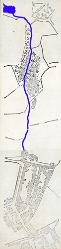
Map Showing Snig Brook
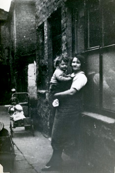
The rear of a house in Snig Brook, which was one of several sharing the yard area. Opposite to this back door
was the fronts of three cottages which could only be reached by using a passageway (ginnel) between two of the houses in Snig Brook.
Before the new road to Preston was made, Snig Brook must have been quite an important thoroughfare. Mr. Henry Sudell, when living at Woodfold Park, used to drive to town in his carriage along Billinge and Revidge, down Duke’s Brow, through Snig Brook across Blakey Moor and into Northgate. Even after Preston New Road was finished, for several years there was hardly any houses in the area. With the exception of the old house at Bank (Duke’s Brow), on the right, Bowk House and Snig Brook colony on the left, and one or two cottages at Billinge End, there was not a single dwelling on the road from Northgate until Salmesbury Hall was reached.
The Quakers of Blackburn had their meeting house in the lower part of the street Snig Brook in 1820, but as they needed larger accommodation they moved into their present premises at Paradise Lane in about 1822.
The Brook turns out of Snig Brook Street and then flows along Barley Lane, crosses Montague Street and down the lower part of Barley Lane. In this area are the names Barley Lane, Malt Street and Brewery Street which are associated with the Snig Brook Brewery.
This brewery had been built in the early 1800s and in 1820 was owned by Mr. William Clark. It was later taken over by Mr. Joseph Fairbrother, who held the office of Parish Clerk at the same time. The next owner, Mr. James Cunningham, developed the brewery and purchased a number of public houses.
From time to time there had been great contention as to who had the right to impound the overflow from Gawthorpe and the “Cans”, and when Mr. Thomas Parkinson built Peel Mill, he constructed a reservoir on the line of Snig Brook, opposite Barley Lane, which supplied that mill with water. The Peel Tannery also used the water in its business and Mr. Cunningham used the same source for his brewery.
When Mr. Cunningham impounded the water the inhabitants of Snig Brook insisted upon a tank being left for their use, and two of the residents had to collect subscriptions from those who used it, to pay for the tap etc, being kept in repair. Mr. Cunningham, who became Mayor of Blackburn in 1859, had previously built himself a large, detached house in Montague Street, which stands between Montague Street and the brewery. The house is now St. Paul’s Working Men’s Institute and Mr. Cunningham’s name is remembered by the row of houses built by the side of his home and called Cunningham Place. About 1874 he sold Snig Brook Brewery to Mr. Daniel Thwaites and also the valuable public house attachments.
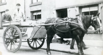
Older houses in Snig Brook. Although partially hidden behind the horse,
the ornamental stonework round the door and windows can be seen
What was the Brewery is now owned by Whalley Bros and is their motor repair works. I am told that the old brewery vats are still there and that the well-used by the brewery is still full. Some twenty years or so ago the fire brigade tried to empty it but failed. The depth is somewhere over 90 feet.
The Peel Mill and Peel Tannery were built in the area, at the lower end of Barley Lane through to Nab Lane, which had been known as Great Peel and Little Peel. The name is supposed to have come from two “peel towers” which had been in that area. If this is true then the original manor-house of the de Blackburn family may have stood here several hundred years ago, but there is no mention of such a dwelling in the earliest records. In Whitaker’s book “Whalley” he mentions that there was a moated manor-house at Little Peel, and I like to think that if that is true, perhaps the moat was filled from Snig Brook.
There certainly was a farmhouse at Great Peel before the houses and mills covered that land. At that time both Peels were surrounded by pastureland and Snig Brook, then an open stream, divided the two. At Great Peel there was a flagstone over the brook connecting Nab Lane with a cart-track extending for the length of two or three fields, then it continued as a footpath to Miles Wife’s Hey, a farmhouse near to Preston New Road. All other roads west of Snig Brook and Dukes Brow were merely footpaths.
The Ordnance Survey map of 1848 shows us that there was a Dye and Calender works at Little Peel. Later a weaving mill, called Belle Vue Mill stood at that place, in Little Peel Street and the brook flowed into their lodge. The mill was demolished at the end of the 1950s, but even up to the demolition, whenever there was a very heavy rainfall, the brook became swollen and flooded the inside of the mill. Amongst the weavers at the mill, one part of the weaving shed was always called “over t’ brook”. Referring to the part which flooded easily when there was a sudden heavy rainfall.
From Belle Vue Mill, the brook flowed underground crossing the land which became Lune Street, Mary Ellen Street and Addison Street until it joined the River Blakewater at the bottom of Addison Street, as it still does in the new culverting system.
Photograph taken in Snig Brook, showing the cottages in Winter Street,
with houses in Preston New Road on the skyline. The brook passes
under both rows of houses and follows the line of the pavement showing in this photograph
During the 1800’s the Snig Brook area was able to boast of one or two well-known people.
In 1820 James or “Jemmy” Pemberton, brother of John who worked the Pemberton Clough farm, lived in Snig Brook. He was a handloom manufacturer. He started steam looms in a little shed up a lobby near King Street bridge and afterwards built Roe Lee Mill. This mill is still there as is Pemberton Street, near the mill, which was named after him.
John Osbaldeston, the inventor, was born in Snig Brook in 1777. John was able to invent several improvements for looms, but although he had the ingenuity to plan, he lacked the practical wisdom to carry out his inventions and so remained poor. He died in the workhouse in 1862, was buried at Tockholes, and his gravestone bears the inscription: “John Osbaldeston, inventor of the weft fork”. In his later years he was acquainted with a Mr. Robert Snailham of his own home in Blakey Street. We know that he lived in an old-fashioned house, with a wide window on the ground floor. Perhaps this had formerly been the home of a handloom weaver, as there is evidence that handloom weaving was done in this area.
A lesser-known inhabitant of Snig Brook was one James Foulds. “Old Foulds” as he was known, was the senior letter carrier in Blackburn for some years. He retired on account of old age on the 31st of December 1859 and died in 1863. The notice in the local papers read: - “February 5th1863, James Foulds, of Snig Brook, for many years a letter carrier of this town.”
Perhaps one of the better known “snig Brookers” was John Smith, who became a quarry master and mason. He was elected Mayor of Blackburn from 1867 to 1869, a term of two years. He was a very colourful character and apparently involved in many schemes.
From the early sketch of 1820, showing very little housing in the area, eventually the land was built on and covered by streets and houses, including many little ginnels (a narrow passageway between two buildings) which led to houses built behind other houses. One lady has told me of the small cottage she lived in when she was first married in the early 1920s. Her home could only be reached by going up a ginnel and was one of three cottages in a shared yard area. There was also a small workshop in the same yard as well as the back entrance into about four or five houses, all sharing the same open yard area. The lady I spoke to told that there was no gas in the house (nor electricity) as they bought an oil lamp to light their homes and were quite happy there.
In the 1930s Snig Brook Street’s name was changed to Denville Street, in honour of Sir Alfred Denville, the actor.
By 1973 the old houses had all been demolished, the work being done over about twenty years, a piece at a time. The Blackburn Corporation are now in the process of building a new housing estate, called the Denville Street Redevelopment Area.
Gone are the old names of Winter Street, Blakey Street and Snig Brook, but the brook itself is still there. There has been a new culverting system laid for the water, more or less following the old stream path. For a short time, while the workmen were working on the new system, it was possible to see the old culvert of slabs of stone, forming a square with the water still running through. When the west side of Snig Brook had eventually been built on, the front of the houses had been built over the brook, but the new houses are to be built well back from the water in case it should ever wash away the foundations. But now of course, the new inhabitants of the area will never see the little brook going past their gardens as the people did 150 years ago.
Photograph A Photograph B Photograph C
Photograph A
Waterfall in Corporation Park. This is the overflow from the large lake formerly known as the “Big Can”.
Photograph B
The culvert in Winter Street at the top of Denville Street, showing the brook flowing through. This was exposed during the re-culverting for the Denville Street Redevelopment Area.
Photograph C
Peel Mill. One of the former users of the brook.
Appendix 1
Sketch of Pemberton Clough from Blackburn Weekly Standard, May 14th, 1898.
In continuing our references to the old map of Blackburn dated 1820, we give this week a sketch of the original Pemberton Clough, which is now the present Corporation Park. It continued in a line to Snig Brook and Blakey Street, at that time a very important thoroughfare. The water sprang out of the rock and formed a moderate sized mountain stream, running through a well-wooded copse or plantation. Winter Street is very distinctly seen in the map, leading into an old footpath, on a part of which St. George’s Presbyterian Church now stands. The footpath came from Shear Brow through the fields and a portion of it still remains in the form of a back passage to Strawberry Bank. The water of the stream above referred to was either carried by a culvert to the south side, or there might have been a bridge in Winter Street over the stream. The river flowed down to Little Peel, and at a point where the Blakewater passed Whalley Bank, united itself with the larger stream. We show more particularly the outlines of the property in Blakey Street, at the south end of which is seen a bowling green, which within the memory of living persons was still used for that purpose. It is now covered by old property and part of a joiner’s store yard. In place of the gardens behind Blakey Street, on the east side, what a change there is today! At the point marked “A” is the original Friends Meeting House – the one that existed before the erection of the present building in King Street, and our illustration leaves off at St. Paul’s Church.
References
“Bits of Blackburn” by J.G Shaw
“Bygone Blackburn” by G.C Miller
“Blackburn Characters of a past generation" by W.A Abram
The Blackburn Times, April 1891
The Blackburn Weekly Standard, May 1898
Acknowledgements
I would like to thank the staff of Blackburn Reference Library for their assistance; various departments of Blackburn Town Hall; Mr. A. Whalley, of Whalley Brothers Ltd and Mrs. J. Preston of Blackburn for permission to use her photographs.
Transcribed by Shazia Kasim
Published February 2026